TopoQuest Logo
Do you find TopoQuest useful?
Help keep TopoQuest running and adding new maps/features by donating!
Bitcoin:  19c7KJd3qBynnjoSw5npx9KScwjBe4ifkT
Litecoin:  LXs6TkuXGGXo1vDsWCkWVdjQX94eUKd6ui
Home View Maps Find Maps Find Places Resources & Links


Dalby Springs, Texas Topographic Map

USGS Map Title: Dalby Springs, TX
USGS Map MRC: 33094C6
DRG (GeoTIFF) Download: o33094c6.tif


Neighboring USGS Topographic Map Quads:


  Lydia, TX  
33094D7
 

  Hodgson, TX  
33094D6
 

  Malta, TX  
33094D5
 

  Coopers Chapel, TX  
33094C7
 

  Dalby Springs, TX  
33094C6
 

  Bassett, TX  
33094C5
 

  Cookville, TX  
33094B7
 

  Naples, TX  
33094B6
 

  Marietta, TX  
33094B5


Map MRC Location:

N34°
W95°
N34°
W94°
H8 H7 H6 H5 H4 H3 H2 H1
G8 G7 G6 G5 G4 G3 G2 G1
F8 F7 F6 F5 F4 F3 F2 F1
E8 E7 E6 E5 E4 E3 E2 E1
D8 D7 D6 D5 D4 D3 D2 D1
C8 C7 C6 C5 C4 C3 C2 C1
B8 B7 B6 B5 B4 B3 B2 B1
A8 A7 A6 A5 A4 A3 A2 A1
N33°
W95°
N33°
W94°

Dalby Springs, TX USGS 1:24K Topographic Map Preview:
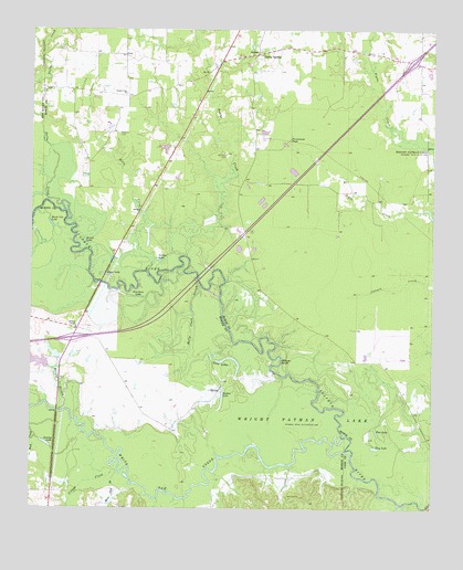
Dalby Springs, TX USGS Topographic Map
Click on map above to begin viewing in our Map Viewer.

This topographic map contains these locations and features:
Feature Name Type Latitude Longitude GNIS ID View Map
Black Cat LakeLakeN33.3244°W94.7442°1352300View Map
Boothe CreekStreamN33.3160°W94.7016°1372680View Map
Broseco Dam Number 1DamN33.2885°W94.7452°1862138View Map
Broseco RanchLocaleN33.2973°W94.7360°1352952View Map
County Line ChurchChurchN33.3585°W94.7205°1355168View Map
Dalby CreekStreamN33.3293°W94.7405°1373334View Map
Dalby SpringsPopulated PlaceN33.3690°W94.6797°1379631View Map
Dalby SpringsSpringN33.3693°W94.6805°1998623View Map
Deer Pasture DamDamN33.2885°W94.7419°1862140View Map
Deer Pasture LakeReservoirN33.2906°W94.7431°1862141View Map
Dunlap LakeLakeN33.2671°W94.7455°1356462View Map
Flag LakeLakeN33.2661°W94.6428°1357404View Map
Greenhaw LakeLakeN33.3054°W94.7161°1358397View Map
Holly CreekStreamN33.3118°W94.7135°1374110View Map
Lumpkin CemeteryCemeteryN33.3423°W94.6897°1361972View Map
Mary Lees BranchStreamN33.2579°W94.7235°1374813View Map
Molly Clark SloughGutN33.3032°W94.6999°1363043View Map
Murphy BranchStreamN33.2757°W94.7408°1375071View Map
Parker LakeLakeN33.3151°W94.7108°1364836View Map
Persimmon PondReservoirN33.3465°W94.6697°1365094View Map
Pine LakeLakeN33.2703°W94.6424°1365295View Map
Reddon LakeLakeN33.2798°W94.6902°1366271View Map
Roberts CemeteryCemeteryN33.3479°W94.7233°1366586View Map
Round LakeLakeN33.3198°W94.7333°1366930View Map
Shaw LakeLakeN33.3112°W94.7267°1368073View Map
Twin LakesLakeN33.2893°W94.6889°1370348View Map
Village CreekStreamN33.2596°W94.7224°1376596View Map
Ward CreekPopulated PlaceN33.3662°W94.6302°2034807View Map
White Oak CreekStreamN33.2640°W94.6499°1376754View Map
Willow BluffCliffN33.2887°W94.6719°1371616View Map

Note: Coordinates in the location and feature list above are referenced to NAD83 datum.


Copyright (C) 2008-2025 Ryan Niemi / Sunset Dynamics ... All Rights Reserved