TopoQuest Logo
Do you find TopoQuest useful?
Help keep TopoQuest running and adding new maps/features by donating!
Bitcoin:  19c7KJd3qBynnjoSw5npx9KScwjBe4ifkT
Litecoin:  LXs6TkuXGGXo1vDsWCkWVdjQX94eUKd6ui
Home View Maps Find Maps Find Places Resources & Links


Dunman Mountain, Texas Topographic Map

USGS Map Title: Dunman Mountain, TX
USGS Map MRC: 30098E4
DRG (GeoTIFF) Download: o30098e4.tif


Neighboring USGS Topographic Map Quads:


  Cap Mountain, TX  
30098F5
 

  Kingsland, TX  
30098F4
 

  Longhorn Cavern, TX  
30098F3
 

  Click, TX  
30098E5
 

  Dunman Mountain, TX  
30098E4
 

  Marble Falls, TX  
30098E3
 

  Blowout, TX  
30098D5
 

  Howell Mountain, TX  
30098D4
 

  Round Mountain, TX  
30098D3


Map MRC Location:

N31°
W99°
N31°
W98°
H8 H7 H6 H5 H4 H3 H2 H1
G8 G7 G6 G5 G4 G3 G2 G1
F8 F7 F6 F5 F4 F3 F2 F1
E8 E7 E6 E5 E4 E3 E2 E1
D8 D7 D6 D5 D4 D3 D2 D1
C8 C7 C6 C5 C4 C3 C2 C1
B8 B7 B6 B5 B4 B3 B2 B1
A8 A7 A6 A5 A4 A3 A2 A1
N30°
W99°
N30°
W98°

Dunman Mountain, TX USGS 1:24K Topographic Map Preview:
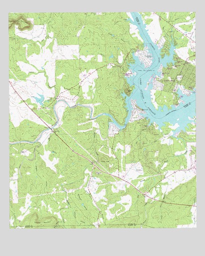
Dunman Mountain, TX USGS Topographic Map
Click on map above to begin viewing in our Map Viewer.

This topographic map contains these locations and features:
Feature Name Type Latitude Longitude GNIS ID View Map
Arant CreekStreamN30.6188°W98.4161°1351231View Map
Barry DamDamN30.5985°W98.4303°1861934View Map
Barry LakeReservoirN30.5985°W98.4303°1861935View Map
Blue Lake Subdivision Fire StationBuildingN30.5660°W98.4139°2036877View Map
Buffalo HollowValleyN30.5278°W98.4542°1353202View Map
Cedar BranchStreamN30.5266°W98.3942°1354036View Map
City of Granite ShoalsCivilN30.5895°W98.3778°2410644View Map
City of Highland HavenCivilN30.6073°W98.3950°2410761View Map
City of Horseshoe BayCivilN30.5406°W98.3786°2410794View Map
City of Sunrise Beach VillageCivilN30.5862°W98.4187°2412011View Map
Deer HollowValleyN30.5598°W98.4073°1355858View Map
Dry BranchStreamN30.5352°W98.3986°1356276View Map
Dry CreekStreamN30.6052°W98.3911°1356318View Map
Dunman MountainSummitN30.5052°W98.4836°1356465View Map
Freight Development Company LakeReservoirN30.5719°W98.4770°1861933View Map
Freight Development Company Lake DamDamN30.5719°W98.4770°1861932View Map
Granite ShoalsPopulated PlaceN30.5891°W98.3839°1388555View Map
Granite Shoals City HallBuildingN30.5909°W98.3848°2753696View Map
Granite Shoals Police DepartmentBuildingN30.5906°W98.3850°2750557View Map
Hardin HillsSummitN30.5396°W98.4364°1358769View Map
Highland HavenPopulated PlaceN30.6082°W98.3959°1777316View Map
Hoerster Lake Area Medical CenterHospitalN30.5294°W98.3978°2036880View Map
Hogpen HollowValleyN30.5411°W98.4816°1359387View Map
Horse Shoe Bay Post OfficePost OfficeN30.5319°W98.3918°2036881View Map
Horseshoe Bay Fire Department Station 2BuildingN30.5413°W98.4151°2036879View Map
Lake Lyndon B JohnsonReservoirN30.5530°W98.3910°1374767View Map
Larrimore HollowValleyN30.5136°W98.4603°1374471View Map
Lime HollowValleyN30.5757°W98.4695°1361203View Map
Little Sandy MountainSummitN30.5913°W98.4234°1361468View Map
Mesquite HillSummitN30.5319°W98.4397°1362656View Map
Our Lady of the Lake ChurchChurchN30.5938°W98.4248°1364604View Map
Pecan CemeteryCemeteryN30.5185°W98.4084°1364958View Map
Pecan CreekStreamN30.5580°W98.3853°1364961View Map
Richards BranchStreamN30.5324°W98.4503°1366421View Map
Sandy BranchStreamN30.5999°W98.4170°1376001View Map
Sandy CreekStreamN30.5744°W98.4206°1367701View Map
Sandy Harbor Subdivision Fire StationBuildingN30.5577°W98.4297°2036878View Map
Sandy MountainSummitN30.5796°W98.4209°1367726View Map
Sherwood Shores ChurchChurchN30.5863°W98.3886°1368138View Map
Ship HollowValleyN30.5584°W98.4708°1368195View Map
Spring BranchStreamN30.5949°W98.4197°1368928View Map
Station CreekStreamN30.6121°W98.3911°1376293View Map
Sunrise Beach AirportAirportN30.5988°W98.4086°1387609View Map
Sunrise Beach Baptist ChurchChurchN30.6035°W98.4159°2039566View Map
Sunrise Beach Federated ChurchChurchN30.6035°W98.4164°2039567View Map
Sunrise Beach VillagePopulated PlaceN30.5996°W98.4100°1388554View Map
Sunrise Beach Village City OfficesBuildingN30.5894°W98.4259°2753222View Map
Sunrise Beach Village HallBuildingN30.5899°W98.4228°2039565View Map
Sunrise Beach Village Police DepartmentBuildingN30.5894°W98.4259°2039564View Map
Sunrise Beach Volunteer Fire DepartmentBuildingN30.5889°W98.4250°2039562View Map
Upshaw CreekStreamN30.5735°W98.4684°1370534View Map
Walnut CreekStreamN30.5610°W98.4300°1370806View Map
West Walnut CreekStreamN30.5041°W98.4645°1371256View Map
White CreekStreamN30.5505°W98.4823°1371362View Map
Wolf Crossing CemeteryCemeteryN30.6198°W98.3941°1371845View Map

Note: Coordinates in the location and feature list above are referenced to NAD83 datum.


Copyright (C) 2008-2025 Ryan Niemi / Sunset Dynamics ... All Rights Reserved