TopoQuest Logo
Do you find TopoQuest useful?
Help keep TopoQuest running and adding new maps/features by donating!
Bitcoin:  19c7KJd3qBynnjoSw5npx9KScwjBe4ifkT
Litecoin:  LXs6TkuXGGXo1vDsWCkWVdjQX94eUKd6ui
Home View Maps Find Maps Find Places Resources & Links


East Olympia, Washington Topographic Map

USGS Map Title: East Olympia, WA
USGS Map MRC: 46122H7
DRG (GeoTIFF) Download: o46122h7.tif


Neighboring USGS Topographic Map Quads:


  Tumwater, WA  
47122A8
 

  Lacey, WA  
47122A7
 

  Nisqually, WA  
47122A6
 

  Maytown, WA  
46122H8
 

  East Olympia, WA  
46122H7
 

  Tenalquot Prairie, WA  
46122H6
 

  Violet Prairie, WA  
46122G8
 

  Bucoda, WA  
46122G7
 

  Vail, WA  
46122G6


Map MRC Location:

N47°
W123°
N47°
W122°
H8 H7 H6 H5 H4 H3 H2 H1
G8 G7 G6 G5 G4 G3 G2 G1
F8 F7 F6 F5 F4 F3 F2 F1
E8 E7 E6 E5 E4 E3 E2 E1
D8 D7 D6 D5 D4 D3 D2 D1
C8 C7 C6 C5 C4 C3 C2 C1
B8 B7 B6 B5 B4 B3 B2 B1
A8 A7 A6 A5 A4 A3 A2 A1
N46°
W123°
N46°
W122°

East Olympia, WA USGS 1:24K Topographic Map Preview:
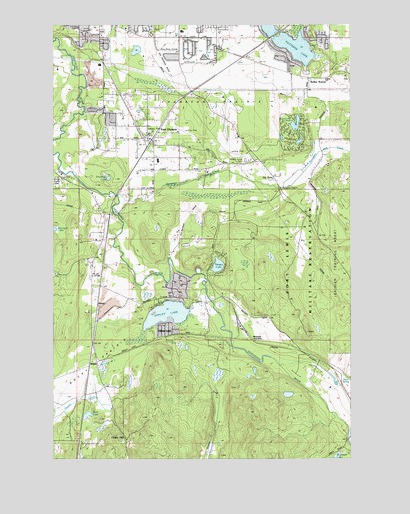
East Olympia, WA USGS Topographic Map
Click on map above to begin viewing in our Map Viewer.

This topographic map contains these locations and features:
Feature Name Type Latitude Longitude GNIS ID View Map
Capitol City Golf ClubLocaleN46.9927°W122.8153°2608400View Map
Chain HillPopulated PlaceN46.8804°W122.8457°1510870View Map
Chambers PrairieFlatN46.9801°W122.8110°1513081View Map
East OlympiaPopulated PlaceN46.9676°W122.8357°1504649View Map
East Olympia Elementary SchoolSchoolN46.9609°W122.8320°1515013View Map
East Olympia Post OfficePost OfficeN46.9667°W122.8371°2781697View Map
Fir TreePopulated PlaceN46.9562°W122.7832°1504887View Map
Flying Carpet Airport (historical)AirportN46.9651°W122.7971°1533811View Map
Hoskins FieldAirportN46.9924°W122.8270°1533866View Map
Kari FieldAirportN46.9707°W122.8221°1533864View Map
Kellys KornerPopulated PlaceN46.9848°W122.7682°1512342View Map
Mud LakeLakeN46.8874°W122.8621°1506869View Map
Offutt LakePopulated PlaceN46.9104°W122.8257°1511201View Map
Offutt LakeLakeN46.9166°W122.8285°1507147View Map
Olympia Waldorf SchoolSchoolN46.9685°W122.8362°1515017View Map
Pattison LakeLakeN46.9953°W122.7775°1510726View Map
PlumbPopulated PlaceN46.9282°W122.8562°1509684View Map
Puget Sound High SchoolSchoolN46.9990°W122.7993°1514991View Map
Rocky PrairieFlatN46.8970°W122.8640°1507891View Map
SegaleLocaleN46.9034°W122.8515°1512845View Map
Sheehan LakeLakeN46.9557°W122.8529°1508264View Map
Silver SpringLakeN46.8978°W122.7584°1508351View Map
SkookumchuckPopulated PlaceN46.9054°W122.7710°1511320View Map
Spurgeon CreekStreamN46.9512°W122.8487°1508650View Map
Sunwood LakeLakeN46.9700°W122.7738°1512846View Map
Tempo LakeReservoirN46.9304°W122.8070°1513485View Map
Tempo Lake DamDamN46.9298°W122.8096°1532053View Map
Thurston CountyCivilN46.9296°W122.8323°1529226View Map
Thurston County Fire District 6 East Olympia Fire District Station 61 HeadquartersBuildingN46.9693°W122.8369°2643319View Map
Thurston County Fire District 6 East Olympia Fire District Station 62BuildingN46.9173°W122.8116°2643287View Map
Thurston County Fire District 6 East Olympia Fire District Station 64BuildingN46.9495°W122.8577°2619474View Map
Thurston County Fire District 6 East Olympia Fire District Station 65BuildingN46.9718°W122.7675°2643320View Map
Western JunctionPopulated PlaceN46.9090°W122.7924°1511420View Map

Note: Coordinates in the location and feature list above are referenced to NAD83 datum.


Copyright (C) 2008-2025 Ryan Niemi / Sunset Dynamics ... All Rights Reserved