TopoQuest Logo
Do you find TopoQuest useful?
Help keep TopoQuest running and adding new maps/features by donating!
Bitcoin:  19c7KJd3qBynnjoSw5npx9KScwjBe4ifkT
Litecoin:  LXs6TkuXGGXo1vDsWCkWVdjQX94eUKd6ui
Home View Maps Find Maps Find Places Resources & Links


Violet Prairie, Washington Topographic Map

USGS Map Title: Violet Prairie, WA
USGS Map MRC: 46122G8
DRG (GeoTIFF) Download: o46122g8.tif


Neighboring USGS Topographic Map Quads:


  Littlerock, WA  
46123H1
 

  Maytown, WA  
46122H8
 

  East Olympia, WA  
46122H7
 

  Rochester, WA  
46123G1
 

  Violet Prairie, WA  
46122G8
 

  Bucoda, WA  
46122G7
 

  Adna, WA  
46123F1
 

  Centralia, WA  
46122F8
 

  Logan Hill, WA  
46122F7


Map MRC Location:

N47°
W123°
N47°
W122°
H8 H7 H6 H5 H4 H3 H2 H1
G8 G7 G6 G5 G4 G3 G2 G1
F8 F7 F6 F5 F4 F3 F2 F1
E8 E7 E6 E5 E4 E3 E2 E1
D8 D7 D6 D5 D4 D3 D2 D1
C8 C7 C6 C5 C4 C3 C2 C1
B8 B7 B6 B5 B4 B3 B2 B1
A8 A7 A6 A5 A4 A3 A2 A1
N46°
W123°
N46°
W122°

Violet Prairie, WA USGS 1:24K Topographic Map Preview:
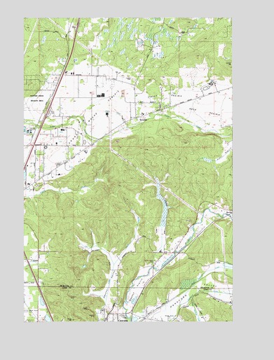
Violet Prairie, WA USGS Topographic Map
Click on map above to begin viewing in our Map Viewer.

This topographic map contains these locations and features:
Feature Name Type Latitude Longitude GNIS ID View Map
Cupacoffee CreekStreamN46.7605°W122.9516°2573473View Map
Davis HillSummitN46.7509°W122.9721°1512937View Map
Dunlap PondReservoirN46.7997°W122.9694°1532861View Map
Dunlap Pond DamDamN46.7998°W122.9696°1532860View Map
ForanLocaleN46.7590°W122.9893°1512960View Map
Grand Mound PrairieFlatN46.8220°W122.9840°1506816View Map
Hanaford ValleyValleyN46.7507°W122.9282°1505364View Map
Kiwanis Vocational SchoolSchoolN46.7526°W122.9529°1515086View Map
Kyte DamDamN46.7748°W122.9629°1532574View Map
Lemon HillSummitN46.8559°W122.8768°1512386View Map
Lewis County Fire District 12 Riverside Fire Authority Station 3BuildingN46.7523°W122.9314°2643831View Map
Majestic MineMineN46.7526°W122.9585°1506436View Map
Monarch MineMineN46.7607°W122.9732°1506755View Map
Monte Vista Poultry Detention PondReservoirN46.8574°W122.9703°1533003View Map
Monte Vista Poultry Detention Pond DamDamN46.8582°W122.9712°1533002View Map
North Hanaford CreekStreamN46.7562°W122.9076°1507075View Map
Rock PrairieFlatN46.8376°W122.8876°1507862View Map
Sorrell AirportAirportN46.8497°W122.9347°1533996View Map
South Hanaford CreekStreamN46.7587°W122.9024°1508549View Map
Stoker MineMineN46.7554°W122.9629°1508754View Map
SunnydalePopulated PlaceN46.8337°W122.9329°1508824View Map
Thurston County Fire District 12 Tenino Fire Department Station 12 - 2BuildingN46.8375°W122.9181°2643288View Map
Thurston County Fire District 16 Gibson Valley Fire DepartmentBuildingN46.7787°W122.9166°2619547View Map
Violet PrairieFlatN46.8418°W122.9160°1509233View Map
Wissler's AirportAirportN46.8404°W122.9162°1533997View Map
Zenkner ValleyValleyN46.7557°W122.9529°1509675View Map

Note: Coordinates in the location and feature list above are referenced to NAD83 datum.


Copyright (C) 2008-2025 Ryan Niemi / Sunset Dynamics ... All Rights Reserved