TopoQuest Logo
Do you find TopoQuest useful?
Help keep TopoQuest running and adding new maps/features by donating!
Bitcoin:  19c7KJd3qBynnjoSw5npx9KScwjBe4ifkT
Litecoin:  LXs6TkuXGGXo1vDsWCkWVdjQX94eUKd6ui
Home View Maps Find Maps Find Places Resources & Links


English Lake, Indiana Topographic Map

USGS Map Title: English Lake, IN
USGS Map MRC: 41086C7
DRG (GeoTIFF) Download: o41086c7.tif


Neighboring USGS Topographic Map Quads:


  Wanatah, IN  
41086D8
 

  Hanna, IN  
41086D7
 

  Kingsford Heights, IN  
41086D6
 

  La Crosse, IN  
41086C8
 

  English Lake, IN  
41086C7
 

  Knox West, IN  
41086C6
 

  San Pierre, IN  
41086B8
 

  North Judson, IN  
41086B7
 

  Denham, IN  
41086B6


Map MRC Location:

N42°
W87°
N42°
W86°
H8 H7 H6 H5 H4 H3 H2 H1
G8 G7 G6 G5 G4 G3 G2 G1
F8 F7 F6 F5 F4 F3 F2 F1
E8 E7 E6 E5 E4 E3 E2 E1
D8 D7 D6 D5 D4 D3 D2 D1
C8 C7 C6 C5 C4 C3 C2 C1
B8 B7 B6 B5 B4 B3 B2 B1
A8 A7 A6 A5 A4 A3 A2 A1
N41°
W87°
N41°
W86°

English Lake, IN USGS 1:24K Topographic Map Preview:
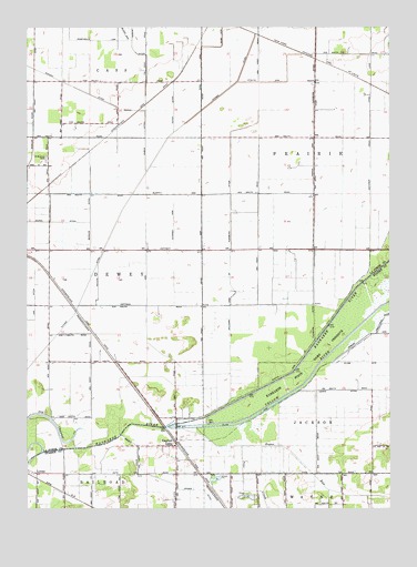
English Lake, IN USGS Topographic Map
Click on map above to begin viewing in our Map Viewer.

This topographic map contains these locations and features:
Feature Name Type Latitude Longitude GNIS ID View Map
Archangels LandingAirportN41.2599°W86.8728°2677092View Map
Bessler DitchCanalN41.3278°W86.8531°430855View Map
Bogus RunStreamN41.2706°W86.8167°431299View Map
Davidson DrainCanalN41.3428°W86.7567°433337View Map
English LakePopulated PlaceN41.2659°W86.8236°434205View Map
Gloor ArmCanalN41.3728°W86.8411°435131View Map
Hoffman ArmCanalN41.3128°W86.8339°436273View Map
Hundt DitchCanalN41.3592°W86.8245°436608View Map
Kaukakee State Fish and Wildlife AreaParkN41.2875°W86.7792°437162View Map
Kline ArmCanalN41.2875°W86.7542°446763View Map
Kuehn DitchCanalN41.3689°W86.8384°437468View Map
Lemke DitchCanalN41.2803°W86.7550°437769View Map
LomaxPopulated PlaceN41.2589°W86.8717°438234View Map
Luedtke Dairy FarmLocaleN41.2522°W86.8286°2634528View Map
Murphy ArmCanalN41.3312°W86.8197°439890View Map
Pine CreekStreamN41.2659°W86.8011°441152View Map
Pitner DitchCanalN41.3395°W86.8314°441206View Map
RunnymedePopulated PlaceN41.3023°W86.8584°446713View Map
Saint Martins CemeteryCemeteryN41.3406°W86.8683°442683View Map
Stassen ArmCanalN41.3231°W86.8242°444084View Map
Stoltz ArmCanalN41.3606°W86.7906°444194View Map
Township of PrairieCivilN41.3359°W86.7765°453770View Map
William Arm of Tuesburg DitchCanalN41.3145°W86.8050°446058View Map
Yellow RiverStreamN41.2712°W86.8264°452845View Map

Note: Coordinates in the location and feature list above are referenced to NAD83 datum.


Copyright (C) 2008-2024 Ryan Niemi / Sunset Dynamics ... All Rights Reserved