TopoQuest Logo
Do you find TopoQuest useful?
Help keep TopoQuest running and adding new maps/features by donating!
Bitcoin:  19c7KJd3qBynnjoSw5npx9KScwjBe4ifkT
Litecoin:  LXs6TkuXGGXo1vDsWCkWVdjQX94eUKd6ui
Home View Maps Find Maps Find Places Resources & Links


Canastota, New York Topographic Map

USGS Map Title: Canastota, NY
USGS Map MRC: 43075A7
DRG (GeoTIFF) Download: o43075a7.tif


Neighboring USGS Topographic Map Quads:


  Cleveland, NY  
43075B8
 

  Jewell, NY  
43075B7
 

  Sylvan Beach, NY  
43075B6
 

  Manlius, NY  
43075A8
 

  Canastota, NY  
43075A7
 

  Oneida, NY  
43075A6
 

  Oran, NY  
42075H8
 

  Cazenovia, NY  
42075H7
 

  Morrisville, NY  
42075H6


Map MRC Location:

N44°
W76°
N44°
W75°
H8 H7 H6 H5 H4 H3 H2 H1
G8 G7 G6 G5 G4 G3 G2 G1
F8 F7 F6 F5 F4 F3 F2 F1
E8 E7 E6 E5 E4 E3 E2 E1
D8 D7 D6 D5 D4 D3 D2 D1
C8 C7 C6 C5 C4 C3 C2 C1
B8 B7 B6 B5 B4 B3 B2 B1
A8 A7 A6 A5 A4 A3 A2 A1
N43°
W76°
N43°
W75°

Canastota, NY USGS 1:24K Topographic Map Preview:
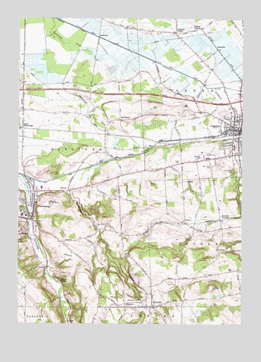
Canastota, NY USGS Topographic Map
Click on map above to begin viewing in our Map Viewer.

This topographic map contains these locations and features:
Feature Name Type Latitude Longitude GNIS ID View Map
Allis CemeteryCemeteryN43.0857°W75.7990°2542848View Map
Allis HillSummitN43.0878°W75.7999°942383View Map
Avon TheatreBuildingN43.0789°W75.7519°2416821View Map
Believers ChapelChurchN43.0632°W75.7997°2597840View Map
BlakesleePopulated PlaceN43.0070°W75.8146°944218View Map
Brick FarmLocaleN43.0008°W75.8542°2547244View Map
Brinkerhoff HillSummitN43.0356°W75.8744°944760View Map
Campbells CornersLocaleN43.1192°W75.7871°945709View Map
CanastotaPopulated PlaceN43.0795°W75.7507°945755View Map
Canastota Airport (historical)AirportN43.0703°W75.7697°2400209View Map
Canastota CreekStreamN43.0967°W75.7671°945756View Map
Canastota High School (historical)SchoolN43.0817°W75.7503°2416817View Map
Canastota Post OfficePost OfficeN43.0787°W75.7510°2598886View Map
Canastota Public LibraryBuildingN43.0783°W75.7558°2416818View Map
Canastota ReservoirReservoirN43.0434°W75.7566°945757View Map
Canastota Village Water Pollution Control PlantLocaleN43.0955°W75.7605°2597237View Map
Canastota Volunteer Fire DepartmentBuildingN43.0779°W75.7503°2416822View Map
Casolwood Golf CourseLocaleN43.0887°W75.7811°2598906View Map
ChittenangoPopulated PlaceN43.0451°W75.8666°969996View Map
Chittenango Fire DepartmentBuildingN43.0503°W75.8664°2718541View Map
Chittenango High SchoolSchoolN43.0445°W75.8729°2597837View Map
Chittenango Police DepartmentBuildingN43.0450°W75.8657°2780662View Map
Chittenango Post OfficePost OfficeN43.0545°W75.8604°2598888View Map
Chittenango Rest AreaLocaleN43.0961°W75.8416°2598903View Map
Chittenango Station Free Methodist ChurchChurchN43.0878°W75.8731°2597845View Map
Chittenango United Methodist ChurchChurchN43.0416°W75.8661°2597846View Map
Chittenango Village HallBuildingN43.0450°W75.8657°2598923View Map
CottonsPopulated PlaceN43.0417°W75.7819°947533View Map
Cranson CemeteryCemeteryN43.0207°W75.7690°2542851View Map
Cranson HillSummitN43.0140°W75.7671°947710View Map
Crossroads Community ChurchChurchN43.0878°W75.8736°2597849View Map
Douglas DitchCanalN43.1206°W75.8407°948602View Map
East BostonPopulated PlaceN43.0834°W75.8174°948986View Map
Evangelical Assembly of GodChurchN43.0527°W75.8642°2597852View Map
First Baptist ChurchChurchN43.0747°W75.7519°2416823View Map
First Presbyterian ChurchChurchN43.0783°W75.7542°2416820View Map
First Presbyterian ChurchChurchN43.0493°W75.8673°2597858View Map
Harrington CemeteryCemeteryN43.0444°W75.8692°2542827View Map
Kingdom Hall of Jehovahs WitnessesChurchN43.0917°W75.8720°2597860View Map
Lake Street Elementary SchoolSchoolN43.0441°W75.8706°2597830View Map
Lakeview AirportAirportN43.0093°W75.8275°977959View Map
Lenox Memorial HospitalHospitalN43.0783°W75.7550°2416819View Map
Lenox Rural CemeteryCemeteryN43.0642°W75.7666°955203View Map
Lillies PinnacleSummitN43.0495°W75.8566°955304View Map
Luther AirportAirportN43.0285°W75.8450°977958View Map
Mount Pleasant CemeteryCemeteryN43.0632°W75.7546°957887View Map
North ChittenangoPopulated PlaceN43.0812°W75.8727°958745View Map
Oakwood CemeteryCemeteryN43.0473°W75.8727°959195View Map
OniontownPopulated PlaceN43.1173°W75.8299°959386View Map
Owlville CreekStreamN43.0967°W75.7702°959700View Map
PerryvillePopulated PlaceN43.0070°W75.7994°960216View Map
Perryville CemeteryCemeteryN43.0045°W75.8002°2542847View Map
Perryville FallsFallsN43.0098°W75.8060°960217View Map
Perryville QuarryMineN43.0181°W75.8061°2712450View Map
Perryville United Methodist ChurchChurchN43.0072°W75.8055°2597871View Map
Peterboro Street Elementary SchoolSchoolN43.0818°W75.7500°2597832View Map
Quality HillPopulated PlaceN43.0670°W75.7749°962064View Map
Saint Agatha's Roman Catholic ChurchChurchN43.0853°W75.7508°2416814View Map
Saint Paul's Episcopal ChurchChurchN43.0445°W75.8663°2597877View Map
Smithland FarmsLocaleN43.0411°W75.8006°2547250View Map
Stonehedge Health and Rehabilitation Center ChittenangoBuildingN43.0484°W75.8690°2598902View Map
SullivanPopulated PlaceN43.0545°W75.8469°966742View Map
Sullivan CemeteryCemeteryN43.0825°W75.8231°2542828View Map
Sullivan Free Library Chittenango BranchBuildingN43.0441°W75.8663°2598918View Map
Sulphur SpringsPopulated PlaceN43.0176°W75.8510°972320View Map
Town of LenoxCivilN43.1113°W75.7582°979139View Map
Trinity Episcopal ChurchChurchN43.0725°W75.7519°2416825View Map
Valley Mobile Home ParkPopulated PlaceN43.0009°W75.8457°2598897View Map
Village of CanastotaCivilN43.0836°W75.7559°2391577View Map
Village of ChittenangoCivilN43.0461°W75.8748°2391607View Map
Walkers CornersPopulated PlaceN43.1212°W75.7732°973200View Map

Note: Coordinates in the location and feature list above are referenced to NAD83 datum.


Copyright (C) 2008-2025 Ryan Niemi / Sunset Dynamics ... All Rights Reserved