TopoQuest Logo
Do you find TopoQuest useful?
Help keep TopoQuest running and adding new maps/features by donating!
Bitcoin:  19c7KJd3qBynnjoSw5npx9KScwjBe4ifkT
Litecoin:  LXs6TkuXGGXo1vDsWCkWVdjQX94eUKd6ui
Home View Maps Find Maps Find Places Resources & Links


Cleveland, New York Topographic Map

USGS Map Title: Cleveland, NY
USGS Map MRC: 43075B8
DRG (GeoTIFF) Download: o43075b8.tif


Neighboring USGS Topographic Map Quads:


  Mallory, NY  
43076C1
 

  Panther Lake, NY  
43075C8
 

  Camden West, NY  
43075C7
 

  Cicero, NY  
43076B1
 

  Cleveland, NY  
43075B8
 

  Jewell, NY  
43075B7
 

  Syracuse East, NY  
43076A1
 

  Manlius, NY  
43075A8
 

  Canastota, NY  
43075A7


Map MRC Location:

N44°
W76°
N44°
W75°
H8 H7 H6 H5 H4 H3 H2 H1
G8 G7 G6 G5 G4 G3 G2 G1
F8 F7 F6 F5 F4 F3 F2 F1
E8 E7 E6 E5 E4 E3 E2 E1
D8 D7 D6 D5 D4 D3 D2 D1
C8 C7 C6 C5 C4 C3 C2 C1
B8 B7 B6 B5 B4 B3 B2 B1
A8 A7 A6 A5 A4 A3 A2 A1
N43°
W76°
N43°
W75°

Cleveland, NY USGS 1:24K Topographic Map Preview:
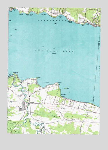
Cleveland, NY USGS Topographic Map
Click on map above to begin viewing in our Map Viewer.

This topographic map contains these locations and features:
Feature Name Type Latitude Longitude GNIS ID View Map
Amazing Grace Christian FellowshipChurchN43.2473°W75.8803°2714706View Map
Anchorage MarinaLocaleN43.1812°W75.9905°973569View Map
App's Landing MarinaHarborN43.2320°W75.8814°2715225View Map
Barry's Mobile Home ParkPopulated PlaceN43.2480°W75.9507°2715148View Map
Bernhard BayBayN43.2409°W75.9282°943741View Map
Bernhard PointCapeN43.2345°W75.8991°973370View Map
Bernhards BayPopulated PlaceN43.2445°W75.9335°943742View Map
Bernhards Bay Methodist ChurchChurchN43.2439°W75.9297°2542525View Map
Billington BayBayN43.1773°W75.9505°943978View Map
Black CreekStreamN43.1317°W75.9505°944114View Map
Black CreekStreamN43.2320°W75.8816°944116View Map
Black Creek School (historical)SchoolN43.1380°W75.9543°2463876View Map
Boathouse MarinaHarborN43.2462°W75.9982°2715226View Map
BridgeportPopulated PlaceN43.1553°W75.9694°944727View Map
Bridgeport CemeteryCemeteryN43.1478°W75.9739°2542161View Map
Bridgeport Census Designated PlaceCensusN43.1561°W75.9654°2389241View Map
Bridgeport Elementary SchoolSchoolN43.1623°W75.9701°2463879View Map
Bridgeport Fire CompanyBuildingN43.1559°W75.9668°2701112View Map
Bridgeport Post OfficePost OfficeN43.1534°W75.9741°2598885View Map
Briggs BayBayN43.1640°W75.9246°944736View Map
Bushnell School (historical)SchoolN43.1497°W75.8965°2463878View Map
Chapman ParkParkN43.1528°W75.8944°969988View Map
Chittenango CreekStreamN43.1837°W75.9933°946596View Map
ClevelandPopulated PlaceN43.2403°W75.8838°946846View Map
Cleveland Bible ChapelChurchN43.2473°W75.8803°2714718View Map
Cleveland Elementary SchoolSchoolN43.2368°W75.8925°2713734View Map
Cleveland Post OfficePost OfficeN43.2326°W75.8836°2713520View Map
Cleveland Village CemeteryCemeteryN43.2369°W75.8794°2542526View Map
Cleveland Village Wastewater Treatment PlantLocaleN43.2381°W75.8822°2714932View Map
Cleveland Volunteer Fire DepartmentBuildingN43.2365°W75.8888°2701124View Map
Clough PointCapeN43.2448°W75.9844°946916View Map
Cold Spring BrookStreamN43.2326°W75.8802°947064View Map
Crandell CreekStreamN43.2434°W75.9277°947689View Map
Dakin BayBayN43.2442°W75.9683°947994View Map
Dakin Bay School (historical)SchoolN43.2462°W75.9686°2463875View Map
Dakin CreekStreamN43.2459°W75.9705°947995View Map
Dakin ShoalBarN43.2242°W75.9716°947996View Map
Damon PointCapeN43.1801°W75.9608°948007View Map
Deyo CemeteryCemeteryN43.1578°W75.9706°2542727View Map
Dickinson IslandIslandN43.2359°W75.9185°948444View Map
Dickinson PointCapeN43.2376°W75.9163°948445View Map
Dutchman IslandIslandN43.1703°W75.9219°948873View Map
Eaton CornersPopulated PlaceN43.1376°W75.8974°949318View Map
Fisher BayBayN43.1803°W75.9813°950155View Map
Grass IslandIslandN43.2281°W75.9921°951538View Map
GrassyshoalBarN43.2281°W75.9913°973568View Map
Hitchcock PointCapeN43.1837°W75.9905°952900View Map
Lakeside Rural CemeteryCemeteryN43.2448°W75.9292°2542524View Map
Lakewood School (historical)SchoolN43.1549°W75.9317°2463877View Map
Little IslandIslandN43.2370°W75.9991°955566View Map
Lydiatt CreekStreamN43.2431°W75.9316°956165View Map
Matthews PointCapeN43.2440°W75.9730°956674View Map
Methodist Church of ClevelandChurchN43.2341°W75.8861°2714749View Map
Negro BrookStreamN43.1298°W75.9499°958333View Map
North Shore Volunteer Emergency SquadBuildingN43.2363°W75.8914°2719259View Map
Oneida LakeLakeN43.2032°W75.9098°959369View Map
Oneida Lake Fish Cultural StationLocaleN43.2494°W75.9983°2543410View Map
Pancake ShoalBarN43.2223°W75.9960°959810View Map
Plymouth IslandIslandN43.2428°W75.9710°960786View Map
Potter BayBayN43.2345°W75.8932°961031View Map
Rogues' Roost Golf and Country ClubLocaleN43.1487°W75.9236°2598909View Map
Saint Mary's ChurchChurchN43.2322°W75.8850°2714776View Map
Scriba CreekStreamN43.2456°W75.9946°970590View Map
Shackelton PointCapeN43.1751°W75.9338°964900View Map
Shackelton ShoalsBarN43.1981°W75.9219°973566View Map
Smith RidgeRidgeN43.1384°W75.9044°965511View Map
Smith's Ridge CemeteryCemeteryN43.1383°W75.9164°2542787View Map
Spruce Grove MarinaHarborN43.2442°W75.9809°973567View Map
Sulphur Spring BrookStreamN43.2348°W75.8957°966753View Map
Sunset BayBayN43.2462°W75.9905°966829View Map
Taft BayBayN43.2440°W75.9527°966989View Map
Village of ClevelandCivilN43.2398°W75.8847°2391612View Map
Willard IslandIslandN43.2351°W75.9382°971282View Map
Willard PointCapeN43.2409°W75.9382°971285View Map

Note: Coordinates in the location and feature list above are referenced to NAD83 datum.


Copyright (C) 2008-2024 Ryan Niemi / Sunset Dynamics ... All Rights Reserved