TopoQuest Logo
Do you find TopoQuest useful?
Help keep TopoQuest running and adding new maps/features by donating!
Bitcoin:  19c7KJd3qBynnjoSw5npx9KScwjBe4ifkT
Litecoin:  LXs6TkuXGGXo1vDsWCkWVdjQX94eUKd6ui
Home View Maps Find Maps Find Places Resources & Links


Hog Island, Virginia Topographic Map

USGS Map Title: Hog Island, VA
USGS Map MRC: 37076B6
DRG (GeoTIFF) Download: o37076b6.tif


Neighboring USGS Topographic Map Quads:


  Norge, VA  
37076C7
 

  Williamsburg, VA  
37076C6
 

  Clay Bank, VA  
37076C5
 

  Surry, VA  
37076B7
 

  Hog Island, VA  
37076B6
 

  Yorktown, VA  
37076B5
 

  Runnymede, VA  
37076A7
 

  Bacons Castle, VA  
37076A6
 

  Mulberry Island, VA  
37076A5


Map MRC Location:

N38°
W77°
N38°
W76°
H8 H7 H6 H5 H4 H3 H2 H1
G8 G7 G6 G5 G4 G3 G2 G1
F8 F7 F6 F5 F4 F3 F2 F1
E8 E7 E6 E5 E4 E3 E2 E1
D8 D7 D6 D5 D4 D3 D2 D1
C8 C7 C6 C5 C4 C3 C2 C1
B8 B7 B6 B5 B4 B3 B2 B1
A8 A7 A6 A5 A4 A3 A2 A1
N37°
W77°
N37°
W76°

Hog Island, VA USGS 1:24K Topographic Map Preview:
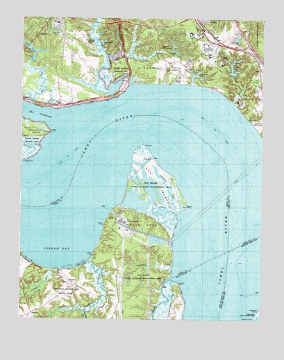
Hog Island, VA USGS Topographic Map
Click on map above to begin viewing in our Map Viewer.

This topographic map contains these locations and features:
Feature Name Type Latitude Longitude GNIS ID View Map
Bayse PointCapeN37.1518°W76.7125°1462845View Map
Birchwood ParkPopulated PlaceN37.2465°W76.7305°1495272View Map
Black PointCapeN37.2029°W76.7344°1478223View Map
Blizzards CreekStreamN37.1540°W76.7497°1463572View Map
Brewery Road DamDamN37.2285°W76.6413°1490150View Map
Brewery Road LakeReservoirN37.2274°W76.6398°1490151View Map
Brown HouseBuildingN37.1354°W76.7308°1955697View Map
Busch Corporate CenterLocaleN37.2464°W76.6622°2092548View Map
Busch GardensParkN37.2335°W76.6458°1779397View Map
Camp James RiverLocaleN37.2132°W76.6366°1478312View Map
Camp LightfootLocaleN37.2143°W76.7333°1779400View Map
Castle Mill RunStreamN37.1279°W76.7166°1464523View Map
Chestnut BluffsCliffN37.1479°W76.7438°1464803View Map
ChippokesPopulated PlaceN37.1413°W76.7252°1495388View Map
Chippokes Farm and Forestry MuseumBuildingN37.1413°W76.7280°1955692View Map
Chippokes MansionBuildingN37.1385°W76.7205°1955700View Map
Chippokes PlantationLocaleN37.1376°W76.7205°1740129View Map
Chippokes Plantation State ParkParkN37.1363°W76.7252°1740130View Map
Cobham BayBayN37.1560°W76.7305°1465033View Map
College CreekStreamN37.2229°W76.6936°1478405View Map
College RunStreamN37.1454°W76.7319°1465110View Map
College Run TrailTrailN37.1413°W76.7252°1955694View Map
Conference Center DamDamN37.2268°W76.6613°1490149View Map
Country Club AcresPopulated PlaceN37.2469°W76.6475°2091371View Map
Drewry PointCapeN37.1646°W76.7069°1465952View Map
Forestry TrailTrailN37.1401°W76.7269°1955695View Map
Goose Hill ChannelChannelN37.1879°W76.7316°1478669View Map
Gravel NeckCapeN37.1604°W76.6894°1467389View Map
GrovePopulated PlaceN37.2299°W76.6269°1495629View Map
Grove CreekStreamN37.2160°W76.6411°1478704View Map
Halfway CreekStreamN37.2346°W76.7058°1478715View Map
Hampton Roads Sanitation District Williamsburg Sewage Treatment PlantLocaleN37.2150°W76.6358°2520565View Map
HighgatePopulated PlaceN37.1274°W76.7433°1495689View Map
Hog IslandIslandN37.1813°W76.6780°1468100View Map
Hog Island CreekGutN37.1704°W76.6741°1468106View Map
Hog Island State Waterfowl RefugeParkN37.1788°W76.6819°1468107View Map
Hog PointCapeN37.1982°W76.6863°1468112View Map
Holloman Child Development and Education CenterSchoolN37.2453°W76.6528°2464992View Map
HollybrookPopulated PlaceN37.2440°W76.7452°1495706View Map
HomewoodPopulated PlaceN37.1918°W76.6819°1477422View Map
Homewood CreekStreamN37.1693°W76.6691°1468201View Map
Hunnicut CreekStreamN37.1451°W76.6713°1468385View Map
Interchange 243CrossingN37.2390°W76.6322°1779452View Map
James City County Fire Department / Ambulance Station 2BuildingN37.2336°W76.6295°2331719View Map
James City County Fire Department AdministrationBuildingN37.2442°W76.6624°2331802View Map
James City County Government CenterLocaleN37.2447°W76.6833°2092549View Map
James River TrailTrailN37.1429°W76.7186°1955693View Map
Kingsmill DamDamN37.2368°W76.6719°1490148View Map
Kingsmill NeckCapeN37.2293°W76.6763°1478898View Map
Kingsmill on the JamesPopulated PlaceN37.2407°W76.6755°1779413View Map
Kingsmill Plantation SiteLocaleN37.2288°W76.6761°1779414View Map
Kingsmill Police DepartmentBuildingN37.2442°W76.6623°2767108View Map
Kingsmill PondReservoirN37.2360°W76.6698°1502051View Map
Kingsmill River Golf CourseLocaleN37.2297°W76.6697°2092550View Map
KingspointPopulated PlaceN37.2415°W76.7036°1779415View Map
KingswoodPopulated PlaceN37.2485°W76.7402°1495795View Map
Lake PowellReservoirN37.2316°W76.7456°1502100View Map
Lake Powell DamDamN37.2321°W76.7447°1490144View Map
Lawnes CreekStreamN37.1421°W76.6716°1469200View Map
Lawnes PointCapeN37.1399°W76.6672°1469202View Map
Little Zion ChurchChurchN37.2246°W76.6275°1779417View Map
Lower Chippokes CreekStreamN37.1490°W76.7141°1477919View Map
Lower Chippokes Creek TrailTrailN37.1401°W76.7152°1955696View Map
Lower PointCapeN37.1901°W76.7488°1478998View Map
Mill CreekStreamN37.2140°W76.7441°1479092View Map
Moody PondReservoirN37.2246°W76.6709°1779419View Map
Morningside of Williamsburg Assisted Living FacilityBuildingN37.2492°W76.6653°2520015View Map
Mount Gilead Christian AcademySchoolN37.2224°W76.6252°2519569View Map
Mount Gilead ChurchChurchN37.2226°W76.6252°1779420View Map
Mulberry PointCapeN37.1251°W76.6277°1479174View Map
Osbourne HouseBuildingN37.1310°W76.7388°1955698View Map
Rawls Byrd Elementary SchoolSchoolN37.2480°W76.7318°1779428View Map
Rhine RiverReservoirN37.2274°W76.6398°1779429View Map
Roberts DistrictCivilN37.2148°W76.6602°1927468View Map
Spratley HouseBuildingN37.1363°W76.7302°1955699View Map
Surry Nuclear Power Station Fire ServiceBuildingN37.1646°W76.6995°2660558View Map
Surry Nuclear PowerplantLocaleN37.1658°W76.6981°1740159View Map
The ColonyPopulated PlaceN37.2353°W76.7472°2092552View Map
The Market Place Shops Shopping CenterLocaleN37.2438°W76.6588°1779431View Map
The ThorofareChannelN37.2107°W76.7488°1479722View Map
Travis CemeteryCemeteryN37.2040°W76.7491°1479756View Map
Tribell Shoal ChannelChannelN37.1968°W76.6413°1479760View Map
Village Shops At Kingsmill Shopping CenterLocaleN37.2458°W76.6561°2091372View Map
Walnut PointCapeN37.1721°W76.6638°1476287View Map
Warehams PondReservoirN37.2265°W76.6595°1779433View Map
Williamsburg Country ClubLocaleN37.2452°W76.6414°1491292View Map
Williamsburg Country Club DamDamN37.2435°W76.6363°1491071View Map
Williamsburg Country Club LakeReservoirN37.2424°W76.6380°1491072View Map
Williamsburg Landing Retirement CommunityBuildingN37.2471°W76.7248°2520068View Map
Williamsburg WineryBuildingN37.2325°W76.7193°2518594View Map
Williamsburg-Jamestown AirportAirportN37.2408°W76.7170°1480248View Map
Zion ChurchChurchN37.2249°W76.6258°1479596View Map

Note: Coordinates in the location and feature list above are referenced to NAD83 datum.


Copyright (C) 2008-2024 Ryan Niemi / Sunset Dynamics ... All Rights Reserved