TopoQuest Logo
Do you find TopoQuest useful?
Help keep TopoQuest running and adding new maps/features by donating!
Bitcoin:  19c7KJd3qBynnjoSw5npx9KScwjBe4ifkT
Litecoin:  LXs6TkuXGGXo1vDsWCkWVdjQX94eUKd6ui
Home View Maps Find Maps Find Places Resources & Links


Clay Bank, Virginia Topographic Map

USGS Map Title: Clay Bank, VA
USGS Map MRC: 37076C5
DRG (GeoTIFF) Download: o37076c5.tif


Neighboring USGS Topographic Map Quads:


  Gressitt, VA  
37076D6
 

  Gloucester, VA  
37076D5
 

  Ware Neck, VA  
37076D4
 

  Williamsburg, VA  
37076C6
 

  Clay Bank, VA  
37076C5
 

  Achilles, VA  
37076C4
 

  Hog Island, VA  
37076B6
 

  Yorktown, VA  
37076B5
 

  Poquoson West, VA  
37076B4


Map MRC Location:

N38°
W77°
N38°
W76°
H8 H7 H6 H5 H4 H3 H2 H1
G8 G7 G6 G5 G4 G3 G2 G1
F8 F7 F6 F5 F4 F3 F2 F1
E8 E7 E6 E5 E4 E3 E2 E1
D8 D7 D6 D5 D4 D3 D2 D1
C8 C7 C6 C5 C4 C3 C2 C1
B8 B7 B6 B5 B4 B3 B2 B1
A8 A7 A6 A5 A4 A3 A2 A1
N37°
W77°
N37°
W76°

Clay Bank, VA USGS 1:24K Topographic Map Preview:
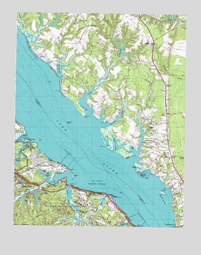
Clay Bank, VA USGS Topographic Map
Click on map above to begin viewing in our Map Viewer.

This topographic map contains these locations and features:
Feature Name Type Latitude Longitude GNIS ID View Map
Aberdeen CreekStreamN37.3363°W76.5922°1462323View Map
Aberdeen LandingLocaleN37.3410°W76.5941°1761538View Map
Abingdon CemeteryCemeteryN37.3326°W76.5133°1761539View Map
Abingdon ChurchChurchN37.3321°W76.5133°1462328View Map
Abingdon DistrictCivilN37.3594°W76.5221°1927074View Map
Abingdon Elementary SchoolSchoolN37.2918°W76.5136°1462330View Map
Abingdon Volunteer Fire and Rescue Station 3BuildingN37.2829°W76.5065°2086280View Map
Abingdon Volunteer Fire and Rescue Station 5BuildingN37.3106°W76.5207°2086282View Map
Antioch ChurchChurchN37.3357°W76.5436°1462503View Map
Beach Grove ChurchChurchN37.3238°W76.5505°1462852View Map
Bellfield Plantation SiteLocaleN37.2688°W76.5705°1779438View Map
Big Mumfort IslandIslandN37.2728°W76.5153°2090486View Map
Black SwampStreamN37.2532°W76.5761°1463509View Map
Blundering PointCapeN37.3138°W76.5738°1463611View Map
BridgesLocaleN37.3204°W76.5319°1463815View Map
Calvary ChurchChurchN37.3290°W76.5147°1464279View Map
Carmines IslandsIslandN37.2804°W76.5325°1464448View Map
Carmines LandingLocaleN37.2851°W76.5344°1492715View Map
Carp CirclePopulated PlaceN37.2507°W76.5655°1464453View Map
Carter CreekStreamN37.3126°W76.5694°1464482View Map
Carters CovePopulated PlaceN37.3375°W76.5719°2090489View Map
Catlett IslandsIslandN37.2982°W76.5533°1464543View Map
Cedar Bush Olivers Landing Boat RampLocaleN37.3111°W76.5566°2518524View Map
Cedarbush CreekStreamN37.3085°W76.5602°1464657View Map
Charles CornerPopulated PlaceN37.2501°W76.6191°1477198View Map
Cheatham AnnexPopulated PlaceN37.2840°W76.5905°1477978View Map
Cheatham DamDamN37.2985°W76.6180°1491056View Map
Cheatham PondReservoirN37.2913°W76.6179°1501980View Map
Chesapeake Marine Training InstituteSchoolN37.3053°W76.5134°2465291View Map
Clay BankPopulated PlaceN37.3506°W76.6072°1492774View Map
Clay Bank AcresPopulated PlaceN37.3533°W76.6103°2090490View Map
Clay Bank LandingLocaleN37.3493°W76.6094°1761546View Map
CloptonPopulated PlaceN37.3457°W76.5397°1477210View Map
Clopton HeightsPopulated PlaceN37.3450°W76.5358°2090491View Map
CokeLocaleN37.3268°W76.5502°1465060View Map
Colonial National Historical ParkwayParkN37.2704°W76.5805°1488852View Map
ConcordPopulated PlaceN37.3635°W76.6186°1477982View Map
Concord (historical)Populated PlaceN37.3624°W76.6116°1761547View Map
Country VillagePopulated PlaceN37.3139°W76.5422°2090492View Map
Creekwood Cove EstatesPopulated PlaceN37.3578°W76.6025°2090493View Map
Deer Cove Golf CourseLocaleN37.2834°W76.5932°2520158View Map
Felgates CreekStreamN37.2740°W76.5858°1466519View Map
Felgates CrossingBridgeN37.2588°W76.5772°1492934View Map
Fields LandingLocaleN37.3024°W76.5308°1761552View Map
Fields Landing Boat RampLocaleN37.3022°W76.5307°2518531View Map
Gloucester Business ParkLocaleN37.3694°W76.5333°2090488View Map
Gloucester ChurchChurchN37.3254°W76.5141°1761557View Map
Gloucester Field CemeteryCemeteryN37.3051°W76.5213°1467165View Map
Gloucester Point DistrictCivilN37.2677°W76.5074°1927329View Map
Gloucester SchoolSchoolN37.3565°W76.5247°1467166View Map
Green PointCapeN37.2963°W76.5577°1467482View Map
Gum ForkPopulated PlaceN37.3668°W76.5705°1477383View Map
Gum PointCapeN37.3279°W76.5911°1467601View Map
Harbor HillsPopulated PlaceN37.2750°W76.5106°2090494View Map
HayesPopulated PlaceN37.2782°W76.5038°1493063View Map
Hayes Stores Shopping CenterLocaleN37.2938°W76.5122°1761566View Map
Haynes DamDamN37.3490°W76.5483°1489863View Map
Haynes PondReservoirN37.3540°W76.5479°1467864View Map
HermitagePopulated PlaceN37.3414°W76.5958°2090495View Map
Hermitage BanksPopulated PlaceN37.3492°W76.6025°2090496View Map
Hipps PondReservoirN37.2754°W76.6192°1468072View Map
Holly Oaks Golf CourseLocaleN37.2605°W76.5517°2520170View Map
Indian Field CreekStreamN37.2688°W76.5566°1468471View Map
Industrial Resource Technology Industrial ParkLocaleN37.3674°W76.5336°2518597View Map
Jones CreekStreamN37.3590°W76.6172°1468840View Map
Jones LakeReservoirN37.3672°W76.6011°2090505View Map
King CreekStreamN37.2757°W76.5819°1469005View Map
Lighthouse Worship CenterChurchN37.3247°W76.5138°2520406View Map
Little Mumfort IslandIslandN37.2636°W76.5122°2090487View Map
MillwoodPopulated PlaceN37.3647°W76.5503°2090497View Map
Mumfort IslandsIslandN37.2693°W76.5141°1471264View Map
Naval Supply Center Cheatham AnnexMilitaryN37.2838°W76.6038°2511944View Map
Naval Weapons Station-Yorktown HelipadAirportN37.2678°W76.5736°1498863View Map
Neva TerracePopulated PlaceN37.2817°W76.5158°2090498View Map
New Life Church of GodChurchN37.3020°W76.5131°2520457View Map
New Quarter Farm AirportAirportN37.3442°W76.5641°2675639View Map
OakdalePopulated PlaceN37.2788°W76.5119°1778970View Map
Oliver LandingLocaleN37.3101°W76.5558°1493374View Map
Olivers EstatesPopulated PlaceN37.3128°W76.5550°2090499View Map
OrdinaryPopulated PlaceN37.3154°W76.5133°1493379View Map
Ordinary Post OfficePost OfficeN37.3170°W76.5139°1761575View Map
Pages Rock LightLocaleN37.3096°W76.5863°1491211View Map
Penniman DamDamN37.2776°W76.5983°1491059View Map
Penniman LakeReservoirN37.2801°W76.6019°1491060View Map
Penniman SpitBarN37.2790°W76.5813°1472187View Map
Piny SwampStreamN37.3326°W76.5244°1472426View Map
Poley PointCapeN37.2743°W76.5833°1472588View Map
Pond Number 10ReservoirN37.2697°W76.6037°1491220View Map
Pond Number 11ReservoirN37.2660°W76.6081°1491221View Map
Pond Number 11 DamDamN37.2685°W76.6097°1491067View Map
Pond Number 11AReservoirN37.2672°W76.6164°1491222View Map
Pond Number 12ReservoirN37.2641°W76.6176°1491223View Map
Poplar CreekStreamN37.2932°W76.5513°1472642View Map
Powhatan PointCapeN37.2882°W76.5366°1761580View Map
Powhatan ShoresPopulated PlaceN37.3314°W76.5881°2090500View Map
Providence CemeteryCemeteryN37.3132°W76.5286°1761581View Map
Providence ChurchChurchN37.3121°W76.5277°1472824View Map
Queen CreekStreamN37.3018°W76.6136°1472898View Map
R and L Mobile Home ParkPopulated PlaceN37.2979°W76.5177°2519936View Map
Ringfield Picnic AreaLocaleN37.2763°W76.5888°1473234View Map
RoanesPopulated PlaceN37.3693°W76.5063°1477687View Map
Robert HeightsPopulated PlaceN37.3483°W76.5386°2090501View Map
Robins DamDamN37.3707°W76.5069°1489865View Map
Robins PondReservoirN37.3724°W76.5108°1502111View Map
Rock ChurchChurchN37.3039°W76.5124°2519792View Map
Roosevelt PondReservoirN37.2515°W76.5440°1473523View Map
Roosevelt Pond DamDamN37.2518°W76.5413°1491069View Map
RosewellPopulated PlaceN37.3310°W76.5894°1477983View Map
Rosewell HarborPopulated PlaceN37.3369°W76.5867°2090502View Map
Rosewell ManorBuildingN37.3276°W76.5763°1761585View Map
Rosewell Memorial GardenCemeteryN37.3160°W76.5308°1761586View Map
Sandy CreekStreamN37.3626°W76.6225°1474016View Map
Sandy PointCapeN37.2671°W76.5502°1474031View Map
Seventeen Plaza Shopping CenterLocaleN37.3205°W76.5131°2519525View Map
Sharps LandingLocaleN37.2640°W76.5855°1779461View Map
Shilsons CornerPopulated PlaceN37.2518°W76.5558°1477748View Map
Smithfield ChurchChurchN37.3693°W76.5738°1474781View Map
Stagecoach Market Shopping CenterLocaleN37.3690°W76.5294°2519530View Map
Timberneck CreekStreamN37.2874°W76.5391°1475730View Map
Town and Country Shopping CenterLocaleN37.3640°W76.5258°1761589View Map
Union Prospect ChurchChurchN37.3704°W76.5338°1476088View Map
United States Naval Supply Center PierLocaleN37.2893°W76.5884°2518584View Map
Victory AcademySchoolN37.2873°W76.5090°2465163View Map
Virginia Marine Police - Middle Area OfficeBuildingN37.3697°W76.5303°2767140View Map
Weaver DamDamN37.3668°W76.6047°1489861View Map
Weaver PondReservoirN37.3716°W76.6068°1489862View Map
White MarshPopulated PlaceN37.3424°W76.5213°1476590View Map
White Marsh Post OfficePost OfficeN37.3392°W76.5196°1761594View Map
White Marsh Shopping CenterLocaleN37.3388°W76.5197°1761595View Map
WicomicoPopulated PlaceN37.2910°W76.5094°1476700View Map
Wicomico Mobile VillagePopulated PlaceN37.2938°W76.5163°2519951View Map
Wicomico Post OfficePost OfficeN37.2921°W76.5189°1761597View Map
Woodberry Farm DamDamN37.3668°W76.6013°1489859View Map
Woodberry Farm PondReservoirN37.3679°W76.5971°1489860View Map
York River PinesPopulated PlaceN37.2564°W76.5039°2090503View Map
York ViewPopulated PlaceN37.3456°W76.5983°2090504View Map

Note: Coordinates in the location and feature list above are referenced to NAD83 datum.


Copyright (C) 2008-2025 Ryan Niemi / Sunset Dynamics ... All Rights Reserved