TopoQuest Logo
Do you find TopoQuest useful?
Help keep TopoQuest running and adding new maps/features by donating!
Bitcoin:  19c7KJd3qBynnjoSw5npx9KScwjBe4ifkT
Litecoin:  LXs6TkuXGGXo1vDsWCkWVdjQX94eUKd6ui
Home View Maps Find Maps Find Places Resources & Links


Caney Creek, Tennessee Topographic Map

USGS Map Title: Caney Creek, TN
USGS Map MRC: 35084A5
DRG (GeoTIFF) Download: o35084a5.tif


Neighboring USGS Topographic Map Quads:


  Benton, TN  
35084B6
 

  Oswald Dome, TN  
35084B5
 

  McFarland, TN  
35084B4
 

  Parksville, TN  
35084A6
 

  Caney Creek, TN  
35084A5
 

  Ducktown, TN  
35084A4
 

  Tennga, GA  
34084H6
 

  Hemp Top, GA  
34084H5
 

  Epworth, GA  
34084H4


Map MRC Location:

N36°
W85°
N36°
W84°
H8 H7 H6 H5 H4 H3 H2 H1
G8 G7 G6 G5 G4 G3 G2 G1
F8 F7 F6 F5 F4 F3 F2 F1
E8 E7 E6 E5 E4 E3 E2 E1
D8 D7 D6 D5 D4 D3 D2 D1
C8 C7 C6 C5 C4 C3 C2 C1
B8 B7 B6 B5 B4 B3 B2 B1
A8 A7 A6 A5 A4 A3 A2 A1
N35°
W85°
N35°
W84°

Caney Creek, TN USGS 1:24K Topographic Map Preview:
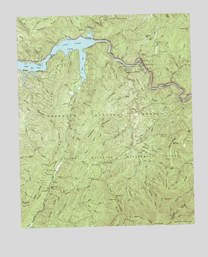
Caney Creek, TN USGS Topographic Map
Click on map above to begin viewing in our Map Viewer.

This topographic map contains these locations and features:
Feature Name Type Latitude Longitude GNIS ID View Map
Bark Legging LeadRidgeN35.0165°W84.5297°1327500View Map
Bearpen HillSummitN35.0184°W84.5569°1327536View Map
Beckler CemeteryCemeteryN35.0815°W84.5833°1327546View Map
Big CreekStreamN35.0381°W84.5352°1327607View Map
Big CreekStreamN35.0951°W84.5469°1327608View Map
Big Creek TrailTrailN35.0212°W84.5297°1327612View Map
Big Frog TrailTrailN35.0173°W84.5205°1327618View Map
Big Frog WildernessReserveN35.0176°W84.5127°330495View Map
Blue Ridge GapGapN35.0240°W84.6035°1327670View Map
Blue Ridge School (historical)SchoolN35.0317°W84.6005°1640650View Map
Blue Ridge TrailTrailN35.0270°W84.6135°1327671View Map
Brown Camp BranchStreamN35.0540°W84.5427°1327716View Map
Camp Cherokee Organization CampLocaleN35.0881°W84.5797°1652423View Map
Caney CreekPopulated PlaceN35.0951°W84.5480°1327814View Map
Caney Creek TrailTrailN35.0748°W84.5608°1327817View Map
Chable (historical)Populated PlaceN35.0431°W84.5930°1640653View Map
Chestnut MountainSummitN35.1156°W84.5010°1327893View Map
Chestnut Mountain TrailTrailN35.0070°W84.5527°1327897View Map
ChimneytopSummitN35.0154°W84.5222°1327915View Map
Civilian Conservation Corps Camp Number 1451 (historical)LocaleN35.1223°W84.5527°1640656View Map
Civilian Conservation Corps Camp Number 1452 (historical)LocaleN35.0265°W84.6013°1640657View Map
Clear CreekStreamN35.1206°W84.5677°1327928View Map
Commissioner District 2CivilN35.1218°W84.5595°2463963View Map
Coon BranchStreamN35.0945°W84.5058°1327967View Map
Coon CreekStreamN35.1223°W84.5583°1327968View Map
Coulter BranchStreamN35.0973°W84.5566°1327980View Map
Curbow CemeteryCemeteryN35.0317°W84.6010°1328009View Map
Dutch CreekStreamN35.0481°W84.5919°1328101View Map
Dutch FieldsFlatN35.0367°W84.5738°1328102View Map
Eaststep GapGapN35.1117°W84.5324°1328118View Map
Fairview ChurchChurchN35.1079°W84.5247°1328160View Map
Fairview School (historical)SchoolN35.1073°W84.5263°1640662View Map
Fall BranchStreamN35.0773°W84.5824°1328167View Map
Fork RidgeRidgeN35.0054°W84.5488°1328211View Map
Fork RidgeRidgeN35.0234°W84.5088°1328212View Map
Fork Ridge TrailTrailN35.0248°W84.5060°1646931View Map
Gate BranchStreamN35.0929°W84.5085°1328251View Map
Goforth CreekStreamN35.0840°W84.5147°1328281View Map
Graham BranchStreamN35.0440°W84.5397°1328294View Map
Grassy GapGapN35.0156°W84.5558°1328303View Map
Grassy Gap TrailTrailN35.0220°W84.5385°1328305View Map
Grassy Gap TrailTrailN35.0317°W84.5238°1328306View Map
Greasy CreekStreamN35.1179°W84.5724°1328320View Map
Groundhog RidgeRidgeN35.0015°W84.5097°1328348View Map
Gunterpole BranchStreamN35.0056°W84.5988°1328359View Map
Haigler BranchStreamN35.0809°W84.5397°1328361View Map
Hand BranchStreamN35.0195°W84.6049°1328381View Map
Haskins CreekStreamN35.0940°W84.6219°1328403View Map
Haskins Ford (historical)CrossingN35.0945°W84.6063°1640665View Map
Hawkins BranchStreamN35.0612°W84.6205°1328410View Map
Hogback MountainSummitN35.0598°W84.5649°1328452View Map
Hogback RidgeRidgeN35.0804°W84.5527°1328453View Map
Hogback TrailTrailN35.0687°W84.5624°1328455View Map
Indian Flat BranchStreamN35.0523°W84.5385°1328525View Map
Indian Flat RidgeRidgeN35.0790°W84.5338°1328526View Map
Indian Flat TrailTrailN35.0812°W84.5333°1328527View Map
Iron Ore BranchStreamN35.0784°W84.5830°1328538View Map
Island CreekStreamN35.0934°W84.6160°1328544View Map
Jake BranchStreamN35.1026°W84.5897°1328552View Map
Johnson BranchStreamN35.1029°W84.5880°1328577View Map
Lake OcoeeReservoirN35.0963°W84.6124°1304751View Map
Laurel BranchStreamN35.0426°W84.5794°1328640View Map
Laurel BranchStreamN35.0681°W84.5388°1328641View Map
Laurel CreekStreamN35.0573°W84.5463°1328650View Map
Left Prong Caney CreekStreamN35.0987°W84.5366°1328672View Map
Licklog RidgeRidgeN35.0079°W84.5135°1326950View Map
Licklog Ridge TrailTrailN35.0087°W84.5072°1328693View Map
Little Caney BranchStreamN35.0981°W84.5499°1328710View Map
Little Fall BranchStreamN35.0592°W84.5885°1328721View Map
Little Sylco BranchStreamN35.0040°W84.6160°1328752View Map
Low GapGapN35.0337°W84.5166°1328790View Map
Low GapGapN35.0548°W84.5041°1328791View Map
Low Gap BranchStreamN35.0390°W84.5374°1328796View Map
Low Gap TrailTrailN35.0384°W84.5210°1328798View Map
Mac Point Recreation AreaParkN35.1120°W84.5883°1328819View Map
Madden BranchStreamN35.1098°W84.5583°1328822View Map
McCroy 4-H CampLocaleN35.1223°W84.5516°1328861View Map
Middle Fork Sheeds CreekStreamN35.0148°W84.5810°1328896View Map
Milan BranchStreamN35.0798°W84.5822°1328903View Map
Mitchell BranchStreamN35.0976°W84.6166°1328935View Map
Mitchell HillIslandN35.0959°W84.6074°1641133View Map
North Fork Sheeds CreekStreamN35.0145°W84.5805°1329026View Map
North Prong Brown Camp BranchStreamN35.0501°W84.5363°1329031View Map
Ocoee FlumeCanalN35.0795°W84.5266°1646939View Map
Ocoee Power Plant Number TwoBuildingN35.0948°W84.5335°1329046View Map
Ocoee Ranger StationLocaleN35.0992°W84.6091°1641132View Map
Ocoee Wildlife Management AreaParkN35.0417°W84.5666°1640943View Map
Ocoee Work CenterLocaleN35.1159°W84.5769°1641137View Map
Old Fairview CemeteryCemeteryN35.1026°W84.5169°1329053View Map
Pace BranchStreamN35.0445°W84.5447°1329074View Map
Pace GapGapN35.0379°W84.5624°1329075View Map
Parker CemeteryCemeteryN35.1059°W84.5058°1641134View Map
Parks BranchStreamN35.0937°W84.5072°1329097View Map
Parksville Boat RampLocaleN35.1087°W84.5958°1646940View Map
Parksville Lake Observation SiteLocaleN35.1142°W84.6160°1641139View Map
Parksville Lake Recreation AreaParkN35.1156°W84.5744°1329098View Map
Peavine MountainSummitN35.0481°W84.5149°1329107View Map
Peavine RidgeRidgeN35.0276°W84.5194°1329108View Map
Peavine RidgeRidgeN35.0492°W84.5149°1329109View Map
Penitentiary BranchStreamN35.0251°W84.5477°1639433View Map
Peter Camp BranchStreamN35.0465°W84.5444°1639438View Map
Peter Hall BranchStreamN35.0984°W84.5552°1639439View Map
Polk CountyCivilN35.1199°W84.5233°1639782View Map
Price CemeteryCemeteryN35.1131°W84.5766°1641136View Map
Right Prong Caney CreekStreamN35.1009°W84.5363°1639600View Map
Rock CreekStreamN35.1179°W84.5735°1639629View Map
Rough Creek TrailTrailN35.0381°W84.5074°1639662View Map
Sheeds Creek Checking StationLocaleN35.0229°W84.6038°1326979View Map
Short CreekStreamN35.0731°W84.5060°1326999View Map
South Fork Sheeds CreekStreamN35.0148°W84.5808°1327071View Map
SylcoPopulated PlaceN35.0340°W84.5985°1327175View Map
Sylco CampgroundLocaleN35.0270°W84.6013°1327176View Map
Sylco CreekStreamN35.0826°W84.5813°1327177View Map
Sylco Creek TrailTrailN35.0945°W84.5660°1646946View Map
Sylco InletBayN35.0965°W84.5774°1327178View Map
Sylco RidgeRidgeN35.0834°W84.5974°1327179View Map
Sylco RidgeRidgeN35.0440°W84.5997°1327180View Map
Tarkiln RidgeRidgeN35.0101°W84.6013°1327184View Map
Tennessee Valley Authority Boating SiteLocaleN35.0990°W84.5380°1641135View Map
Thornburg RidgeRidgeN35.1201°W84.5999°1327211View Map
Thornburg Shooting RangeLocaleN35.1120°W84.5947°1641138View Map
Tollgate BranchStreamN35.0990°W84.6074°1327232View Map
Tolliver Shanty BranchStreamN35.0829°W84.5163°1327233View Map
United States Forest Service Ocoee Work CenterBuildingN35.1168°W84.5760°2654690View Map
United States Forest Service Ranger StationBuildingN35.0995°W84.6093°2654691View Map
Wildcat BranchStreamN35.0895°W84.5135°1327382View Map
Wolf RidgeRidgeN35.0195°W84.5583°1327413View Map
Wolf Ridge TrailTrailN35.0054°W84.5394°1327415View Map
Wolf Ridge TrailTrailN35.0284°W84.5602°1274977View Map
Yellow Stand LeadRidgeN35.0431°W84.5241°1275292View Map
York BranchStreamN35.0034°W84.5897°1304708View Map

Note: Coordinates in the location and feature list above are referenced to NAD83 datum.


Copyright (C) 2008-2024 Ryan Niemi / Sunset Dynamics ... All Rights Reserved