TopoQuest Logo
Do you find TopoQuest useful?
Help keep TopoQuest running and adding new maps/features by donating!
Bitcoin:  19c7KJd3qBynnjoSw5npx9KScwjBe4ifkT
Litecoin:  LXs6TkuXGGXo1vDsWCkWVdjQX94eUKd6ui
Home View Maps Find Maps Find Places Resources & Links


Epworth, Georgia Topographic Map

USGS Map Title: Epworth, GA
USGS Map MRC: 34084H4
DRG (GeoTIFF) Download: o34084h4.tif


Neighboring USGS Topographic Map Quads:


  Caney Creek, TN  
35084A5
 

  Ducktown, TN  
35084A4
 

  Isabella, TN  
35084A3
 

  Hemp Top, GA  
34084H5
 

  Epworth, GA  
34084H4
 

  Mineral Bluff, GA  
34084H3
 

  Dyer Gap, GA  
34084G5
 

  Cashes Valley, GA  
34084G4
 

  Blue Ridge, GA  
34084G3


Map MRC Location:

N35°
W85°
N35°
W84°
H8 H7 H6 H5 H4 H3 H2 H1
G8 G7 G6 G5 G4 G3 G2 G1
F8 F7 F6 F5 F4 F3 F2 F1
E8 E7 E6 E5 E4 E3 E2 E1
D8 D7 D6 D5 D4 D3 D2 D1
C8 C7 C6 C5 C4 C3 C2 C1
B8 B7 B6 B5 B4 B3 B2 B1
A8 A7 A6 A5 A4 A3 A2 A1
N34°
W85°
N34°
W84°

Epworth, GA USGS 1:24K Topographic Map Preview:
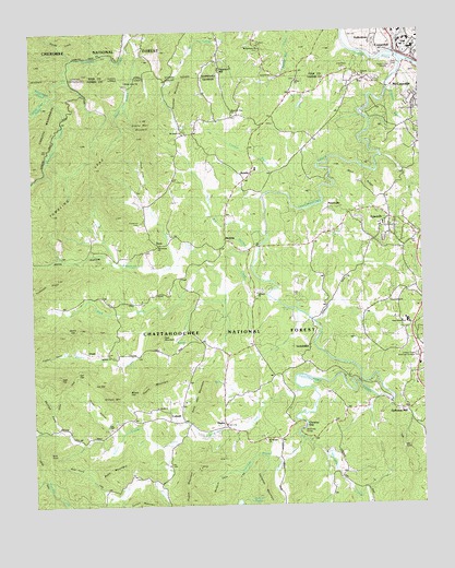
Epworth, GA USGS Topographic Map
Click on map above to begin viewing in our Map Viewer.

This topographic map contains these locations and features:
Feature Name Type Latitude Longitude GNIS ID View Map
Attala Seminary (historical)SchoolN34.9498°W84.3846°351077View Map
Bethel ChurchChurchN34.9870°W84.4146°354636View Map
Browns LakeReservoirN34.9157°W84.4897°336918View Map
Browns Lake DamDamN34.9151°W84.4899°336917View Map
Bruce TopSummitN34.9520°W84.4933°330737View Map
Bryant ProspectMineN34.9279°W84.4519°351080View Map
Buck CreekStreamN34.8806°W84.4594°327258View Map
Buck KnobSummitN34.8890°W84.4958°331264View Map
Buckner MountainRidgeN34.9837°W84.4530°327274View Map
CadLocaleN34.9348°W84.4527°327318View Map
Cad GapGapN34.9101°W84.4858°327319View Map
Callahan BranchStreamN34.8876°W84.4210°327325View Map
Callahan MountainSummitN34.8790°W84.4274°331308View Map
Chastain CemeteryCemeteryN34.9967°W84.4274°1280290View Map
Chestnut GapPopulated PlaceN34.8956°W84.4133°331385View Map
City of CopperhillCivilN34.9947°W84.3861°2404125View Map
ColwellPopulated PlaceN34.8970°W84.4724°331444View Map
Colwell ChurchChurchN34.9006°W84.4599°355252View Map
Cooper Ridge Memorial GardensCemeteryN34.9140°W84.3769°330538View Map
Couch CoveValleyN34.9540°W84.4623°327530View Map
Crestlawn CemeteryCemeteryN34.9899°W84.3988°330537View Map
Damascus ChurchChurchN34.9287°W84.3858°355433View Map
Davis Mill CreekStreamN34.9934°W84.3824°1326925View Map
Dennis GapGapN34.9209°W84.4871°330540View Map
DunnPopulated PlaceN34.9437°W84.4599°331603View Map
Dunn CreekStreamN34.9398°W84.4533°327719View Map
Dunn School (historical)SchoolN34.9426°W84.4608°1730632View Map
Dyer CoveBasinN34.8856°W84.4874°358206View Map
Ellis KnobSummitN34.8901°W84.3824°331653View Map
EpworthPopulated PlaceN34.9506°W84.3849°355715View Map
Epworth CemeteryCemeteryN34.9506°W84.3841°351090View Map
Epworth Census Designated PlaceCensusN34.9510°W84.3808°2587035View Map
Epworth Post OfficePost OfficeN34.9512°W84.3860°2767401View Map
Epworth SchoolSchoolN34.9484°W84.3880°351091View Map
Epworth Seminary (historical)SchoolN34.9490°W84.3871°351092View Map
Epworth United Methodist ChurchChurchN34.9498°W84.3846°351093View Map
Fairview ChurchChurchN34.9881°W84.3935°355766View Map
Fannin County Fire Department Station 5BuildingN34.9410°W84.4262°2604228View Map
Fannin County Fire Department Station 6BuildingN34.8946°W84.4352°2604227View Map
Fightingtown CreekStreamN34.9920°W84.3802°327815View Map
First Baptist Church of EpworthChurchN34.9495°W84.3833°351098View Map
Five Mile Cove BranchStreamN34.9823°W84.4946°327828View Map
Foster HollowValleyN34.8956°W84.4742°327867View Map
FryPopulated PlaceN34.9870°W84.3930°331777View Map
Galloway MillPopulated PlaceN34.9015°W84.3849°331786View Map
Gass CemeteryCemeteryN34.9306°W84.4094°330535View Map
Granny Marr MountainSummitN34.9748°W84.4649°328708View Map
Gravelly Gap School (historical)SchoolN34.9070°W84.3788°351103View Map
Grusher BranchStreamN34.9642°W84.4085°328016View Map
Hells HollowValleyN34.9400°W84.4746°328100View Map
HigdonPopulated PlaceN34.8965°W84.4388°356277View Map
Higdon CoveValleyN34.9153°W84.4907°328146View Map
Higdon CreekStreamN34.9459°W84.4249°326141View Map
High TopSummitN34.9090°W84.4916°328157View Map
Hipp ChapelChurchN34.8954°W84.4749°328170View Map
Hipp SchoolSchoolN34.8920°W84.4755°328171View Map
Horse LeadRidgeN34.9992°W84.4844°1288410View Map
Jeptha Patterson ProspectMineN34.9537°W84.4283°351113View Map
Joe GapGapN34.9070°W84.4805°328330View Map
Johnson FordCrossingN34.9270°W84.4169°1730634View Map
JonestownPopulated PlaceN34.9873°W84.3880°351115View Map
Kellogg ProspectMineN34.9195°W84.4633°351116View Map
KingtownPopulated PlaceN34.9759°W84.3780°351117View Map
Kingtown BranchStreamN34.9840°W84.3849°328411View Map
Lebanon ChurchChurchN34.9306°W84.4283°328469View Map
Lebanon SchoolSchoolN34.9217°W84.4291°328470View Map
LickskilletPopulated PlaceN34.9173°W84.4124°330542View Map
Little Fightingtown CreekStreamN34.9059°W84.4152°328547View Map
Macedonia ChurchChurchN34.9437°W84.4583°330539View Map
MadolaPopulated PlaceN34.9279°W84.4296°332304View Map
Madola Mill CreekStreamN34.9465°W84.4244°327720View Map
Mangum CoveValleyN34.8838°W84.4332°328699View Map
Mary RidgeRidgeN34.9817°W84.4658°330738View Map
Mc Kinney BridgeBridgeN34.8951°W84.4096°330534View Map
McClure CreekStreamN34.8931°W84.4141°328736View Map
Millsap ChurchChurchN34.9148°W84.4730°328810View Map
Millsap MountainSummitN34.9051°W84.4752°332393View Map
Millsaps CemeteryCemeteryN34.9145°W84.4733°351121View Map
Milsap GapGapN34.9051°W84.4699°330544View Map
Mine Number 20MineN34.9756°W84.4219°351122View Map
MobileLocaleN34.9640°W84.4291°328825View Map
Mobile Baptist ChurchChurchN34.9623°W84.4291°351125View Map
Mobile MineMineN34.9623°W84.4188°351126View Map
Mobile School (historical)SchoolN34.9617°W84.4313°351127View Map
Mount Agony ChurchChurchN34.9290°W84.4777°330541View Map
Mount Harmony ChurchChurchN34.9954°W84.4260°1307934View Map
Mount Harmony ChurchChurchN34.9951°W84.4266°325831View Map
Mount Liberty ChurchChurchN34.9729°W84.4513°328877View Map
Mount Moriah ChurchChurchN34.8920°W84.4260°330740View Map
Mount Moriah SchoolSchoolN34.8931°W84.4263°328878View Map
Mount Pisgah ProspectMineN34.8848°W84.4471°351131View Map
Mountain View ChurchChurchN34.9781°W84.4352°328935View Map
OasisPopulated PlaceN34.9154°W84.4821°332552View Map
Pack CreekStreamN34.9256°W84.4583°329120View Map
Pack MountainSummitN34.9198°W84.4594°330545View Map
Patterson CemeteryCemeteryN34.9498°W84.4646°330536View Map
Patterson CreekStreamN34.9329°W84.4399°329139View Map
Patterson Family CemeteryCemeteryN34.9573°W84.4652°351135View Map
Patterson MillPopulated PlaceN34.9906°W84.4396°1315684View Map
Payne MountainSummitN34.9079°W84.4638°330546View Map
Payne ProspectMineN34.9040°W84.4658°351136View Map
Payne SchoolSchoolN34.9742°W84.4513°329150View Map
Phillips CoveValleyN34.8956°W84.4922°328270View Map
PiercevillePopulated PlaceN34.9523°W84.3958°330607View Map
Pisgah MountainSummitN34.8754°W84.4485°332697View Map
Redis MountainSummitN34.8842°W84.4785°332816View Map
Ritchie Church (historical)ChurchN34.9145°W84.4744°351142View Map
Ritchie CreekStreamN34.9465°W84.4246°328147View Map
Ritchie SchoolSchoolN34.9206°W84.4730°329442View Map
Sally Ann MountainSummitN34.9065°W84.4449°329574View Map
Sally Jane ProspectMineN34.9795°W84.4044°351145View Map
Shady Grove ChurchChurchN34.9870°W84.4688°330733View Map
Sholer BranchStreamN34.9998°W84.4685°1303600View Map
Silvermine CreekStreamN34.9829°W84.4930°329708View Map
StaffordtownPopulated PlaceN34.9981°W84.3885°1271194View Map
Tanner ProspectMineN34.9204°W84.4008°351153View Map
Tumbling LeadRidgeN34.9554°W84.4866°330063View Map
Turkeypen RidgeRidgeN34.9342°W84.4958°330077View Map
Watson CreekStreamN34.8898°W84.4580°330178View Map
Weehunt LakeReservoirN34.8752°W84.4349°339716View Map
Wehunt Lake DamDamN34.8767°W84.4333°339715View Map
West Fannin Elementary SchoolSchoolN34.9233°W84.3795°330543View Map
WLSB-AM (Copperhill)TowerN34.9904°W84.3838°1639806View Map
Wolf RidgeRidgeN34.9601°W84.3949°330339View Map

Note: Coordinates in the location and feature list above are referenced to NAD83 datum.


Copyright (C) 2008-2024 Ryan Niemi / Sunset Dynamics ... All Rights Reserved