TopoQuest Logo
Do you find TopoQuest useful?
Help keep TopoQuest running and adding new maps/features by donating!
Bitcoin:  19c7KJd3qBynnjoSw5npx9KScwjBe4ifkT
Litecoin:  LXs6TkuXGGXo1vDsWCkWVdjQX94eUKd6ui
Home View Maps Find Maps Find Places Resources & Links


Knoll Lake, Arizona Topographic Map

USGS Map Title: Knoll Lake, AZ
USGS Map MRC: 34111D1
DRG (GeoTIFF) Download: o34111d1.tif


Neighboring USGS Topographic Map Quads:


  Blue Ridge Reservoir, AZ  
34111E2
 

  Leonard Canyon, AZ  
34111E1
 

  Grama Draw, AZ  
34110E8
 

  Dane Canyon, AZ  
34111D2
 

  Knoll Lake, AZ  
34111D1
 

  Porcupine Ridge, AZ  
34110D8
 

  Diamond Point, AZ  
34111C2
 

  Promontory Butte, AZ  
34111C1
 

  Woods Canyon, AZ  
34110C8


Map MRC Location:

N35°
W112°
N35°
W111°
H8 H7 H6 H5 H4 H3 H2 H1
G8 G7 G6 G5 G4 G3 G2 G1
F8 F7 F6 F5 F4 F3 F2 F1
E8 E7 E6 E5 E4 E3 E2 E1
D8 D7 D6 D5 D4 D3 D2 D1
C8 C7 C6 C5 C4 C3 C2 C1
B8 B7 B6 B5 B4 B3 B2 B1
A8 A7 A6 A5 A4 A3 A2 A1
N34°
W112°
N34°
W111°

Knoll Lake, AZ USGS 1:24K Topographic Map Preview:
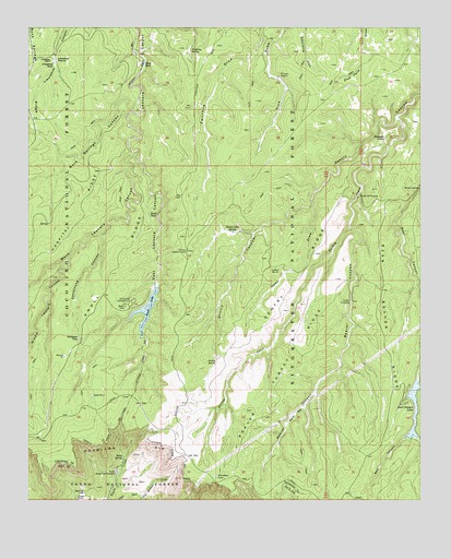
Knoll Lake, AZ USGS Topographic Map
Click on map above to begin viewing in our Map Viewer.

This topographic map contains these locations and features:
Feature Name Type Latitude Longitude GNIS ID View Map
Alcatraz PointCliffN34.4711°W111.0118°25565View Map
Bear Beaver RidgeRidgeN34.4192°W111.0112°26058View Map
Bear CanyonValleyN34.4567°W111.0015°26063View Map
Bear Canyon DamDamN34.4070°W111.0015°37633View Map
Bear Canyon LakeReservoirN34.3935°W111.0032°26072View Map
Bear Canyon Lake Recreation AreaParkN34.4061°W111.0040°37634View Map
Beaver CanyonValleyN34.4467°W111.0229°26145View Map
Beaver ParkFlatN34.3981°W111.0407°26155View Map
Beaver Turkey RidgeRidgeN34.4089°W111.0454°26156View Map
Bench TankReservoirN34.4478°W111.1051°2056535View Map
Besemer CrossingLocaleN34.4420°W111.0640°1853646View Map
Buck Springs CanyonValleyN34.4803°W111.0907°26878View Map
Campo BonitoPopulated PlaceN34.4361°W111.0468°27234View Map
Dines TankReservoirN34.4904°W111.0890°28477View Map
Double CabinLocaleN34.4456°W111.0593°37755View Map
Double Cabin SpringSpringN34.4459°W111.0604°28551View Map
East Leonard CanyonValleyN34.4667°W111.0921°28772View Map
East Leonard Canyon CreekStreamN34.4023°W111.1129°37769View Map
Gentry RidgeRidgeN34.4348°W111.0399°29300View Map
Gentry SpringSpringN34.4114°W111.0657°29301View Map
Gentry TankLocaleN34.3950°W111.0604°37814View Map
Hatchery TrailheadLocaleN34.3784°W111.1001°2056539View Map
Horseshoe LakeLakeN34.3815°W111.0659°30195View Map
Horseshoe VistaLocaleN34.3753°W111.0657°42027View Map
Horton TrailheadLocaleN34.3798°W111.0624°2056540View Map
Hospital TankReservoirN34.4569°W111.1014°2743358View Map
Jake TankReservoirN34.4498°W111.1187°2056534View Map
Jones TankReservoirN34.4692°W111.1176°2056533View Map
Jumping SpringSpringN34.4933°W111.0740°30646View Map
Knoll DamDamN34.4311°W111.0849°37884View Map
Knoll LakeReservoirN34.4256°W111.0881°30804View Map
Knoll Lake Boat LaunchLocaleN34.4314°W111.0859°2670338View Map
Knoll Lake CampgroundLocaleN34.4275°W111.0926°30805View Map
Knoll RidgeRidgeN34.4359°W111.0987°30806View Map
Knoll TankReservoirN34.4508°W111.0871°30807View Map
Lake Number FourLakeN34.4028°W111.1052°32329View Map
Limestone PastureFlatN34.4911°W111.1132°30977View Map
Limestone RanchLocaleN34.4914°W111.1187°30982View Map
Limestone TankReservoirN34.4907°W111.1177°30986View Map
McGuire CrossingCrossingN34.4553°W111.0207°31669View Map
Middle Leonard CanyonValleyN34.4381°W111.1135°31814View Map
Mule CrossingPopulated PlaceN34.4575°W111.0010°32166View Map
O'Haco CabinsLocaleN34.4873°W111.0460°32417View Map
O'Haco Lookout TowerTowerN34.4409°W111.0749°32418View Map
Open DrawValleyN34.4525°W111.0351°32536View Map
Promontory Lookout TowerTowerN34.3770°W111.0224°38013View Map
Rattlesnake RidgeRidgeN34.3898°W111.0307°1853647View Map
Rim TankReservoirN34.3909°W111.1151°2056538View Map
Sandstone CanyonValleyN34.4448°W111.1024°34052View Map
Sandstone TankReservoirN34.4178°W111.1096°34054View Map
Section Thirty-three SpringSpringN34.4770°W111.0840°38063View Map
Tonto SpringSpringN34.3864°W111.0952°35385View Map
Tonto State Fish HatcheryLocaleN34.3828°W111.0979°35388View Map
Tonto TankReservoirN34.3975°W111.0996°2056537View Map
Turkey CreekStreamN34.4759°W111.0079°35539View Map
Turkey CrossingPopulated PlaceN34.4281°W111.0226°35550View Map
Turkey TankReservoirN34.4036°W111.0496°38129View Map
Turkey Tree TankReservoirN34.4034°W111.0489°38131View Map
West Leonard CanyonValleyN34.4667°W111.0915°36003View Map
Whiskey SpringsSpringN34.4509°W111.0179°1853648View Map
Zane Grey LodgeBuildingN34.3767°W111.1076°36501View Map

Note: Coordinates in the location and feature list above are referenced to NAD83 datum.


Copyright (C) 2008-2024 Ryan Niemi / Sunset Dynamics ... All Rights Reserved