TopoQuest Logo
Do you find TopoQuest useful?
Help keep TopoQuest running and adding new maps/features by donating!
Bitcoin:  19c7KJd3qBynnjoSw5npx9KScwjBe4ifkT
Litecoin:  LXs6TkuXGGXo1vDsWCkWVdjQX94eUKd6ui
Home View Maps Find Maps Find Places Resources & Links


Diamond Point, Arizona Topographic Map

USGS Map Title: Diamond Point, AZ
USGS Map MRC: 34111C2
DRG (GeoTIFF) Download: o34111c2.tif


Neighboring USGS Topographic Map Quads:


  Kehl Ridge, AZ  
34111D3
 

  Dane Canyon, AZ  
34111D2
 

  Knoll Lake, AZ  
34111D1
 

  Payson North, AZ  
34111C3
 

  Diamond Point, AZ  
34111C2
 

  Promontory Butte, AZ  
34111C1
 

  Payson South, AZ  
34111B3
 

  McDonald Mountain, AZ  
34111B2
 

  Diamond Butte, AZ  
34111B1


Map MRC Location:

N35°
W112°
N35°
W111°
H8 H7 H6 H5 H4 H3 H2 H1
G8 G7 G6 G5 G4 G3 G2 G1
F8 F7 F6 F5 F4 F3 F2 F1
E8 E7 E6 E5 E4 E3 E2 E1
D8 D7 D6 D5 D4 D3 D2 D1
C8 C7 C6 C5 C4 C3 C2 C1
B8 B7 B6 B5 B4 B3 B2 B1
A8 A7 A6 A5 A4 A3 A2 A1
N34°
W112°
N34°
W111°

Diamond Point, AZ USGS 1:24K Topographic Map Preview:
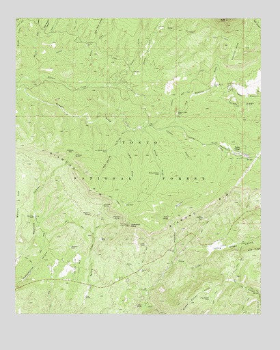
Diamond Point, AZ USGS Topographic Map
Click on map above to begin viewing in our Map Viewer.

This topographic map contains these locations and features:
Feature Name Type Latitude Longitude GNIS ID View Map
Anderson TankReservoirN34.2910°W111.1551°25652View Map
Bonita CreekStreamN34.3489°W111.2399°26594View Map
Box Trap TankReservoirN34.2911°W111.2410°26689View Map
Broad DrawValleyN34.3303°W111.1854°26749View Map
Cabin TankReservoirN34.2794°W111.1846°27152View Map
Cave DrawValleyN34.3217°W111.1974°27381View Map
Cave TankReservoirN34.2962°W111.1947°27388View Map
Diamond PointSummitN34.2875°W111.1929°28458View Map
Diamond Point Lookout TowerTowerN34.2909°W111.1926°39409View Map
Diamond Point ShadowsPopulated PlaceN34.2695°W111.2251°40819View Map
Diamond Point Summer HomesPopulated PlaceN34.3298°W111.1904°40820View Map
Diamond Point TankReservoirN34.3094°W111.1773°28459View Map
Diamond RimRidgeN34.2984°W111.2046°28461View Map
Diamond SpringSpringN34.2910°W111.1970°28463View Map
Ellison Creek EstatesPopulated PlaceN34.3603°W111.1843°40814View Map
Ellison Creek Summer HomesPopulated PlaceN34.3498°W111.1985°40815View Map
Franklin TankReservoirN34.2784°W111.2226°29167View Map
Fuller CreekStreamN34.3667°W111.2401°29226View Map
Gilliland GapGapN34.3167°W111.2229°29325View Map
Gilliland SpringSpringN34.3169°W111.2205°29326View Map
Hells Gate CanyonValleyN34.3661°W111.2090°29866View Map
Hells Gate TrailTrailN34.2667°W111.1399°29868View Map
Hellsgate Fire Department Station 22 Tonto VillageBuildingN34.3175°W111.1361°2672655View Map
Hellsgate Fire Department Station 23 Meads RanchBuildingN34.3455°W111.1418°2672706View Map
Highline National Recreation TrailTrailN34.3673°W111.1551°29972View Map
Jackass TankReservoirN34.2834°W111.2387°39541View Map
Jim Roberts DrawValleyN34.3289°W111.1729°30541View Map
La CienegaPopulated PlaceN34.3734°W111.1757°2044201View Map
Lewis CreekStreamN34.3467°W111.1993°30959View Map
Lion SpringSpringN34.2573°W111.2150°31020View Map
Little Green ValleyValleyN34.2778°W111.1535°31074View Map
Mayberry SpringSpringN34.2922°W111.2126°31604View Map
Mayfield SpringSpringN34.2959°W111.2058°31608View Map
Mead RanchLocaleN34.3392°W111.1474°40821View Map
Mead Ranch Census Designated PlaceCensusN34.3462°W111.1429°2582823View Map
Moore CreekStreamN34.3461°W111.2140°32003View Map
Mud SpringSpringN34.2537°W111.1862°32117View Map
Myrtle PointCliffN34.3742°W111.1454°32224View Map
Neal TankReservoirN34.2816°W111.2072°32260View Map
Oak Spring DrawValleyN34.3298°W111.2024°32465View Map
Oak Spring Draw TankReservoirN34.3192°W111.2039°32466View Map
Perley CreekStreamN34.3559°W111.2385°32804View Map
Pine Thicket TankReservoirN34.2574°W111.1513°32985View Map
Preacher CanyonValleyN34.2706°W111.1707°33188View Map
Pyle RanchLocaleN34.3711°W111.1749°33243View Map
Roberts Draw TankReservoirN34.3349°W111.1685°33677View Map
Roberts MesaSummitN34.3634°W111.1443°33678View Map
Tonto VillagePopulated PlaceN34.3161°W111.1321°35390View Map
Tonto Village Census Designated PlaceCensusN34.3198°W111.1393°2582879View Map
Town of Star ValleyCivilN34.2611°W111.2197°2413328View Map
Walk Moore CanyonValleyN34.3689°W111.2385°35816View Map
Wildcat SpringSpringN34.2907°W111.1757°36188View Map
Yunker Ranch WellWellN34.3464°W111.1499°36495View Map

Note: Coordinates in the location and feature list above are referenced to NAD83 datum.


Copyright (C) 2008-2024 Ryan Niemi / Sunset Dynamics ... All Rights Reserved