TopoQuest Logo
Do you find TopoQuest useful?
Help keep TopoQuest running and adding new maps/features by donating!
Bitcoin:  19c7KJd3qBynnjoSw5npx9KScwjBe4ifkT
Litecoin:  LXs6TkuXGGXo1vDsWCkWVdjQX94eUKd6ui
Home View Maps Find Maps Find Places Resources & Links


La Plata, New Mexico Topographic Map

USGS Map Title: La Plata, NM
USGS Map MRC: 36108H2
DRG (GeoTIFF) Download: o36108h2.tif


Neighboring USGS Topographic Map Quads:


  Red Horse Gulch, CO  
37108A3
 

  Redmesa, CO  
37108A2
 

  Pinkerton Mesa, CO  
37108A1
 

  Purgatory Canyon, NM  
36108H3
 

  La Plata, NM  
36108H2
 

  Adobe Downs Ranch, NM  
36108H1
 

  Youngs Lake, NM  
36108G3
 

  Farmington North, NM  
36108G2
 

  Flora Vista, NM  
36108G1


Map MRC Location:

N37°
W109°
N37°
W108°
H8 H7 H6 H5 H4 H3 H2 H1
G8 G7 G6 G5 G4 G3 G2 G1
F8 F7 F6 F5 F4 F3 F2 F1
E8 E7 E6 E5 E4 E3 E2 E1
D8 D7 D6 D5 D4 D3 D2 D1
C8 C7 C6 C5 C4 C3 C2 C1
B8 B7 B6 B5 B4 B3 B2 B1
A8 A7 A6 A5 A4 A3 A2 A1
N36°
W109°
N36°
W108°

La Plata, NM USGS 1:24K Topographic Map Preview:
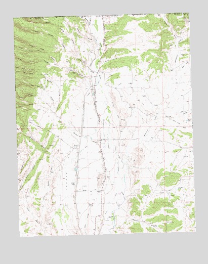
La Plata, NM USGS Topographic Map
Click on map above to begin viewing in our Map Viewer.

This topographic map contains these locations and features:
Feature Name Type Latitude Longitude GNIS ID View Map
Barrel SpringSpringN36.8928°W108.2001°938802View Map
Bill Thomas MineMineN36.9781°W108.1942°916336View Map
Blue LakeReservoirN36.9387°W108.1290°886517View Map
Blue Lake WashStreamN36.9406°W108.1415°899369View Map
Blue Rock DamDamN36.9000°W108.1390°923850View Map
Blue Rock TankReservoirN36.8998°W108.1379°886522View Map
Burt Thomas MineMineN36.9739°W108.2020°916372View Map
Cinder GulchValleyN36.9818°W108.1349°179357View Map
Coalbank CanyonValleyN36.9222°W108.2254°887715View Map
Conger LakeReservoirN36.9045°W108.2092°887786View Map
Conger MesaBenchN36.9133°W108.2148°887787View Map
Craig ArroyoStreamN36.8917°W108.2423°888042View Map
Cunningham DitchCanalN36.9117°W108.1881°888155View Map
Dawson ArroyoStreamN36.9861°W108.1923°179341View Map
Deep Water Well Number 1WellN36.9698°W108.1683°927130View Map
Enterprise DitchCanalN36.9967°W108.1945°888893View Map
Enterprise MineMineN36.9703°W108.2148°916334View Map
Fields MineMineN36.9500°W108.1840°916374View Map
Freedom Baptist ChurchChurchN36.9289°W108.1904°920459View Map
Greenhorn CemeteryCemeteryN36.9400°W108.1725°889604View Map
Greenhorn DitchCanalN36.9450°W108.1790°889605View Map
Hartley WashStreamN36.9400°W108.1504°899413View Map
Helton DitchCanalN36.8922°W108.1854°889892View Map
Highland Park DitchCanalN36.9231°W108.2042°889973View Map
Hillside Thomas DitchCanalN36.9536°W108.1998°890020View Map
Jaquez ArroyoStreamN36.9689°W108.1329°899421View Map
Jones ArroyoStreamN36.9697°W108.2167°890536View Map
Jones MineMineN36.9678°W108.2069°890544View Map
Kempton-PrewittMineN36.9969°W108.1292°916375View Map
La PlataPopulated PlaceN36.9286°W108.1904°890851View Map
La Plata CemeteryCemeteryN36.9076°W108.1872°890852View Map
La Plata Census Designated PlaceCensusN36.9232°W108.1932°2584132View Map
La Plata Indian DitchCanalN36.9531°W108.1926°890833View Map
La Plata MineMineN36.9878°W108.1917°916322View Map
La Plata Post OfficePost OfficeN36.9289°W108.1904°937436View Map
Laplata Post OfficePost OfficeN36.9000°W108.1904°898564View Map
Lefthand DitchCanalN36.9217°W108.1787°891036View Map
Manuel ArroyoStreamN36.9739°W108.1892°891582View Map
McDermott ArroyoStreamN36.9083°W108.1742°899438View Map
McDermott DitchCanalN36.9214°W108.1881°891742View Map
Mefford WashStreamN36.9942°W108.1956°179358View Map
Middle Jones CanyonValleyN36.9794°W108.2267°891952View Map
Morgan MineMineN36.9808°W108.1829°916379View Map
Morgan MinesMineN36.9806°W108.1904°892231View Map
Murphy ArroyoStreamN36.9694°W108.2340°892347View Map
North Buzan CanyonValleyN36.9694°W108.2340°892562View Map
North Jones CanyonValleyN36.9714°W108.2167°892611View Map
North Thomas CanyonValleyN36.9767°W108.2058°179352View Map
Oak Springs CanyonValleyN36.9472°W108.2206°892800View Map
PC-1 Water WellWellN36.9861°W108.1331°926996View Map
Pioneer DitchCanalN36.9889°W108.1848°893324View Map
Pioneer DitchCanalN36.9972°W108.1867°202654View Map
Pruitt MineMineN36.9969°W108.1295°893504View Map
Pump CanyonValleyN36.9467°W108.2248°893549View Map
Ridge Historic SiteLocaleN36.9289°W108.1904°933677View Map
San Juan County Fire District 4 La Plata Station 1BuildingN36.9314°W108.1913°2657835View Map
Silver Pipe DamDamN36.8789°W108.1523°894848View Map
South Buzan CanyonValleyN36.9694°W108.2340°895017View Map
South Jones CanyonValleyN36.9714°W108.2167°895074View Map
South Thomas CanyonValleyN36.9771°W108.2072°895144View Map
Talley TankReservoirN36.9701°W108.2114°895495View Map
Thomas ArroyoStreamN36.9672°W108.1906°895622View Map
Thomas MineMineN36.9775°W108.1862°916389View Map
Thomas MineMineN36.9733°W108.2009°895625View Map
Thompson ArroyoStreamN36.8850°W108.1823°895628View Map
Trail CanyonValleyN36.9450°W108.2220°895790View Map
Tunnel DitchCanalN36.9622°W108.1698°895901View Map
Two Cross ArroyoStreamN36.8956°W108.1748°899480View Map
Two Cross RanchLocaleN36.8844°W108.1862°895982View Map
Walker CanyonValleyN36.9047°W108.2476°896194View Map

Note: Coordinates in the location and feature list above are referenced to NAD83 datum.


Copyright (C) 2008-2025 Ryan Niemi / Sunset Dynamics ... All Rights Reserved