TopoQuest Logo
Do you find TopoQuest useful?
Help keep TopoQuest running and adding new maps/features by donating!
Bitcoin:  19c7KJd3qBynnjoSw5npx9KScwjBe4ifkT
Litecoin:  LXs6TkuXGGXo1vDsWCkWVdjQX94eUKd6ui
Home View Maps Find Maps Find Places Resources & Links


Lake Henry, Minnesota Topographic Map

USGS Map Title: Lake Henry, MN
USGS Map MRC: 45094D7
DRG (GeoTIFF) Download: o45094d7.tif


Neighboring USGS Topographic Map Quads:


  Elrosa, MN  
45094E8
 

  Greenwald, MN  
45094E7
 

  Saint Martin, MN  
45094E6
 

  Georgeville, MN  
45094D8
 

  Lake Henry, MN  
45094D7
 

  Paynesville, MN  
45094D6
 

  New London, MN  
45094C8
 

  Hawick, MN  
45094C7
 

  Lake Koronis, MN  
45094C6


Map MRC Location:

N46°
W95°
N46°
W94°
H8 H7 H6 H5 H4 H3 H2 H1
G8 G7 G6 G5 G4 G3 G2 G1
F8 F7 F6 F5 F4 F3 F2 F1
E8 E7 E6 E5 E4 E3 E2 E1
D8 D7 D6 D5 D4 D3 D2 D1
C8 C7 C6 C5 C4 C3 C2 C1
B8 B7 B6 B5 B4 B3 B2 B1
A8 A7 A6 A5 A4 A3 A2 A1
N45°
W95°
N45°
W94°

Lake Henry, MN USGS 1:24K Topographic Map Preview:
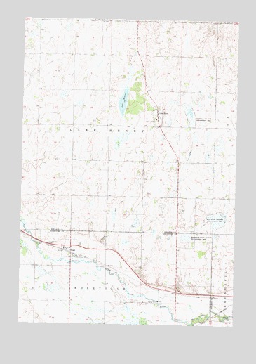
Lake Henry, MN USGS Topographic Map
Click on map above to begin viewing in our Map Viewer.

This topographic map contains these locations and features:
Feature Name Type Latitude Longitude GNIS ID View Map
City of Lake HenryCivilN45.4621°W94.7965°2395591View Map
City of RegalCivilN45.4054°W94.8397°2396344View Map
County Ditch Number FiveCanalN45.4377°W94.7603°642158View Map
Grove CemeteryCemeteryN45.4127°W94.7737°644497View Map
Grove SchoolSchoolN45.4122°W94.7722°644508View Map
Judicial Ditch Number TwoCanalN45.4175°W94.8200°645834View Map
Lake HenryPopulated PlaceN45.4605°W94.7964°646362View Map
Lake HenryLakeN45.4702°W94.8156°644891View Map
Lake Henry Fire DepartmentBuildingN45.4624°W94.7961°2666652View Map
Lake Henry Post Office (historical)Post OfficeN45.4606°W94.7961°2068277View Map
Paynesville CemeteryCemeteryN45.3775°W94.7521°649195View Map
RegalPopulated PlaceN45.4072°W94.8456°649916View Map
Regal (historical)LocaleN45.4050°W94.8500°2067639View Map
Regal Post Office (historical)Post OfficeN45.4072°W94.8453°2067638View Map
Roseville State Wildlife Management AreaParkN45.4108°W94.7797°650301View Map
Saint Anthony CemeteryCemeteryN45.4081°W94.8584°650516View Map
Saint Margaret CemeteryCemeteryN45.4576°W94.7980°650813View Map
Saint Margaret's ParishChurchN45.4592°W94.7964°2068011View Map
Saint Paul's Lutheran CemeteryCemeteryN45.4561°W94.8495°2068093View Map
Township of Lake HenryCivilN45.4561°W94.8246°664681View Map
Zion State Wildlife Management AreaParkN45.4183°W94.7608°654496View Map

Note: Coordinates in the location and feature list above are referenced to NAD83 datum.


Copyright (C) 2008-2024 Ryan Niemi / Sunset Dynamics ... All Rights Reserved