TopoQuest Logo
Do you find TopoQuest useful?
Help keep TopoQuest running and adding new maps/features by donating!
Bitcoin:  19c7KJd3qBynnjoSw5npx9KScwjBe4ifkT
Litecoin:  LXs6TkuXGGXo1vDsWCkWVdjQX94eUKd6ui
Home View Maps Find Maps Find Places Resources & Links


Legareville, South Carolina Topographic Map

USGS Map Title: Legareville, SC
USGS Map MRC: 32080F1
DRG (GeoTIFF) Download: o32080f1.tif


Neighboring USGS Topographic Map Quads:


  Ravenel, SC  
32080G2
 

  Johns Island, SC  
32080G1
 

  Charleston, SC  
32079G8
 

  Wadmalaw Island, SC  
32080F2
 

  Legareville, SC  
32080F1
 

  James Island, SC  
32079F8
 

  Rockville, SC  
32080E2
 

  Kiawah Island, SC  
32080E1


Map MRC Location:

N33°
W81°
N33°
W80°
H8 H7 H6 H5 H4 H3 H2 H1
G8 G7 G6 G5 G4 G3 G2 G1
F8 F7 F6 F5 F4 F3 F2 F1
E8 E7 E6 E5 E4 E3 E2 E1
D8 D7 D6 D5 D4 D3 D2 D1
C8 C7 C6 C5 C4 C3 C2 C1
B8 B7 B6 B5 B4 B3 B2 B1
A8 A7 A6 A5 A4 A3 A2 A1
N32°
W81°
N32°
W80°

Legareville, SC USGS 1:24K Topographic Map Preview:
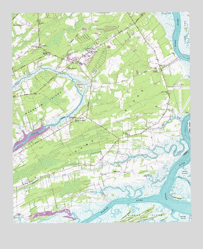
Legareville, SC USGS Topographic Map
Click on map above to begin viewing in our Map Viewer.

This topographic map contains these locations and features:
Feature Name Type Latitude Longitude GNIS ID View Map
Abbapoola CreekStreamN32.6741°W80.0037°1220117View Map
Alligator CreekStreamN32.6530°W80.0156°1220179View Map
Angel Oak Elementary SchoolSchoolN32.7236°W80.1029°1252650View Map
Angel Oak Shopping CenterLocaleN32.7188°W80.0831°1252651View Map
Bass CreekStreamN32.6318°W80.0115°1220347View Map
Bethel Church (historical)ChurchN32.7205°W80.0804°1252685View Map
Big Oaks Hunting ClubLocaleN32.6671°W80.0634°1252688View Map
Blessed Sacrament ChurchChurchN32.6857°W80.0812°1220801View Map
Bloody Dick SwampSwampN32.7341°W80.0945°1252691View Map
Bugby Bridge (historical)BridgeN32.6885°W80.0854°1252704View Map
Burgess Road School (historical)SchoolN32.6546°W80.0959°1252706View Map
Calvary ChurchChurchN32.6877°W80.0787°1221211View Map
Cedar SpringsPopulated PlaceN32.7205°W80.0626°1252729View Map
Chaplin CreekStreamN32.6399°W80.0379°1221509View Map
Charleston Collegiate SchoolSchoolN32.7110°W80.0645°1253226View Map
Charleston Executive AirportAirportN32.6982°W80.0075°1251862View Map
Charleston Fire Department Station 17BuildingN32.7195°W80.0791°2368263View Map
Church BridgeBridgeN32.7146°W80.0915°1252764View Map
Cinder CreekStreamN32.6252°W80.0259°1221598View Map
City of Charleston Fire Department Station 17BuildingN32.7194°W80.0790°2368475View Map
Eden Wind FarmLocaleN32.6850°W80.0625°2652396View Map
Exchange LandingLocaleN32.7216°W80.0081°1252829View Map
Faith ChurchChurchN32.7280°W80.0701°1222349View Map
Fenwick CrossroadsPopulated PlaceN32.7207°W80.0823°1222375View Map
Fenwick HillsPopulated PlaceN32.7349°W80.0737°1252838View Map
Gaud School PlaygroundParkN32.7157°W80.0220°1222666View Map
Green CreekStreamN32.6502°W80.0115°1229751View Map
Haut Gap Middle SchoolSchoolN32.7197°W80.0772°1252934View Map
Holland Island CreekStreamN32.6777°W80.0006°1223225View Map
Hondarosa AirportAirportN32.6855°W80.1062°2650833View Map
Hoopstick IslandIslandN32.7068°W80.0776°1223274View Map
Humber Wood School (historical)SchoolN32.7496°W80.1201°1252937View Map
Humbert WoodsPopulated PlaceN32.7435°W80.1168°1231410View Map
Huskum Corner Cross RoadsPopulated PlaceN32.6752°W80.0504°1252939View Map
Hut CreekStreamN32.6843°W80.0059°1223416View Map
Isinglass SwampSwampN32.7212°W80.1162°1252944View Map
Johns IslandIslandN32.7024°W80.0481°1223592View Map
Johns Island Army Air Field (historical)MilitaryN32.7000°W80.0028°1985996View Map
Johns Island ChurchChurchN32.6866°W80.0823°1252619View Map
Johns Island ChurchChurchN32.7016°W80.0151°1252620View Map
Johns Island ChurchChurchN32.7171°W80.0859°1223594View Map
Johns Island ChurchChurchN32.7241°W80.0745°1223595View Map
Johns Island Community CenterLocaleN32.7285°W80.0687°1223596View Map
Johns Island DivisionCivilN32.6580°W80.0795°1938312View Map
Johns Island Lookout TowerTowerN32.7305°W80.1045°1242427View Map
Johns Island Magistrate OfficeBuildingN32.7264°W80.0976°2490454View Map
Johns Island Post OfficePost OfficeN32.7423°W80.0423°2489849View Map
Kiawah RiverStreamN32.6391°W80.0209°1223727View Map
LegarevillePopulated PlaceN32.6549°W80.0529°1223873View Map
Legareville School (historical)SchoolN32.6546°W80.0545°1252978View Map
Miller HillPopulated PlaceN32.7188°W80.0215°1224569View Map
Miller Hill School (historical)SchoolN32.7182°W80.0215°1253015View Map
Mount Zion Elementary SchoolSchoolN32.6774°W80.0441°1224845View Map
Mullet HallLocaleN32.6299°W80.1223°1224887View Map
Pluff Mud FieldAirportN32.6364°W80.0911°1251864View Map
Point Park EstatesPopulated PlaceN32.7368°W80.1065°1253135View Map
Saint James ChurchChurchN32.6538°W80.0629°1226107View Map
Saint James ChurchChurchN32.7449°W80.1059°1226109View Map
Saint John's Fire Department Station 7BuildingN32.7448°W80.1065°2578710View Map
Saint John's High SchoolSchoolN32.7247°W80.0989°1226162View Map
Saint Johns ChurchChurchN32.7266°W80.0695°1226144View Map
Saint Johns Fire Department Station 1BuildingN32.7285°W80.0664°2368275View Map
Saint Johns Fire Department Station 5BuildingN32.6529°W80.1075°2368287View Map
Saint Matthews ChurchChurchN32.7302°W80.1054°1226212View Map
Saint Stephens African Methodist Episcopal ChurchChurchN32.7430°W80.0406°1253217View Map
Sand Hill School (historical)SchoolN32.6718°W80.1098°1253221View Map
Seven OaksLocaleN32.7382°W80.0329°1253236View Map
Shoreline FarmsPopulated PlaceN32.7277°W80.0190°1253246View Map
Snake IslandIslandN32.6396°W80.0095°1226719View Map
Stafford HeightsPopulated PlaceN32.7210°W80.0715°1253264View Map
Stono RiverStreamN32.6368°W80.0151°1226912View Map
Stono River Stable FarmLocaleN32.6911°W80.0308°2652251View Map
Thumb PointCapeN32.6296°W80.0451°1227124View Map
WYBB-FM (Folly Beach)TowerN32.6660°W80.0529°1252486View Map
Zion ChurchChurchN32.6743°W80.0506°1253347View Map

Note: Coordinates in the location and feature list above are referenced to NAD83 datum.


Copyright (C) 2008-2025 Ryan Niemi / Sunset Dynamics ... All Rights Reserved