TopoQuest Logo
Do you find TopoQuest useful?
Help keep TopoQuest running and adding new maps/features by donating!
Bitcoin:  19c7KJd3qBynnjoSw5npx9KScwjBe4ifkT
Litecoin:  LXs6TkuXGGXo1vDsWCkWVdjQX94eUKd6ui
Home View Maps Find Maps Find Places Resources & Links


Mackay Reservoir, Idaho Topographic Map

USGS Map Title: Mackay Reservoir, ID
USGS Map MRC: 43113H6
DRG (GeoTIFF) Download: o43113h6.tif


Neighboring USGS Topographic Map Quads:


  Elkhorn Creek, ID  
44113A7
 

  Leatherman Peak, ID  
44113A6
 

  Massacre Mountain, ID  
44113A5
 

  Lehman Butte, ID  
43113H7
 

  Mackay Reservoir, ID  
43113H6
 

  Mackay, ID  
43113H5
 

  Copper Basin Knob, ID  
43113G7
 

  Shelly Mountain, ID  
43113G6
 

  Big Blind Canyon, ID  
43113G5


Map MRC Location:

N44°
W114°
N44°
W113°
H8 H7 H6 H5 H4 H3 H2 H1
G8 G7 G6 G5 G4 G3 G2 G1
F8 F7 F6 F5 F4 F3 F2 F1
E8 E7 E6 E5 E4 E3 E2 E1
D8 D7 D6 D5 D4 D3 D2 D1
C8 C7 C6 C5 C4 C3 C2 C1
B8 B7 B6 B5 B4 B3 B2 B1
A8 A7 A6 A5 A4 A3 A2 A1
N43°
W114°
N43°
W113°

Mackay Reservoir, ID USGS 1:24K Topographic Map Preview:
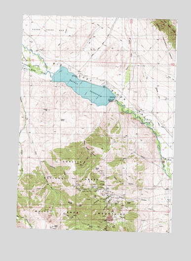
Mackay Reservoir, ID USGS Topographic Map
Click on map above to begin viewing in our Map Viewer.

This topographic map contains these locations and features:
Feature Name Type Latitude Longitude GNIS ID View Map
Battleground (historical)LocaleN43.9610°W113.7014°399431View Map
Battleground CemeteryCemeteryN43.9649°W113.7039°377044View Map
Big Lost River Lower Access AreaLocaleN43.9402°W113.6509°401227View Map
Black Daisy CanyonValleyN43.9474°W113.6847°377744View Map
Blaze CanyonValleyN43.9152°W113.6347°377848View Map
Bullion GulchValleyN43.8955°W113.6697°378490View Map
City SpringSpringN43.9007°W113.6278°379358View Map
Cliff (historical)Populated PlaceN43.8757°W113.6781°396304View Map
Cossack TunnelTunnelN43.8924°W113.6622°379812View Map
Cougar GulchValleyN43.9202°W113.6928°379899View Map
Darlington ShaftMineN43.8816°W113.6778°380252View Map
Dugout HillSummitN43.9446°W113.7278°396422View Map
Dugout SpringSpringN43.9390°W113.7170°380926View Map
East Fork Navarre CreekStreamN43.9352°W113.7453°381143View Map
Empire MineMineN43.8924°W113.6709°381470View Map
Empire Mine Number One - Upper DamDamN43.8916°W113.6709°398892View Map
Empire Mine Number Two DamDamN43.8932°W113.6592°398893View Map
Horseshoe CanyonValleyN43.8960°W113.6750°383414View Map
Horseshoe MineMineN43.8977°W113.6914°383423View Map
Linda's Roost AirportAirportN43.9581°W113.6478°2443845View Map
Mackay DamDamN43.9530°W113.6742°386335View Map
MacKay DamDamN43.9532°W113.6742°398782View Map
Mackay Dam Access AreaLocaleN43.9516°W113.6709°401623View Map
Mackay PeakSummitN43.8894°W113.7009°386336View Map
Mackay ReservoirReservoirN43.9589°W113.7004°386337View Map
Mackay Reservoir Access AreaLocaleN43.9649°W113.7042°400969View Map
Mackay Reservoir Recreation SiteLocaleN43.9599°W113.6767°394694View Map
Middle Fork Navarre CreekStreamN43.9352°W113.7456°386828View Map
Navarre CreekStreamN43.9691°W113.7489°387482View Map
Parsons CreekStreamN43.9669°W113.7292°388236View Map
Pete CreekStreamN43.9732°W113.7317°388355View Map
Pole Stackyard CreekStreamN43.9677°W113.7423°388699View Map
Taylor CanyonValleyN43.9085°W113.6303°391860View Map
Telephone DrawValleyN43.9144°W113.7328°400126View Map
Upper Cedar CreekStreamN43.9574°W113.6709°392622View Map
Warm Springs CreekStreamN43.9655°W113.7289°392888View Map
White KnobSummitN43.8768°W113.7194°393346View Map
White Knob (historical)Populated PlaceN43.8924°W113.6703°399720View Map
Windy DevilSummitN43.9110°W113.6892°398371View Map

Note: Coordinates in the location and feature list above are referenced to NAD83 datum.


Copyright (C) 2008-2025 Ryan Niemi / Sunset Dynamics ... All Rights Reserved