TopoQuest Logo
Do you find TopoQuest useful?
Help keep TopoQuest running and adding new maps/features by donating!
Bitcoin:  19c7KJd3qBynnjoSw5npx9KScwjBe4ifkT
Litecoin:  LXs6TkuXGGXo1vDsWCkWVdjQX94eUKd6ui
Home View Maps Find Maps Find Places Resources & Links


Melrose, Florida Topographic Map

USGS Map Title: Melrose, FL
USGS Map MRC: 29082F1
DRG (GeoTIFF) Download: o29082f1.tif


Neighboring USGS Topographic Map Quads:


  Waldo, FL  
29082G2
 

  Keystone Heights, FL  
29082G1
 

  Gold Head Branch, FL  
29081G8
 

  Orange Heights, FL  
29082F2
 

  Melrose, FL  
29082F1
 

  Putnam Hall, FL  
29081F8
 

  Rochelle, FL  
29082E2
 

  Hawthorne, FL  
29082E1
 

  Keuka, FL  
29081E8


Map MRC Location:

N30°
W83°
N30°
W82°
H8 H7 H6 H5 H4 H3 H2 H1
G8 G7 G6 G5 G4 G3 G2 G1
F8 F7 F6 F5 F4 F3 F2 F1
E8 E7 E6 E5 E4 E3 E2 E1
D8 D7 D6 D5 D4 D3 D2 D1
C8 C7 C6 C5 C4 C3 C2 C1
B8 B7 B6 B5 B4 B3 B2 B1
A8 A7 A6 A5 A4 A3 A2 A1
N29°
W83°
N29°
W82°

Melrose, FL USGS 1:24K Topographic Map Preview:
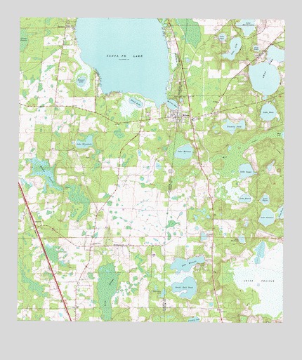
Melrose, FL USGS Topographic Map
Click on map above to begin viewing in our Map Viewer.

This topographic map contains these locations and features:
Feature Name Type Latitude Longitude GNIS ID View Map
BeckhamtownPopulated PlaceN29.6561°W82.0770°295122View Map
Believers Worship Center Church of GodChurchN29.7253°W82.0472°2364131View Map
Black LakeLakeN29.7156°W82.0699°278910View Map
Bonnet LakeLakeN29.7244°W82.0955°279221View Map
CampvillePopulated PlaceN29.6664°W82.1184°295173View Map
Campville Methodist ChurchChurchN29.6641°W82.1187°300405View Map
Church of Christ MelroseChurchN29.7278°W82.0478°2364130View Map
Clearwater LakeLakeN29.6367°W82.0561°280554View Map
Damascus Baptist ChurchChurchN29.6622°W82.1148°300406View Map
EarletonPopulated PlaceN29.7439°W82.1034°294372View Map
Earleton Post OfficePost OfficeN29.7464°W82.1034°2364169View Map
Echo LakeLakeN29.7383°W82.0132°282072View Map
Eden Baptist ChurchChurchN29.6311°W82.0970°282079View Map
Eliam Baptist ChurchChurchN29.7108°W82.0514°2364134View Map
Eliam Cemetery of Melrose FloridaCemeteryN29.7072°W82.0444°2364112View Map
Fawlers PrairieSwampN29.6606°W82.0537°298031View Map
Fowlers LakeLakeN29.6258°W82.0415°282756View Map
Jergans LakeLakeN29.6609°W82.0377°284761View Map
Lake BarcoLakeN29.6760°W82.0085°278102View Map
Lake ElizabethLakeN29.6986°W82.0937°282164View Map
Lake GoodsonLakeN29.6686°W82.0076°283183View Map
Lake HutchinsonLakeN29.7472°W82.0184°284437View Map
Lake LilyLakeN29.7380°W82.0241°285525View Map
Lake MelroseLakeN29.6954°W82.0468°286695View Map
Lake OpalLakeN29.7426°W82.0294°288163View Map
Lake RosaLakeN29.7119°W82.0074°289951View Map
Lake RowanLakeN29.6765°W82.0178°290017View Map
Lake SuggsLakeN29.6879°W82.0179°291789View Map
Lake WhitcombLakeN29.6596°W82.0194°293194View Map
Lake WinnottLakeN29.6490°W82.0455°293413View Map
Levys PrairieSwampN29.6411°W82.0036°285485View Map
Little Melrose Church of Old Regular Baptist Faith and OrderChurchN29.7083°W82.0392°2364138View Map
MelrosePopulated PlaceN29.7094°W82.0498°286690View Map
Melrose BayBayN29.7150°W82.0528°286691View Map
Melrose Church of God of the Mountain AssemblyChurchN29.7075°W82.0608°2364149View Map
Melrose Electric SubstationBuildingN29.7086°W82.0389°2364113View Map
Melrose Elementary SchoolSchoolN29.7086°W82.0434°299080View Map
Melrose Heritage ParkParkN29.7094°W82.0486°2364137View Map
Melrose Post OfficePost OfficeN29.7126°W82.0448°2364132View Map
Melrose United Methodist ChurchChurchN29.7086°W82.0506°2364139View Map
Melrose Volunteer Fire DepartmentBuildingN29.7101°W82.0497°2364136View Map
Melrose Water Association TowerTowerN29.7075°W82.0386°2364114View Map
Mill CreekSwampN29.6898°W82.0224°286883View Map
Morans PrairieSwampN29.6859°W82.1126°287117View Map
Nelson - Starke CemeteryCemeteryN29.6800°W82.1034°287582View Map
Ochwilla Baptist ChurchChurchN29.6302°W82.0293°288048View Map
Ochwilla CemeteryCemeteryN29.6303°W82.0286°2364110View Map
Ochwilla Elementary SchoolSchoolN29.6300°W82.0306°2364109View Map
Orange Creek Camp LakeSwampN29.6387°W82.0825°298032View Map
Orange Creek ChurchChurchN29.6569°W82.0898°288190View Map
Orange Creek Methodist ChurchChurchN29.6305°W82.1015°300431View Map
Putnam County Emergency Medical Services Rescue Station 87BuildingN29.6276°W82.0292°2661729View Map
Putnam County EMS Rescue Unit 7BuildingN29.6275°W82.0292°2364111View Map
Putnam County Library System Melrose Public LibraryBuildingN29.7125°W82.0457°2450784View Map
RexPopulated PlaceN29.6302°W82.0973°295573View Map
Roundup Cowboy ChurchChurchN29.6547°W82.0864°2364189View Map
Saint John CemeteryCemeteryN29.7164°W82.0303°2364129View Map
Saint John Missionary Baptist ChurchChurchN29.7155°W82.0307°290218View Map
Saint Johns CemeteryCemeteryN29.7387°W82.1048°2364150View Map
Sanders Ranch AirportAirportN29.6627°W82.0114°309658View Map
Santa Fe LakeLakeN29.7394°W82.0759°290657View Map
Santa Fe Lake ParkParkN29.7108°W82.0636°2364140View Map
South Bull PondLakeN29.6395°W82.0455°291353View Map
Swan LakeLakeN29.7262°W82.0093°291925View Map
The Flying Horseman Airport (historical)AirportN29.7152°W82.0943°309660View Map
Trinity Episcopal ChurchChurchN29.7100°W82.0489°2364133View Map
Twomile PondLakeN29.7056°W82.0246°292625View Map
Waters CemeteryCemeteryN29.6472°W82.0989°2364190View Map
Whispering Pines Commmunity Mobile Home ParkPopulated PlaceN29.6852°W82.0350°2448198View Map

Note: Coordinates in the location and feature list above are referenced to NAD83 datum.


Copyright (C) 2008-2024 Ryan Niemi / Sunset Dynamics ... All Rights Reserved