TopoQuest Logo
Do you find TopoQuest useful?
Help keep TopoQuest running and adding new maps/features by donating!
Bitcoin:  19c7KJd3qBynnjoSw5npx9KScwjBe4ifkT
Litecoin:  LXs6TkuXGGXo1vDsWCkWVdjQX94eUKd6ui
Home View Maps Find Maps Find Places Resources & Links


Keuka, Florida Topographic Map

USGS Map Title: Keuka, FL
USGS Map MRC: 29081E8
DRG (GeoTIFF) Download: o29081e8.tif


Neighboring USGS Topographic Map Quads:


  Melrose, FL  
29082F1
 

  Putnam Hall, FL  
29081F8
 

  Baywood, FL  
29081F7
 

  Hawthorne, FL  
29082E1
 

  Keuka, FL  
29081E8
 

  Rodman, FL  
29081E7
 

  Citra, FL  
29082D1
 

  Eureka Dam, FL  
29081D8
 

  Lake Delancy, FL  
29081D7


Map MRC Location:

N30°
W82°
N30°
W81°
H8 H7 H6 H5 H4 H3 H2 H1
G8 G7 G6 G5 G4 G3 G2 G1
F8 F7 F6 F5 F4 F3 F2 F1
E8 E7 E6 E5 E4 E3 E2 E1
D8 D7 D6 D5 D4 D3 D2 D1
C8 C7 C6 C5 C4 C3 C2 C1
B8 B7 B6 B5 B4 B3 B2 B1
A8 A7 A6 A5 A4 A3 A2 A1
N29°
W82°
N29°
W81°

Keuka, FL USGS 1:24K Topographic Map Preview:
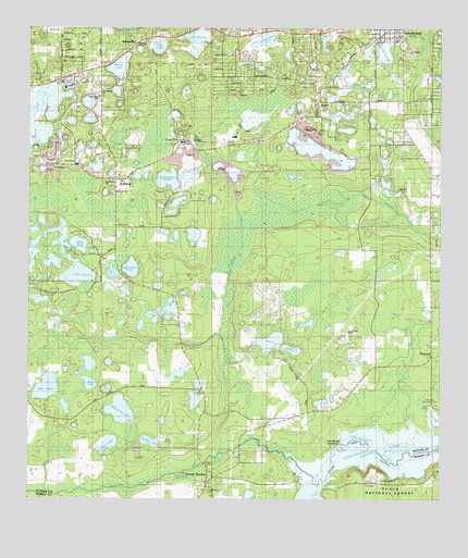
Keuka, FL USGS Topographic Map
Click on map above to begin viewing in our Map Viewer.

This topographic map contains these locations and features:
Feature Name Type Latitude Longitude GNIS ID View Map
Brim PondLakeN29.5365°W81.9754°305379View Map
Bull PondLakeN29.5310°W81.9813°305409View Map
Cabbage CreekStreamN29.5439°W81.9412°305423View Map
Cambo LakeLakeN29.6094°W81.9036°305428View Map
Camp HorizonLocaleN29.5169°W81.9493°306839View Map
Camp KatoriLocaleN29.5164°W81.9668°306838View Map
Camp Ya-Ho-LeLocaleN29.5266°W81.9515°306840View Map
Clear LakeLakeN29.6203°W81.9605°305487View Map
Community Church of GodChurchN29.5753°W81.9739°2357115View Map
Cowpen LakeLakeN29.6026°W81.9997°305516View Map
CrossleyPopulated PlaceN29.5891°W81.9931°305532View Map
Crystal LakeLakeN29.6102°W81.8967°1985669View Map
Darkwater LakeLakeN29.5851°W81.9579°305549View Map
Dowda ParkParkN29.6233°W81.8914°2357150View Map
EdgarPopulated PlaceN29.5950°W81.9506°305624View Map
Edgar Community ChurchChurchN29.5905°W81.9570°305625View Map
Edgar Post OfficePost OfficeN29.5944°W81.9531°2357111View Map
Edgar Water TowerTowerN29.5944°W81.9536°2357110View Map
Faith Baptist ChurchChurchN29.6233°W81.8881°2357136View Map
First Congregational ChurchChurchN29.6242°W81.8894°2357151View Map
Fort Brook LandingPopulated PlaceN29.5147°W81.9076°305692View Map
Fort McCoy OCB Electric SubstationBuildingN29.5897°W81.9897°2357112View Map
Gillis PondLakeN29.5678°W81.9845°305726View Map
Hankley LakeLakeN29.5155°W81.9631°305785View Map
Hewitt LakesLakeN29.5419°W81.9234°305802View Map
Hickory CampLocaleN29.5075°W81.8926°305805View Map
Higginbotham LakeLakeN29.5615°W81.9687°305807View Map
InterlachenPopulated PlaceN29.6239°W81.8904°305857View Map
Interlachen Church of the NazareneChurchN29.5992°W81.8856°2357134View Map
Interlachen Elementary SchoolSchoolN29.6075°W81.8872°2357135View Map
Interlachen Fire DepartmentBuildingN29.6248°W81.8919°2357154View Map
Interlachen Seventh-Day Adventist ChurchChurchN29.5933°W81.8825°2357133View Map
Interlachen Water TowerTowerN29.6222°W81.8958°2357153View Map
Irene M Walker Head Start CenterSchoolN29.6067°W81.9781°2357117View Map
JohnsonPopulated PlaceN29.5847°W81.9731°305875View Map
Johnson CemeteryCemeteryN29.5814°W81.9739°2357116View Map
KeukaPopulated PlaceN29.6047°W81.9126°305906View Map
Keuka CemeteryCemeteryN29.6019°W81.9194°2357109View Map
Key PondLakeN29.5294°W81.9759°305908View Map
Ladys-Slipper LakeLakeN29.6217°W81.9288°305914View Map
Lake ElinLakeN29.6078°W81.8905°1985670View Map
Lake FannyLakeN29.5595°W81.9843°305656View Map
Lake GalileeLakeN29.6223°W81.9487°305714View Map
Lake JunoLakeN29.6074°W81.8950°2746852View Map
Lake KeukaLakeN29.6024°W81.9056°305907View Map
Lake LagondaLakeN29.6189°W81.8919°305916View Map
Lake SusanLakeN29.5298°W81.9942°306469View Map
Lands End RanchPopulated PlaceN29.5430°W81.9020°305928View Map
Little Orange CreekStreamN29.5125°W81.9409°305966View Map
McCarthy LakeLakeN29.5238°W81.9718°306016View Map
Morris LakeLakeN29.6148°W81.9727°306062View Map
Mount Bethel Baptist ChurchChurchN29.6083°W81.9776°306074View Map
Oak Grove School (historical)SchoolN29.6066°W81.9781°306133View Map
Orange CreekStreamN29.5080°W81.9165°306164View Map
Orange SpringsPopulated PlaceN29.5061°W81.9454°306167View Map
Orange Springs CemeteryCemeteryN29.5028°W81.9367°2357131View Map
Orange Springs Community ChurchChurchN29.5036°W81.9367°2357130View Map
Orange Springs ParkParkN29.5044°W81.9372°2357132View Map
Orange Springs Post OfficePost OfficeN29.5032°W81.9463°2357129View Map
Picnic LakeLakeN29.5147°W81.9755°306216View Map
Putnam County Emergency Medical Services Rescue Station 82BuildingN29.6186°W81.8848°2661728View Map
Saint Jude Temple Pentecostal ChurchChurchN29.5997°W81.9775°2357113View Map
Skinner LakeLakeN29.5502°W81.9583°306401View Map
South Atlantic Seventh-Day Adventist CampLocaleN29.6052°W81.9887°306841View Map
The Word of Faith ChurchChurchN29.5861°W81.9725°2357114View Map
Town of InterlachenCivilN29.6203°W81.8963°2405889View Map
WhitevillePopulated PlaceN29.6180°W81.9929°306842View Map
Woodlawn Baptist ChurchChurchN29.5848°W81.9766°306611View Map
Zion Hill Seventh Day Adventist ChurchChurchN29.6124°W81.9897°2448204View Map

Note: Coordinates in the location and feature list above are referenced to NAD83 datum.


Copyright (C) 2008-2024 Ryan Niemi / Sunset Dynamics ... All Rights Reserved