TopoQuest Logo
Do you find TopoQuest useful?
Help keep TopoQuest running and adding new maps/features by donating!
Bitcoin:  19c7KJd3qBynnjoSw5npx9KScwjBe4ifkT
Litecoin:  LXs6TkuXGGXo1vDsWCkWVdjQX94eUKd6ui
Home View Maps Find Maps Find Places Resources & Links


Mount Sizer, California Topographic Map

USGS Map Title: Mount Sizer, CA
USGS Map MRC: 37121B5
DRG (GeoTIFF) Download: o37121b5.tif


Neighboring USGS Topographic Map Quads:


  Lick Observatory, CA  
37121C6
 

  Isabel Valley, CA  
37121C5
 

  Mount Stakes, CA  
37121C4
 

  Morgan Hill, CA  
37121B6
 

  Mount Sizer, CA  
37121B5
 

  Mississippi Creek, CA  
37121B4
 

  Mount Madonna, CA  
37121A6
 

  Gilroy, CA  
37121A5
 

  Gilroy Hot Springs, CA  
37121A4


Map MRC Location:

N38°
W122°
N38°
W121°
H8 H7 H6 H5 H4 H3 H2 H1
G8 G7 G6 G5 G4 G3 G2 G1
F8 F7 F6 F5 F4 F3 F2 F1
E8 E7 E6 E5 E4 E3 E2 E1
D8 D7 D6 D5 D4 D3 D2 D1
C8 C7 C6 C5 C4 C3 C2 C1
B8 B7 B6 B5 B4 B3 B2 B1
A8 A7 A6 A5 A4 A3 A2 A1
N37°
W122°
N37°
W121°

Mount Sizer, CA USGS 1:24K Topographic Map Preview:
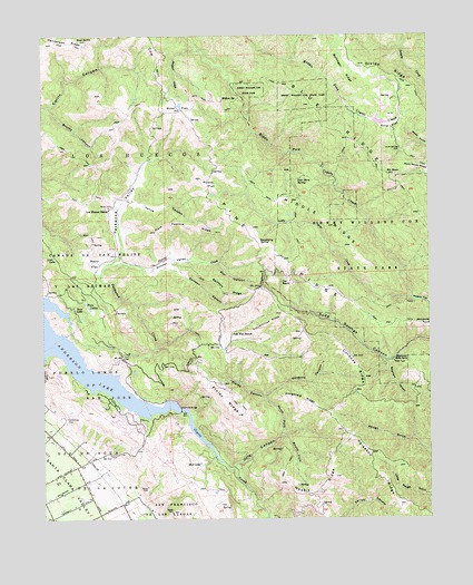
Mount Sizer, CA USGS Topographic Map
Click on map above to begin viewing in our Map Viewer.

This topographic map contains these locations and features:
Feature Name Type Latitude Longitude GNIS ID View Map
Anderson LakeReservoirN37.1709°W121.6194°218262View Map
Blackberry SpringSpringN37.1973°W121.5555°219413View Map
Blue RidgeRidgeN37.2258°W121.5327°233523View Map
Blue RocksSummitN37.2483°W121.6111°219522View Map
Brushy CanyonValleyN37.2316°W121.6233°219940View Map
Clarks CanyonValleyN37.1566°W121.5544°221170View Map
Cochrane BridgeBridgeN37.1533°W121.5811°252015View Map
Coe RanchLocaleN37.1863°W121.5455°221298View Map
Cold FlatFlatN37.2261°W121.5124°221324View Map
Cordoza CanyonValleyN37.1572°W121.5533°221563View Map
Cordoza RidgeRidgeN37.1649°W121.5244°221564View Map
Dairy FlatFlatN37.1913°W121.6088°221976View Map
Deer Horn SpringSpringN37.2129°W121.5422°222190View Map
Diablo Range DivisionCivilN37.2421°W121.5201°1935072View Map
Divide RidgeRidgeN37.2377°W121.5072°222421View Map
Finley RidgeRidgeN37.1558°W121.5663°223510View Map
Fitzgerald RidgeRidgeN37.1555°W121.5419°223560View Map
Henry W. Coe State ParkParkN37.1949°W121.5091°234006View Map
HogsbackRidgeN37.1874°W121.5536°225432View Map
Holiday Lake Golf CourseLocaleN37.1480°W121.5955°1835117View Map
Hoover CreekStreamN37.1911°W121.6044°225548View Map
Hoover ValleyValleyN37.1911°W121.5999°225558View Map
Jackson Elementary SchoolSchoolN37.1376°W121.6056°1835129View Map
Jackson Oaks ParkParkN37.1347°W121.6061°1835130View Map
KSJI-AM (San Martin)TowerN37.1519°W121.5627°1662737View Map
KSQQ-FM (Morgan Hill)TowerN37.1674°W121.5733°1662977View Map
Laurel Spring Club 1624 DamDamN37.2283°W121.5211°1664345View Map
Laurel Springs ClubLocaleN37.2205°W121.5099°226953View Map
Little Coyote CreekStreamN37.1816°W121.5066°227233View Map
Lone LakeLakeN37.1929°W121.6225°227506View Map
Los Huecos RanchLocaleN37.2049°W121.6041°227678View Map
Madrone Soda SpringsSpringN37.1662°W121.5135°227933View Map
Madrone Soda Springs (historical)Populated PlaceN37.1658°W121.5133°1670281View Map
Manzanita PointCapeN37.1744°W121.5008°228043View Map
Mare Pasture RidgeRidgeN37.2011°W121.5783°228082View Map
Middle RidgeRidgeN37.2022°W121.5324°228612View Map
Mount SizerSummitN37.2138°W121.5136°233189View Map
Mud LakeLakeN37.1395°W121.5755°229231View Map
Nesbit RidgeRidgeN37.1324°W121.5366°229472View Map
North Fork Otis CanyonValleyN37.1463°W121.5491°229706View Map
Oak Flat RanchLocaleN37.1727°W121.5644°229847View Map
Otis CanyonValleyN37.1383°W121.5641°230146View Map
Packwood CreekStreamN37.1774°W121.6180°230225View Map
Packwood ValleyValleyN37.1922°W121.6011°230227View Map
Pedrizetti WineryLocaleN37.1305°W121.6247°1835278View Map
Pine RidgeRidgeN37.1938°W121.5499°230717View Map
Poverty FlatFlatN37.1811°W121.5038°231004View Map
Rodeo FlatFlatN37.2116°W121.5713°231803View Map
Samson CanyonValleyN37.1899°W121.5849°232354View Map
Samson RidgeRidgeN37.1833°W121.5661°232355View Map
Santa Clara County Fire Department Dunne Hill Fire StationBuildingN37.1383°W121.6149°2624212View Map
Schoolhouse RidgeRidgeN37.1761°W121.5519°232689View Map
Sizer FlatFlatN37.2311°W121.5811°233188View Map
South Fork Otis CanyonValleyN37.1461°W121.5477°235036View Map
Star CanyonValleyN37.1902°W121.5686°235387View Map
Sulphur CreekStreamN37.2458°W121.5744°235702View Map
Sycamore CanyonValleyN37.1649°W121.5133°235916View Map
Tule LakeLakeN37.1793°W121.6155°236599View Map
Turnbull Learning AcademyLakeN37.1797°W121.6111°236697View Map
Vance CanyonValleyN37.2072°W121.5958°237022View Map
Willow SpringSpringN37.2333°W121.5674°237937View Map

Note: Coordinates in the location and feature list above are referenced to NAD83 datum.


Copyright (C) 2008-2024 Ryan Niemi / Sunset Dynamics ... All Rights Reserved