TopoQuest Logo
Do you find TopoQuest useful?
Help keep TopoQuest running and adding new maps/features by donating!
Bitcoin:  19c7KJd3qBynnjoSw5npx9KScwjBe4ifkT
Litecoin:  LXs6TkuXGGXo1vDsWCkWVdjQX94eUKd6ui
Home View Maps Find Maps Find Places Resources & Links


Mount Madonna, California Topographic Map

USGS Map Title: Mount Madonna, CA
USGS Map MRC: 37121A6
DRG (GeoTIFF) Download: o37121a6.tif


Neighboring USGS Topographic Map Quads:


  Santa Teresa Hills, CA  
37121B7
 

  Morgan Hill, CA  
37121B6
 

  Mount Sizer, CA  
37121B5
 

  Loma Prieta, CA  
37121A7
 

  Mount Madonna, CA  
37121A6
 

  Gilroy, CA  
37121A5
 

  Watsonville West, CA  
36121H7
 

  Watsonville East, CA  
36121H6
 

  Chittenden, CA  
36121H5


Map MRC Location:

N38°
W122°
N38°
W121°
H8 H7 H6 H5 H4 H3 H2 H1
G8 G7 G6 G5 G4 G3 G2 G1
F8 F7 F6 F5 F4 F3 F2 F1
E8 E7 E6 E5 E4 E3 E2 E1
D8 D7 D6 D5 D4 D3 D2 D1
C8 C7 C6 C5 C4 C3 C2 C1
B8 B7 B6 B5 B4 B3 B2 B1
A8 A7 A6 A5 A4 A3 A2 A1
N37°
W122°
N37°
W121°

Mount Madonna, CA USGS 1:24K Topographic Map Preview:
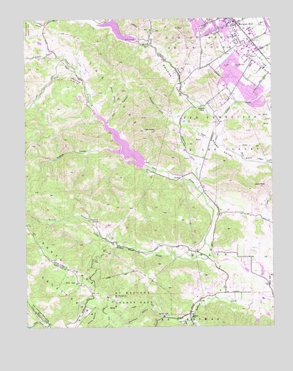
Mount Madonna, CA USGS Topographic Map
Click on map above to begin viewing in our Map Viewer.

This topographic map contains these locations and features:
Feature Name Type Latitude Longitude GNIS ID View Map
Adams SchoolSchoolN37.0305°W121.6566°217978View Map
Barrett Elementary SchoolSchoolN37.1232°W121.6315°2518197View Map
Blackhawk CanyonValleyN37.0044°W121.6838°219419View Map
Bodfish CreekStreamN37.0133°W121.6308°219577View Map
Bradleys StoreLocaleN37.1077°W121.7319°1670271View Map
California Department of Forestry and Fire Protection Station 3 TreehavenBuildingN37.0111°W121.6278°2623674View Map
California Division of ForestryLocaleN37.1091°W121.6380°233608View Map
Caņada GarciaValleyN37.1241°W121.7333°233631View Map
Carrousel CellarsLocaleN37.0419°W121.6286°1834970View Map
Chesbro ReservoirReservoirN37.1227°W121.7108°220969View Map
Debell 628 DamDamN37.0033°W121.6344°1663993View Map
Department of Forestry and Fire Protection South Santa Clara County Fire District Station 1BuildingN37.1102°W121.6380°2623900View Map
Dunn CanyonValleyN37.0883°W121.7052°222730View Map
Eastman CanyonValleyN37.0711°W121.7027°222943View Map
El ToroSummitN37.1205°W121.6722°223063View Map
Elmer J Chesbro 1006 DamDamN37.1159°W121.6948°1664120View Map
Exit 365CrossingN37.1192°W121.6261°2123298View Map
First United Pentecostal ChurchChurchN37.1127°W121.6463°1835062View Map
Fortino WineryLocaleN37.0144°W121.6530°1835068View Map
Gilroy Waterworks Dam (historical)DamN37.0649°W121.6891°1670275View Map
Hay CanyonValleyN37.0836°W121.7083°225043View Map
Hayes CreekStreamN37.0844°W121.6511°225051View Map
Hayes ValleyBasinN37.0716°W121.6516°225058View Map
Hecker Pass WineryLocaleN37.0130°W121.6586°1835109View Map
Hillside Nondenominational ChurchChurchN37.1166°W121.6622°1835113View Map
Howard Wiechert ParkParkN37.0972°W121.6477°1835124View Map
Kirigin CellarsLocaleN37.0472°W121.6522°1835141View Map
Lions PeakSummitN37.0566°W121.6322°227177View Map
Little Arthur CreekStreamN37.0280°W121.6563°227185View Map
Little Uvas CreekStreamN37.1011°W121.7219°227395View Map
Live Oak School (historical)SchoolN37.0133°W121.6466°1670279View Map
Live Oaks WineryLocaleN37.0147°W121.6413°1835156View Map
Llagas-Uvas DivisionCivilN37.0500°W121.7072°1935173View Map
Machado CreekStreamN37.0911°W121.6638°227886View Map
Machado SchoolSchoolN37.0888°W121.6611°227888View Map
Manzanitas School (historical)SchoolN37.0263°W121.7366°1670282View Map
Morgan Hill City HallBuildingN37.1247°W121.6616°1835212View Map
Morgan Hill Community ParkParkN37.1141°W121.6483°1835213View Map
Morgan Hill Police DepartmentBuildingN37.1181°W121.6396°2755746View Map
Morgan Hill Post OfficePost OfficeN37.1205°W121.6465°1835216View Map
Mount Hope CemeteryCemeteryN37.1197°W121.6530°229150View Map
Mount MadonnaSummitN37.0122°W121.7049°227925View Map
Mount Madonna County ParkParkN37.0086°W121.6986°229154View Map
Mount Madonna SchoolSchoolN37.0288°W121.7423°2504475View Map
Murphy CanyonValleyN37.0399°W121.7169°229345View Map
Nob HillSummitN37.1233°W121.6574°1659240View Map
Oak del ParkParkN37.0611°W121.6683°1835251View Map
Oakwood Country SchoolSchoolN37.1038°W121.6330°2518145View Map
Paradise CreekStreamN37.1147°W121.6872°253739View Map
Paradise ParkParkN37.1061°W121.6452°1835270View Map
Paradise ValleyValleyN37.1152°W121.6916°230331View Map
Paradise Valley Elementary SchoolSchoolN37.1068°W121.6474°1835271View Map
R Simoni Irrigation 1622 DamDamN37.0866°W121.7077°1664344View Map
Redwood RetreatLocaleN37.0427°W121.7174°231450View Map
Redwood School (historical)SchoolN37.0341°W121.7091°1670287View Map
Renz GulchValleyN37.0019°W121.6716°231496View Map
Sarahs VineyardLocaleN37.0130°W121.6424°1835358View Map
SolisCivilN37.0224°W121.6524°234873View Map
South Valley Christian ChurchChurchN37.1166°W121.6622°1835377View Map
Sprig LakeReservoirN37.0046°W121.6819°235223View Map
Sprig LakeReservoirN37.0023°W121.6343°1663994View Map
Summerhill VineyardsLocaleN37.0144°W121.6372°1835394View Map
Sycamore CreekStreamN37.0561°W121.6647°1654974View Map
Tennant (historical)Populated PlaceN37.1149°W121.6349°1670294View Map
Tennant Station Shopping CenterLocaleN37.1127°W121.6419°1835409View Map
Thomas Kruse WineryLocaleN37.0130°W121.6491°1835415View Map
Twin PeaksSummitN37.0797°W121.6902°236708View Map
Uvas 1006-002 DamDamN37.0655°W121.6913°1664122View Map
Uvas ReservoirReservoirN37.0733°W121.7006°236945View Map
Uvas School (historical)SchoolN37.0930°W121.7458°1670295View Map
Uvas Volunteer Fire DepartmentBuildingN37.0998°W121.7372°2624222View Map
Vasquez Tree Historical MarkerParkN37.1122°W121.6427°237035View Map
Villa Paradiso VineyardsLocaleN37.0986°W121.6702°1839198View Map
Vineyard Town Center Shopping CenterLocaleN37.1133°W121.6436°1839202View Map

Note: Coordinates in the location and feature list above are referenced to NAD83 datum.


Copyright (C) 2008-2025 Ryan Niemi / Sunset Dynamics ... All Rights Reserved