TopoQuest Logo
Do you find TopoQuest useful?
Help keep TopoQuest running and adding new maps/features by donating!
Bitcoin:  19c7KJd3qBynnjoSw5npx9KScwjBe4ifkT
Litecoin:  LXs6TkuXGGXo1vDsWCkWVdjQX94eUKd6ui
Home View Maps Find Maps Find Places Resources & Links


Painted Rocks Lake, Montana Topographic Map

USGS Map Title: Painted Rocks Lake, MT
USGS Map MRC: 45114F3
DRG (GeoTIFF) Download: o45114f3.tif


Neighboring USGS Topographic Map Quads:


  Mount Jerusalem, MT  
45114G4
 

  Boulder Peak, MT  
45114G3
 

  Piquett Creek, MT  
45114G2
 

  Bare Cone, MT  
45114F4
 

  Painted Rocks Lake, MT  
45114F3
 

  Piquett Mountain, MT  
45114F2
 

  Horse Creek Pass, MT  
45114E4
 

  Alta, MT  
45114E3
 

  Henderson Ridge, ID  
45114E2


Map MRC Location:

N46°
W115°
N46°
W114°
H8 H7 H6 H5 H4 H3 H2 H1
G8 G7 G6 G5 G4 G3 G2 G1
F8 F7 F6 F5 F4 F3 F2 F1
E8 E7 E6 E5 E4 E3 E2 E1
D8 D7 D6 D5 D4 D3 D2 D1
C8 C7 C6 C5 C4 C3 C2 C1
B8 B7 B6 B5 B4 B3 B2 B1
A8 A7 A6 A5 A4 A3 A2 A1
N45°
W115°
N45°
W114°

Painted Rocks Lake, MT USGS 1:24K Topographic Map Preview:
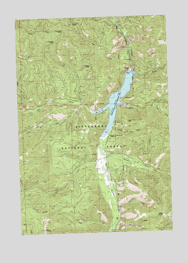
Painted Rocks Lake, MT USGS Topographic Map
Click on map above to begin viewing in our Map Viewer.

This topographic map contains these locations and features:
Feature Name Type Latitude Longitude GNIS ID View Map
Black CreekStreamN45.7444°W114.2915°801881View Map
Blue CreekStreamN45.6616°W114.2681°780138View Map
Blue Joint BayBayN45.6944°W114.3087°801882View Map
Blue Joint CreekStreamN45.6952°W114.3134°780148View Map
Coal CreekStreamN45.6780°W114.3079°781440View Map
Coal Ridge TrailTrailN45.6399°W114.3354°781459View Map
Cow CreekStreamN45.6402°W114.2956°781780View Map
Elk CreekStreamN45.6985°W114.2637°801892View Map
Fourth of July GulchValleyN45.6855°W114.2962°783661View Map
Hot SpringsSpringN45.6966°W114.3645°772581View Map
Little Blue Joint CreekStreamN45.6985°W114.3206°786247View Map
Little Boulder Bay Boat LaunchLocaleN45.7146°W114.2787°768025View Map
Little Boulder Bay CampgroundLocaleN45.7166°W114.2759°794881View Map
Little Boulder CreekStreamN45.7158°W114.2762°786249View Map
Lookout MountainSummitN45.6346°W114.2576°786554View Map
Lookout Mountain TrailTrailN45.6483°W114.2737°786555View Map
Mud CreekStreamN45.7288°W114.2823°787780View Map
Mud Creek SaddleGapN45.7466°W114.3287°806856View Map
Overwhich CreekStreamN45.6749°W114.3073°788536View Map
Painted Rocks Ambulance Quick Response UnitBuildingN45.6303°W114.2949°2637884View Map
Painted Rocks Fire Department and Quick Response UnitBuildingN45.6303°W114.2950°2546598View Map
Painted Rocks LakeReservoirN45.7007°W114.2938°806800View Map
Painted Rocks State Recreation AreaParkN45.6999°W114.2956°768026View Map
Painted Rocks State Recreation AreaLocaleN45.6813°W114.3009°794882View Map
Painted Rocks State Recreation CampgroundLocaleN45.6813°W114.3018°768027View Map
Sand CreekStreamN45.6966°W114.3676°801903View Map
SE SW Section 14 MineMineN45.6560°W114.2809°805084View Map
Slate CreekStreamN45.6988°W114.2865°790636View Map
Slate Creek CampgroundLocaleN45.6980°W114.2829°768028View Map
Slate PointSummitN45.6891°W114.2795°790639View Map
Stevens GulchValleyN45.6252°W114.2951°791501View Map
Took CreekStreamN45.7002°W114.3231°777707View Map
Took Creek SaddleGapN45.7349°W114.3454°801905View Map
Took Ridge SaddleGapN45.7235°W114.3165°806858View Map
Tough Creek SaddleGapN45.7430°W114.3376°801906View Map
West CreekStreamN45.6335°W114.2959°792965View Map
West Fork DamDamN45.7183°W114.2809°793010View Map
West MountainSummitN45.6274°W114.3562°793117View Map

Note: Coordinates in the location and feature list above are referenced to NAD83 datum.


Copyright (C) 2008-2025 Ryan Niemi / Sunset Dynamics ... All Rights Reserved