TopoQuest Logo
Do you find TopoQuest useful?
Help keep TopoQuest running and adding new maps/features by donating!
Bitcoin:  19c7KJd3qBynnjoSw5npx9KScwjBe4ifkT
Litecoin:  LXs6TkuXGGXo1vDsWCkWVdjQX94eUKd6ui
Home View Maps Find Maps Find Places Resources & Links


Palo Verde, California Topographic Map

USGS Map Title: Palo Verde, CA
USGS Map MRC: 33114D6
DRG (GeoTIFF) Download: o33114d6.tif


Neighboring USGS Topographic Map Quads:


  Roosevelt Mine, CA  
33114E7
 

  Ripley, CA  
33114E6
 

  Blythe, CA  
33114E5
 

  Thumb Peak, CA  
33114D7
 

  Palo Verde, CA  
33114D6
 

  Mule Wash, AZ  
33114D5
 

  Palo Verde Peak, CA  
33114C7
 

  Cibola, AZ  
33114C6
 

  Cibola SE, AZ  
33114C5


Map MRC Location:

N34°
W115°
N34°
W114°
H8 H7 H6 H5 H4 H3 H2 H1
G8 G7 G6 G5 G4 G3 G2 G1
F8 F7 F6 F5 F4 F3 F2 F1
E8 E7 E6 E5 E4 E3 E2 E1
D8 D7 D6 D5 D4 D3 D2 D1
C8 C7 C6 C5 C4 C3 C2 C1
B8 B7 B6 B5 B4 B3 B2 B1
A8 A7 A6 A5 A4 A3 A2 A1
N33°
W115°
N33°
W114°

Palo Verde, CA USGS 1:24K Topographic Map Preview:
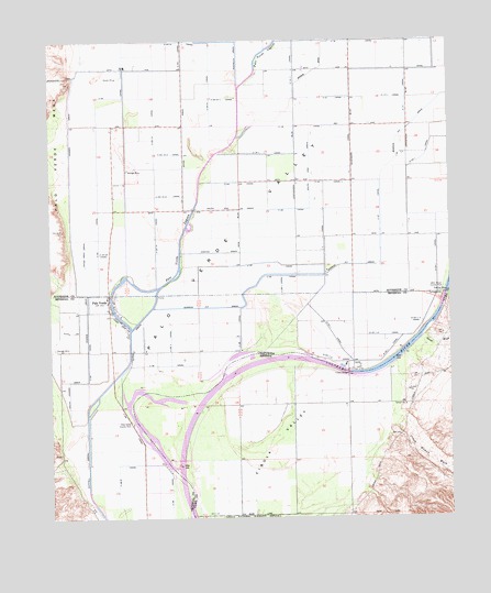
Palo Verde, CA USGS Topographic Map
Click on map above to begin viewing in our Map Viewer.

This topographic map contains these locations and features:
Feature Name Type Latitude Longitude GNIS ID View Map
Browns DrainCanalN33.4920°W114.6675°239732View Map
C-03-10 CanalCanalN33.4503°W114.7175°239928View Map
C-03-10-3 CanalCanalN33.4703°W114.7125°239929View Map
C-03-10-4 CanalCanalN33.4595°W114.7130°239930View Map
C-03-21 CanalCanalN33.4997°W114.7083°239931View Map
C-03-21-1 CanalCanalN33.4847°W114.6952°239932View Map
C-03-22 CanalCanalN33.4445°W114.7338°239933View Map
C-16 CanalCanalN33.4995°W114.6552°239935View Map
C-16-1 CanalCanalN33.4920°W114.6738°239936View Map
C-17 CanalCanalN33.4847°W114.6386°239937View Map
C-17-1 CanalCanalN33.4845°W114.6430°239938View Map
C-18 CanalCanalN33.4775°W114.6727°239939View Map
C-18-1 CanalCanalN33.4700°W114.6822°239940View Map
C-21 CanalCanalN33.4845°W114.6613°239941View Map
C-23 CanalCanalN33.4628°W114.6636°239942View Map
C-24 CanalCanalN33.4556°W114.6750°239943View Map
C-25 CanalCanalN33.4417°W114.6822°270116View Map
C-27 CanalCanalN33.4561°W114.6472°239944View Map
C-28 CanalCanalN33.3811°W114.7136°239945View Map
C-28-1 CanalCanalN33.4359°W114.6777°239946View Map
C-28-2 CanalCanalN33.3886°W114.7302°239947View Map
C-28-3 CanalCanalN33.4217°W114.7127°239948View Map
Cibola BridgeBridgeN33.4128°W114.6577°2928View Map
Cibola BridgeBridgeN33.4131°W114.6577°1868150View Map
Crazy Woman WashStreamN33.3989°W114.6444°3558View Map
D-23-1 CanalCanalN33.4692°W114.6330°241209View Map
D-23-1-3 CanalCanalN33.4261°W114.6363°241210View Map
D-23-1-4 CanalCanalN33.4225°W114.6458°241211View Map
D-23-1-5 CanalCanalN33.4159°W114.6613°241212View Map
Estes DrainCanalN33.4750°W114.7083°242068View Map
Estes West DrainCanalN33.4442°W114.7394°242069View Map
Gould WashStreamN33.4220°W114.6333°5187View Map
Hodges DrainCanalN33.4767°W114.7441°243502View Map
Imperial County Fire Department Station 5BuildingN33.4264°W114.7316°2664581View Map
Imperial County Sheriff's Office Palo Verde StationBuildingN33.4264°W114.7318°2756531View Map
Norton DrainCanalN33.4448°W114.6963°246673View Map
Palo VerdePopulated PlaceN33.4328°W114.7322°247170View Map
Palo Verde Census Designated PlaceCensusN33.4279°W114.7272°2409022View Map
Palo Verde County ParkParkN33.3998°W114.7250°247174View Map
Palo Verde LagoonGutN33.4970°W114.6827°247178View Map
Palo Verde Post OfficePost OfficeN33.4327°W114.7327°2769464View Map
Rannells (historical)Populated PlaceN33.4892°W114.7088°1667794View Map
South End DrainCanalN33.4561°W114.6919°249694View Map
South Hodges DrainCanalN33.4109°W114.7447°249736View Map
Taylor Ferry (historical)CrossingN33.4334°W114.6272°1667826View Map
Thirty Eighth Street County ParkParkN33.4348°W114.6277°250431View Map

Note: Coordinates in the location and feature list above are referenced to NAD83 datum.


Copyright (C) 2008-2025 Ryan Niemi / Sunset Dynamics ... All Rights Reserved