TopoQuest Logo
Do you find TopoQuest useful?
Help keep TopoQuest running and adding new maps/features by donating!
Bitcoin:  19c7KJd3qBynnjoSw5npx9KScwjBe4ifkT
Litecoin:  LXs6TkuXGGXo1vDsWCkWVdjQX94eUKd6ui
Home View Maps Find Maps Find Places Resources & Links


Peach Orchard, Arkansas Topographic Map

USGS Map Title: Peach Orchard, AR
USGS Map MRC: 36090C6
DRG (GeoTIFF) Download: o36090c6.tif


Neighboring USGS Topographic Map Quads:


  Supply, AR  
36090D7
 

  Datto, AR  
36090D6
 

  Corning, AR  
36090D5
 

  Reyno, AR  
36090C7
 

  Peach Orchard, AR  
36090C6
 

  Knobel, AR  
36090C5
 

  O'Kean, AR  
36090B7
 

  Delaplaine, AR  
36090B6
 

  Lafe, AR  
36090B5


Map MRC Location:

N37°
W91°
N37°
W90°
H8 H7 H6 H5 H4 H3 H2 H1
G8 G7 G6 G5 G4 G3 G2 G1
F8 F7 F6 F5 F4 F3 F2 F1
E8 E7 E6 E5 E4 E3 E2 E1
D8 D7 D6 D5 D4 D3 D2 D1
C8 C7 C6 C5 C4 C3 C2 C1
B8 B7 B6 B5 B4 B3 B2 B1
A8 A7 A6 A5 A4 A3 A2 A1
N36°
W91°
N36°
W90°

Peach Orchard, AR USGS 1:24K Topographic Map Preview:
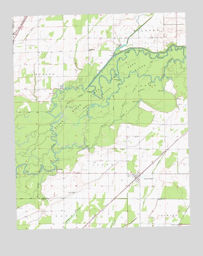
Peach Orchard, AR USGS Topographic Map
Click on map above to begin viewing in our Map Viewer.

This topographic map contains these locations and features:
Feature Name Type Latitude Longitude GNIS ID View Map
Albrite CemeteryCemeteryN36.2631°W90.7484°45803View Map
Allen CemeteryCemeteryN36.3120°W90.6507°45831View Map
Allen LakeLakeN36.3235°W90.6599°75626View Map
Alligator HoleLakeN36.3298°W90.6929°75627View Map
Black River State Game AreaParkN36.3070°W90.7143°76367View Map
BrookingsPopulated PlaceN36.2851°W90.7207°57445View Map
Browns ChapelChurchN36.2712°W90.7079°47019View Map
City of Peach OrchardCivilN36.2813°W90.6611°2404493View Map
Cold Water SloughStreamN36.3148°W90.7126°47911View Map
Cow Ford BendBendN36.3384°W90.6871°82615View Map
Cross SloughStreamN36.3212°W90.7115°48207View Map
Flat LakeLakeN36.3297°W90.6421°75713View Map
Gearharts FieldFlatN36.3215°W90.7262°82623View Map
HeelstringPopulated PlaceN36.3537°W90.6946°57054View Map
High PointCliffN36.3292°W90.7196°50101View Map
Hoisey CemeteryCemeteryN36.3209°W90.6326°50181View Map
Hopewell ChurchChurchN36.3542°W90.6954°82638View Map
Hubble BridgeBridgeN36.2973°W90.6987°50378View Map
Kincaid SloughStreamN36.3128°W90.6759°50845View Map
Little RiverStreamN36.2948°W90.7207°51314View Map
Little River CutoffGutN36.3373°W90.6737°51318View Map
Little River IslandIslandN36.3295°W90.6807°51319View Map
Mill LakeLakeN36.3370°W90.6376°75790View Map
Mollus (historical)Populated PlaceN36.2534°W90.6979°64852View Map
Murphy LakeLakeN36.3555°W90.6722°75796View Map
Murphy Lake DitchCanalN36.3440°W90.6846°52555View Map
Nelson CemeteryCemeteryN36.3578°W90.7390°52606View Map
Nelson School (historical)SchoolN36.3537°W90.7318°82652View Map
Peach OrchardPopulated PlaceN36.2787°W90.6629°77966View Map
Peach Orchard Volunteer Fire Department Station 1BuildingN36.2804°W90.6639°2116946View Map
Petersburg DitchCanalN36.2587°W90.6607°53305View Map
Pirtle ChurchChurchN36.2959°W90.6712°53505View Map
Rankine SloughStreamN36.2978°W90.6982°53896View Map
Roach PointCliffN36.3306°W90.7154°54058View Map
Scott School (historical)SchoolN36.3712°W90.6771°82664View Map
Smithwick School (historical)SchoolN36.3095°W90.6437°82665View Map
Swagger SloughLakeN36.2587°W90.7080°78508View Map
Township of ClarkCivilN36.2857°W90.6981°63717View Map
Township of NelsonCivilN36.3567°W90.7258°63726View Map
Washington School (historical)SchoolN36.3576°W90.6954°82678View Map
Woodland SloughStreamN36.3248°W90.6584°56522View Map

Note: Coordinates in the location and feature list above are referenced to NAD83 datum.


Copyright (C) 2008-2025 Ryan Niemi / Sunset Dynamics ... All Rights Reserved