TopoQuest Logo
Do you find TopoQuest useful?
Help keep TopoQuest running and adding new maps/features by donating!
Bitcoin:  19c7KJd3qBynnjoSw5npx9KScwjBe4ifkT
Litecoin:  LXs6TkuXGGXo1vDsWCkWVdjQX94eUKd6ui
Home View Maps Find Maps Find Places Resources & Links


Pine Grove, Georgia Topographic Map

USGS Map Title: Pine Grove, GA
USGS Map MRC: 31082G4
DRG (GeoTIFF) Download: o31082g4.tif


Neighboring USGS Topographic Map Quads:


  Hazlehurst North, GA  
31082H5
 

  Grays Landing, GA  
31082H4
 

  Baxley NE, GA  
31082H3
 

  Hazlehurst South, GA  
31082G5
 

  Pine Grove, GA  
31082G4
 

  Baxley, GA  
31082G3
 

  Nicholls NE, GA  
31082F5
 

  Alma NW, GA  
31082F4
 

  Alma NE, GA  
31082F3


Map MRC Location:

N32°
W83°
N32°
W82°
H8 H7 H6 H5 H4 H3 H2 H1
G8 G7 G6 G5 G4 G3 G2 G1
F8 F7 F6 F5 F4 F3 F2 F1
E8 E7 E6 E5 E4 E3 E2 E1
D8 D7 D6 D5 D4 D3 D2 D1
C8 C7 C6 C5 C4 C3 C2 C1
B8 B7 B6 B5 B4 B3 B2 B1
A8 A7 A6 A5 A4 A3 A2 A1
N31°
W83°
N31°
W82°

Pine Grove, GA USGS 1:24K Topographic Map Preview:
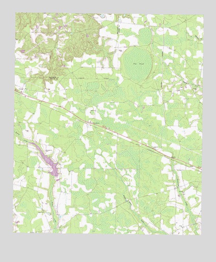
Pine Grove, GA USGS Topographic Map
Click on map above to begin viewing in our Map Viewer.

This topographic map contains these locations and features:
Feature Name Type Latitude Longitude GNIS ID View Map
Appling Pre-Release CenterBuildingN31.8046°W82.4090°2735695View Map
Baxley CemeteryCemeteryN31.7732°W82.3865°349124View Map
Baxley Fellowship ChurchChurchN31.7905°W82.3846°349125View Map
Big Oak ChurchChurchN31.7619°W82.4799°354721View Map
Big PondSwampN31.8465°W82.4181°311406View Map
Bishop Creek Structure Number Seven DamDamN31.7819°W82.4732°340816View Map
Bishop Creek Structure Number Seven LakeReservoirN31.7819°W82.4732°340817View Map
Campground CemeteryCemeteryN31.7969°W82.4787°312270View Map
Consolation Baptist ChurchChurchN31.8131°W82.4478°2502696View Map
Consolidation Missionary Baptist ChurchChurchN31.8130°W82.4479°349188View Map
Crapps CemeteryCemeteryN31.8080°W82.4899°313086View Map
Friendship ChurchChurchN31.7741°W82.3865°355925View Map
Hinsons Still (historical)LocaleN31.8655°W82.4535°335111View Map
Johnson School (historical)SchoolN31.7621°W82.4796°349167View Map
Johnsons Mill (historical)LocaleN31.8730°W82.4396°335116View Map
Lake MayersReservoirN31.7909°W82.4769°349172View Map
Midway Missionary Baptist ChurchChurchN31.8321°W82.3796°318113View Map
Miller LakeReservoirN31.8739°W82.4423°341812View Map
Miller Lake DamDamN31.8735°W82.4432°341811View Map
Oakview ChurchChurchN31.8727°W82.4479°319872View Map
PhillipiPopulated PlaceN31.7549°W82.3871°349186View Map
Phillipi Missionary Baptist ChurchChurchN31.7541°W82.3876°320452View Map
Pine GrovePopulated PlaceN31.8132°W82.4474°326469View Map
PrentissPopulated PlaceN31.7941°W82.3957°332756View Map
Sellers CemeteryCemeteryN31.8541°W82.4279°322708View Map
WBYZ-FM (Baxley)TowerN31.7863°W82.4507°352636View Map
WUFE-AM (Baxley)TowerN31.8002°W82.4110°352367View Map

Note: Coordinates in the location and feature list above are referenced to NAD83 datum.


Copyright (C) 2008-2025 Ryan Niemi / Sunset Dynamics ... All Rights Reserved