TopoQuest Logo
Do you find TopoQuest useful?
Help keep TopoQuest running and adding new maps/features by donating!
Bitcoin:  19c7KJd3qBynnjoSw5npx9KScwjBe4ifkT
Litecoin:  LXs6TkuXGGXo1vDsWCkWVdjQX94eUKd6ui
Home View Maps Find Maps Find Places Resources & Links


Baxley NE, Georgia Topographic Map

USGS Map Title: Baxley NE, GA
USGS Map MRC: 31082H3
DRG (GeoTIFF) Download: o31082h3.tif


Neighboring USGS Topographic Map Quads:


  Alston, GA  
32082A4
 

  Johnson Corner, GA  
32082A3
 

  Reidsville West, GA  
32082A2
 

  Grays Landing, GA  
31082H4
 

  Baxley NE, GA  
31082H3
 

  Altamaha, GA  
31082H2
 

  Pine Grove, GA  
31082G4
 

  Baxley, GA  
31082G3
 

  Altamaha SW, GA  
31082G2


Map MRC Location:

N32°
W83°
N32°
W82°
H8 H7 H6 H5 H4 H3 H2 H1
G8 G7 G6 G5 G4 G3 G2 G1
F8 F7 F6 F5 F4 F3 F2 F1
E8 E7 E6 E5 E4 E3 E2 E1
D8 D7 D6 D5 D4 D3 D2 D1
C8 C7 C6 C5 C4 C3 C2 C1
B8 B7 B6 B5 B4 B3 B2 B1
A8 A7 A6 A5 A4 A3 A2 A1
N31°
W83°
N31°
W82°

Baxley NE, GA USGS 1:24K Topographic Map Preview:
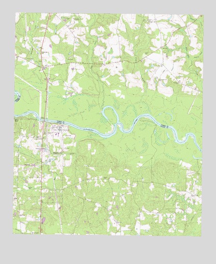
Baxley NE, GA USGS Topographic Map
Click on map above to begin viewing in our Map Viewer.

This topographic map contains these locations and features:
Feature Name Type Latitude Longitude GNIS ID View Map
Altamaha Elementary SchoolSchoolN31.8760°W82.3615°354295View Map
Altamaha River DivisionCivilN31.8780°W82.2702°1936077View Map
Appling County Fire Department Altamaha StationBuildingN31.8758°W82.3628°2604261View Map
Asbury United Methodist ChurchChurchN31.8830°W82.3057°354399View Map
Bay CreekStreamN31.9308°W82.3257°310888View Map
Bell CemeteryCemeteryN31.9241°W82.3410°311043View Map
Benton CemeteryCemeteryN31.9013°W82.3646°311100View Map
Calvary Missionary Baptist ChurchChurchN31.9299°W82.3593°354946View Map
Church of God and ChristChurchN31.9966°W82.3329°312666View Map
Clifton CemeteryCemeteryN31.9777°W82.2887°312748View Map
Cobb CreekStreamN31.9466°W82.3162°355206View Map
Corbetts Chapel (historical)ChurchN31.8969°W82.3729°349141View Map
DavisPopulated PlaceN31.8985°W82.2565°331517View Map
Deen CemeteryCemeteryN31.9352°W82.3707°349145View Map
Deens LandingLocaleN31.9410°W82.3737°349146View Map
English EddyPopulated PlaceN31.9694°W82.3565°326267View Map
English Eddy ChurchChurchN31.9780°W82.3568°313952View Map
Falling RocksPopulated PlaceN31.9402°W82.3732°331693View Map
Georgia Power Plant HatchBuildingN31.9333°W82.3553°2604987View Map
Grace BranchStreamN31.9499°W82.2904°314746View Map
Griner CemeteryCemeteryN31.9969°W82.3410°314925View Map
Hatch Nuclear Power PlantLocaleN31.9342°W82.3444°349161View Map
Inman CreekStreamN31.9741°W82.2571°315926View Map
Joseph Simmons Alexander Senior Memorial BridgeBridgeN31.9396°W82.3548°349169View Map
Lewis LakeReservoirN31.8902°W82.3732°337721View Map
Lewis Lake DamDamN31.8902°W82.3732°337720View Map
Mann-Oquin CemeteryCemeteryN31.9705°W82.3535°345195View Map
Marvey ChurchChurchN31.9810°W82.2771°317754View Map
Marvin Yancey School (historical)SchoolN31.9816°W82.2779°345196View Map
Meltons Chapel United Methodist ChurchChurchN31.8863°W82.3707°318010View Map
Mizpah Baptist ChurchChurchN31.8957°W82.3735°318357View Map
Moody CemeteryCemeteryN31.9077°W82.3151°318413View Map
Oak Grove ChurchChurchN31.9963°W82.2860°319786View Map
Old Campground CemeteryCemeteryN31.9638°W82.2793°319952View Map
Perrys Mill BridgeBridgeN31.9719°W82.3232°345207View Map
Piney BluffCliffN31.9377°W82.3487°349192View Map
Piney Bluff Ferry (historical)CrossingN31.9396°W82.3548°349193View Map
Providence ChurchChurchN31.9616°W82.2660°321191View Map
Riverside Missionary Baptist ChurchChurchN31.8985°W82.2540°349200View Map
Rocky Creek ChurchChurchN31.9955°W82.2854°321830View Map
Sharpes LandingLocaleN31.9441°W82.2851°345212View Map
Smith CemeteryCemeteryN31.9741°W82.3360°323100View Map
Taylor ChapelChurchN31.9744°W82.3665°325810View Map
Williams CreekStreamN31.9594°W82.3557°325350View Map

Note: Coordinates in the location and feature list above are referenced to NAD83 datum.


Copyright (C) 2008-2024 Ryan Niemi / Sunset Dynamics ... All Rights Reserved