TopoQuest Logo
Do you find TopoQuest useful?
Help keep TopoQuest running and adding new maps/features by donating!
Bitcoin:  19c7KJd3qBynnjoSw5npx9KScwjBe4ifkT
Litecoin:  LXs6TkuXGGXo1vDsWCkWVdjQX94eUKd6ui
Home View Maps Find Maps Find Places Resources & Links


Piney Creek, Colorado Topographic Map

USGS Map Title: Piney Creek, CO
USGS Map MRC: 39104E6
DRG (GeoTIFF) Download: o39104e6.tif


Neighboring USGS Topographic Map Quads:


  Fitzsimons, CO  
39104F7
 

  Coal Creek, CO  
39104F6
 

  Watkins, CO  
39104F5
 

  Parker, CO  
39104E7
 

  Piney Creek, CO  
39104E6
 

  Watkins SE, CO  
39104E5
 

  Castle Rock North, CO  
39104D7
 

  Ponderosa Park, CO  
39104D6
 

  Cabin Gulch, CO  
39104D5


Map MRC Location:

N40°
W105°
N40°
W104°
H8 H7 H6 H5 H4 H3 H2 H1
G8 G7 G6 G5 G4 G3 G2 G1
F8 F7 F6 F5 F4 F3 F2 F1
E8 E7 E6 E5 E4 E3 E2 E1
D8 D7 D6 D5 D4 D3 D2 D1
C8 C7 C6 C5 C4 C3 C2 C1
B8 B7 B6 B5 B4 B3 B2 B1
A8 A7 A6 A5 A4 A3 A2 A1
N39°
W105°
N39°
W104°

Piney Creek, CO USGS 1:24K Topographic Map Preview:
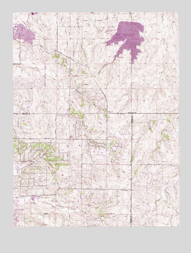
Piney Creek, CO USGS Topographic Map
Click on map above to begin viewing in our Map Viewer.

This topographic map contains these locations and features:
Feature Name Type Latitude Longitude GNIS ID View Map
Antelope Ridge Elementary SchoolSchoolN39.6184°W104.7254°2439178View Map
Aurora Fire Department Station 13BuildingN39.5905°W104.7092°2368799View Map
Aurora Fire Department Station 14BuildingN39.5752°W104.7288°2368701View Map
Aurora Police Department District 3BuildingN39.5903°W104.7084°2369921View Map
Aurora ReservoirReservoirN39.6107°W104.6631°1947706View Map
Ave Maria Catholic SchoolSchoolN39.5201°W104.7162°2730243View Map
Black Forest Hills Elementary SchoolSchoolN39.5851°W104.6946°2730275View Map
Buffalo Trail Elementary SchoolSchoolN39.6212°W104.7046°2730263View Map
Canyon Creek Elementary SchoolSchoolN39.6057°W104.7197°2730184View Map
Cherokee Trail High SchoolSchoolN39.5921°W104.6865°2730227View Map
Cool CreekStreamN39.5217°W104.6389°185055View Map
Coyote Hills Elementary SchoolSchoolN39.5916°W104.7025°2730166View Map
Cunningham Fire Protection District Station 63BuildingN39.6188°W104.7382°2368720View Map
Dove HillPopulated PlaceN39.6206°W104.7119°2354609View Map
Eaglecrest High SchoolSchoolN39.6243°W104.7350°1947710View Map
Everitt AirportAirportN39.5276°W104.6567°204548View Map
Fox Ridge Middle SchoolSchoolN39.5909°W104.6805°2730271View Map
Frontier Valley Elementary SchoolSchoolN39.5021°W104.7145°2439219View Map
Grandview High SchoolSchoolN39.5919°W104.7468°2439167View Map
Homestead HillsPopulated PlaceN39.5314°W104.7297°2354494View Map
Liberty Middle SchoolSchoolN39.5787°W104.7377°2730212View Map
Park ViewPopulated PlaceN39.6128°W104.7497°2354686View Map
ParkboroughPopulated PlaceN39.6114°W104.7397°2354590View Map
Pine ValleyPopulated PlaceN39.5256°W104.7417°2354495View Map
Pine Valley Census Designated PlaceCensusN39.5298°W104.7397°2583282View Map
Pioneer Elementary SchoolSchoolN39.5154°W104.7405°2036538View Map
Pioneer ParkParkN39.6158°W104.7397°2085646View Map
Ponderosa EastPopulated PlaceN39.5461°W104.6705°1947705View Map
Ponderosa East Census Designated PlaceCensusN39.5470°W104.6689°2583283View Map
Ponderosa HillsPopulated PlaceN39.5447°W104.7319°1947704View Map
Ponderosa Hills Census Designated PlaceCensusN39.5428°W104.7280°2583284View Map
SaddlebrookPopulated PlaceN39.5167°W104.7339°2354496View Map
Sampson GulchValleyN39.5853°W104.7155°185054View Map
South Metro Fire Rescue Authority Station 47BuildingN39.5317°W104.6993°2667124View Map
Thunder Ridge Middle SchoolSchoolN39.6214°W104.7369°2439162View Map
Timberline Elementary SchoolSchoolN39.6168°W104.7479°1947707View Map
TravoisPopulated PlaceN39.5658°W104.7394°2354687View Map
University of Phoenix Southlands Learning CenterSchoolN39.6049°W104.7092°2730318View Map
Valley Hope Rehabilitation Center ParkerBuildingN39.5179°W104.7225°2695669View Map

Note: Coordinates in the location and feature list above are referenced to NAD83 datum.


Copyright (C) 2008-2025 Ryan Niemi / Sunset Dynamics ... All Rights Reserved