TopoQuest Logo
Do you find TopoQuest useful?
Help keep TopoQuest running and adding new maps/features by donating!
Bitcoin:  19c7KJd3qBynnjoSw5npx9KScwjBe4ifkT
Litecoin:  LXs6TkuXGGXo1vDsWCkWVdjQX94eUKd6ui
Home View Maps Find Maps Find Places Resources & Links


Piqua, Kansas Topographic Map

USGS Map Title: Piqua, KS
USGS Map MRC: 37095H5
DRG (GeoTIFF) Download: o37095h5.tif


Neighboring USGS Topographic Map Quads:


  Le Roy, KS  
38095A6
 

  Neosho Falls, KS  
38095A5
 

  Geneva, KS  
38095A4
 

  Yates Center, KS  
37095H6
 

  Piqua, KS  
37095H5
 

  Iola, KS  
37095H4
 

  Rose, KS  
37095G6
 

  Yates Center SE, KS  
37095G5
 

  Humboldt, KS  
37095G4


Map MRC Location:

N38°
W96°
N38°
W95°
H8 H7 H6 H5 H4 H3 H2 H1
G8 G7 G6 G5 G4 G3 G2 G1
F8 F7 F6 F5 F4 F3 F2 F1
E8 E7 E6 E5 E4 E3 E2 E1
D8 D7 D6 D5 D4 D3 D2 D1
C8 C7 C6 C5 C4 C3 C2 C1
B8 B7 B6 B5 B4 B3 B2 B1
A8 A7 A6 A5 A4 A3 A2 A1
N37°
W96°
N37°
W95°

Piqua, KS USGS 1:24K Topographic Map Preview:
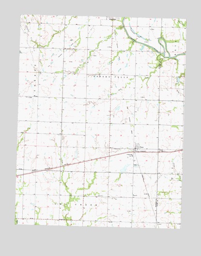
Piqua, KS USGS Topographic Map
Click on map above to begin viewing in our Map Viewer.

This topographic map contains these locations and features:
Feature Name Type Latitude Longitude GNIS ID View Map
AthensPopulated PlaceN37.9070°W95.6139°484689View Map
Clay Bank School (historical)SchoolN37.9795°W95.5819°484225View Map
Enterprise School (historical)SchoolN37.9173°W95.5008°482778View Map
Indian CreekStreamN37.9800°W95.5005°478115View Map
Iola Township CemeteryCemeteryN37.9217°W95.5187°474483View Map
McClannahan School (historical)SchoolN37.9364°W95.6108°484245View Map
Newton School (historical)SchoolN37.8850°W95.5372°484250View Map
PiquaPopulated PlaceN37.9228°W95.5353°474484View Map
Piqua Census Designated PlaceCensusN37.9220°W95.5375°2629168View Map
Piqua Farmers Co - Operative Association Grain Elevator Number 1LocaleN37.9206°W95.5341°2695208View Map
Piqua Fire DepartmentBuildingN37.9212°W95.5352°2695543View Map
Piqua Post OfficePost OfficeN37.9222°W95.5359°2693918View Map
Pleasant Valley School (historical)SchoolN37.8786°W95.5005°482799View Map
Plum Creek School (historical)SchoolN37.8781°W95.5739°484267View Map
Rock CreekStreamN37.9773°W95.5167°474485View Map
Saint Martin's Catholic ChurchChurchN37.9175°W95.5383°2689188View Map
Saint Martin's CemeteryCemeteryN37.9217°W95.5472°474482View Map
Saint Martins SchoolSchoolN37.9181°W95.5386°474481View Map
Schaefer CemeteryCemeteryN37.8784°W95.5919°474479View Map
Spawr School (historical)SchoolN37.9659°W95.5375°484274View Map
Township of Neosho FallsCivilN37.9446°W95.5706°478094View Map
Vernon Oil FieldOilfieldN37.9875°W95.6186°478095View Map
West Liberty School (historical)SchoolN37.9511°W95.5022°482820View Map
Woodson County Improvement DistrictLocaleN37.9229°W95.5483°2692022View Map

Note: Coordinates in the location and feature list above are referenced to NAD83 datum.


Copyright (C) 2008-2024 Ryan Niemi / Sunset Dynamics ... All Rights Reserved