TopoQuest Logo
Do you find TopoQuest useful?
Help keep TopoQuest running and adding new maps/features by donating!
Bitcoin:  19c7KJd3qBynnjoSw5npx9KScwjBe4ifkT
Litecoin:  LXs6TkuXGGXo1vDsWCkWVdjQX94eUKd6ui
Home View Maps Find Maps Find Places Resources & Links


Provencal, Louisiana Topographic Map

USGS Map Title: Provencal, LA
USGS Map MRC: 31093F2
DRG (GeoTIFF) Download: o31093f2.tif


Neighboring USGS Topographic Map Quads:


  Allen, LA  
31093G3
 

  Powhatan, LA  
31093G2
 

  Natchitoches North, LA  
31093G1
 

  Robeline, LA  
31093F3
 

  Provencal, LA  
31093F2
 

  Natchitoches South, LA  
31093F1
 

  Vowells Mill, LA  
31093E3
 

  Bellwood, LA  
31093E2
 

  Flora, LA  
31093E1


Map MRC Location:

N32°
W94°
N32°
W93°
H8 H7 H6 H5 H4 H3 H2 H1
G8 G7 G6 G5 G4 G3 G2 G1
F8 F7 F6 F5 F4 F3 F2 F1
E8 E7 E6 E5 E4 E3 E2 E1
D8 D7 D6 D5 D4 D3 D2 D1
C8 C7 C6 C5 C4 C3 C2 C1
B8 B7 B6 B5 B4 B3 B2 B1
A8 A7 A6 A5 A4 A3 A2 A1
N31°
W94°
N31°
W93°

Provencal, LA USGS 1:24K Topographic Map Preview:
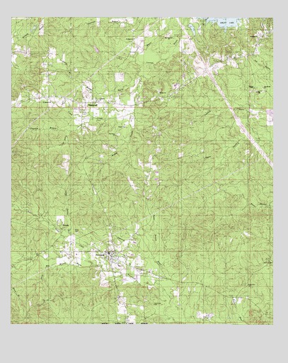
Provencal, LA USGS Topographic Map
Click on map above to begin viewing in our Map Viewer.

This topographic map contains these locations and features:
Feature Name Type Latitude Longitude GNIS ID View Map
Bayou Blue CemeteryCemeteryN31.6407°W93.1368°532458View Map
Beechwood EstatesPopulated PlaceN31.7488°W93.1349°548944View Map
Black BranchStreamN31.6482°W93.2466°533180View Map
Breedlove HillsPopulated PlaceN31.7391°W93.1660°548950View Map
Coal Kiln CreekStreamN31.6482°W93.2466°534010View Map
Coldwater ChurchChurchN31.7160°W93.2085°541636View Map
Dogneck BranchStreamN31.7060°W93.2185°534553View Map
Edmund BayouStreamN31.6429°W93.1738°554344View Map
Emmanuel ChurchChurchN31.7427°W93.1316°534820View Map
Flatwood CreekStreamN31.7107°W93.2113°554435View Map
Foster BranchStreamN31.6532°W93.1832°554462View Map
HagewoodPopulated PlaceN31.7152°W93.2152°540631View Map
Hawthorne CemeteryCemeteryN31.6335°W93.1818°543854View Map
Hawthorne CemeteryCemeteryN31.6335°W93.1821°541637View Map
Indian Spring BranchStreamN31.6618°W93.2216°535931View Map
Junior BranchStreamN31.7263°W93.2224°536141View Map
Knightville (historical)Populated PlaceN31.6849°W93.1363°1630939View Map
Lime Kiln School (historical)SchoolN31.7202°W93.1307°549020View Map
Limekiln ChurchChurchN31.7202°W93.1316°536455View Map
Madden BayouStreamN31.7277°W93.1902°536812View Map
Martin CemeteryCemeteryN31.7060°W93.1960°536917View Map
Mount Olive ChurchChurchN31.7204°W93.1804°537369View Map
Natchitoches Parish Fire Protection District 7 Station 6BuildingN31.7357°W93.2435°2672981View Map
New Beulah ChurchChurchN31.7232°W93.1302°543855View Map
New Beulah ChurchChurchN31.7216°W93.1302°541638View Map
New Testament ChurchChurchN31.7429°W93.1754°537638View Map
Pine Grove ChurchChurchN31.7021°W93.1999°538178View Map
ProvencalPopulated PlaceN31.6529°W93.2021°555734View Map
Provencal Elementary and Junior High SchoolSchoolN31.6540°W93.2034°548902View Map
Provencal Volunteer Fire DepartmentBuildingN31.6517°W93.2022°2672979View Map
Saint Johns CreekStreamN31.7121°W93.1938°538900View Map
Saint Marks ChurchChurchN31.7416°W93.1924°538973View Map
Shamard HeightsPopulated PlaceN31.7454°W93.1446°548920View Map
Shiloh CemeteryCemeteryN31.6624°W93.2182°539338View Map
Stacy Mill BranchStreamN31.6518°W93.2196°539611View Map
Trudo CreekStreamN31.6490°W93.2116°539998View Map
Vascocu CemeteryCemeteryN31.6491°W93.1274°540142View Map
VictoriaPopulated PlaceN31.6641°W93.2254°540156View Map
Village of ProvencalCivilN31.6547°W93.1999°2407532View Map
Walker BranchStreamN31.7118°W93.1935°540191View Map
Williams ChapelChurchN31.7221°W93.1352°540432View Map

Note: Coordinates in the location and feature list above are referenced to NAD83 datum.


Copyright (C) 2008-2024 Ryan Niemi / Sunset Dynamics ... All Rights Reserved