TopoQuest Logo
Do you find TopoQuest useful?
Help keep TopoQuest running and adding new maps/features by donating!
Bitcoin:  19c7KJd3qBynnjoSw5npx9KScwjBe4ifkT
Litecoin:  LXs6TkuXGGXo1vDsWCkWVdjQX94eUKd6ui
Home View Maps Find Maps Find Places Resources & Links


Bellwood, Louisiana Topographic Map

USGS Map Title: Bellwood, LA
USGS Map MRC: 31093E2
DRG (GeoTIFF) Download: o31093e2.tif


Neighboring USGS Topographic Map Quads:


  Robeline, LA  
31093F3
 

  Provencal, LA  
31093F2
 

  Natchitoches South, LA  
31093F1
 

  Vowells Mill, LA  
31093E3
 

  Bellwood, LA  
31093E2
 

  Flora, LA  
31093E1
 

  Peason, LA  
31093D3
 

  Kisatchie, LA  
31093D2
 

  Bayou Livrogne, LA  
31093D1


Map MRC Location:

N32°
W94°
N32°
W93°
H8 H7 H6 H5 H4 H3 H2 H1
G8 G7 G6 G5 G4 G3 G2 G1
F8 F7 F6 F5 F4 F3 F2 F1
E8 E7 E6 E5 E4 E3 E2 E1
D8 D7 D6 D5 D4 D3 D2 D1
C8 C7 C6 C5 C4 C3 C2 C1
B8 B7 B6 B5 B4 B3 B2 B1
A8 A7 A6 A5 A4 A3 A2 A1
N31°
W94°
N31°
W93°

Bellwood, LA USGS 1:24K Topographic Map Preview:
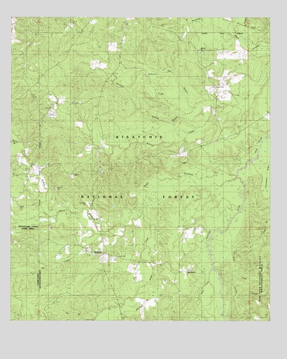
Bellwood, LA USGS Topographic Map
Click on map above to begin viewing in our Map Viewer.

This topographic map contains these locations and features:
Feature Name Type Latitude Longitude GNIS ID View Map
Antioch CemeteryCemeteryN31.5543°W93.2285°541639View Map
Antioch CemeteryCemeteryN31.5041°W93.2282°548189View Map
Antioch ChurchChurchN31.5535°W93.2277°546977View Map
Antioch ChurchChurchN31.5599°W93.2196°541640View Map
Batina BranchStreamN31.5732°W93.2454°547000View Map
Bayou de MuseStreamN31.5427°W93.2324°547003View Map
Bayou SantabarbStreamN31.5604°W93.1404°553520View Map
Beasley CrossingCrossingN31.5674°W93.1310°553551View Map
BellwoodPopulated PlaceN31.5274°W93.2054°547053View Map
Bellwood BranchStreamN31.5255°W93.1843°547054View Map
Blue Spring School (historical)SchoolN31.5743°W93.1527°548948View Map
Bobs CreekStreamN31.5307°W93.1432°547111View Map
Clear BranchStreamN31.5157°W93.1563°547222View Map
Cunningham BrakeSwampN31.5644°W93.1260°547272View Map
Dry BranchStreamN31.5916°W93.1543°547314View Map
Dry CreekStreamN31.5355°W93.2060°547323View Map
Foshee CemeteryCemeteryN31.5466°W93.2454°547372View Map
Friendship CemeteryCemeteryN31.6013°W93.1849°547380View Map
Gibbs SloughGutN31.5749°W93.1296°547393View Map
Gin BranchStreamN31.5032°W93.2074°547395View Map
Hardamon CemeteryCemeteryN31.5482°W93.2135°547436View Map
Harmony ChurchChurchN31.6110°W93.1596°547441View Map
Hickory Grove ChurchChurchN31.5602°W93.2449°547461View Map
Hickoryville Grove Church (historical)ChurchN31.5932°W93.2166°549004View Map
Horsepen CreekStreamN31.5868°W93.1624°547479View Map
Jackson CemeteryCemeteryN31.5649°W93.1674°547516View Map
Longville Lake DamDamN31.5882°W93.2424°556938View Map
Middle CreekStreamN31.5513°W93.1841°547689View Map
Moss CemeteryCemeteryN31.5257°W93.1982°547741View Map
Moss CouleeStreamN31.5316°W93.1560°547742View Map
Mount Nebo ChurchChurchN31.5888°W93.2193°547750View Map
Roberts CemeteryCemeteryN31.5963°W93.1521°547899View Map
Shady Grove ChurchChurchN31.5193°W93.1654°547987View Map
Stanley BranchStreamN31.5199°W93.1421°548031View Map
Sulphur BranchStreamN31.5916°W93.1543°548048View Map

Note: Coordinates in the location and feature list above are referenced to NAD83 datum.


Copyright (C) 2008-2025 Ryan Niemi / Sunset Dynamics ... All Rights Reserved