TopoQuest Logo
Do you find TopoQuest useful?
Help keep TopoQuest running and adding new maps/features by donating!
Bitcoin:  19c7KJd3qBynnjoSw5npx9KScwjBe4ifkT
Litecoin:  LXs6TkuXGGXo1vDsWCkWVdjQX94eUKd6ui
Home View Maps Find Maps Find Places Resources & Links


Ropers Crossroads, South Carolina Topographic Map

USGS Map Title: Ropers Crossroads, SC
USGS Map MRC: 33081F8
DRG (GeoTIFF) Download: o33081f8.tif


Neighboring USGS Topographic Map Quads:


  Red Hill, SC  
33082G1
 

  Edgefield, SC  
33081G8
 

  Johnston, SC  
33081G7
 

  Colliers, SC  
33082F1
 

  Ropers Crossroads, SC  
33081F8
 

  Trenton, SC  
33081F7
 

  Martinez, GA  
33082E1
 

  North Augusta, SC  
33081E8
 

  Graniteville, SC  
33081E7


Map MRC Location:

N34°
W82°
N34°
W81°
H8 H7 H6 H5 H4 H3 H2 H1
G8 G7 G6 G5 G4 G3 G2 G1
F8 F7 F6 F5 F4 F3 F2 F1
E8 E7 E6 E5 E4 E3 E2 E1
D8 D7 D6 D5 D4 D3 D2 D1
C8 C7 C6 C5 C4 C3 C2 C1
B8 B7 B6 B5 B4 B3 B2 B1
A8 A7 A6 A5 A4 A3 A2 A1
N33°
W82°
N33°
W81°

Ropers Crossroads, SC USGS 1:24K Topographic Map Preview:
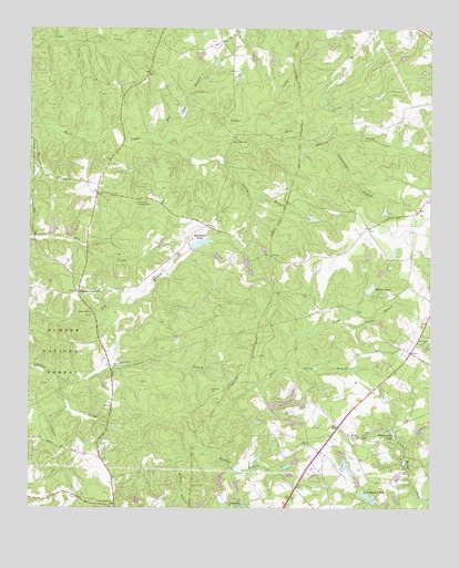
Ropers Crossroads, SC USGS Topographic Map
Click on map above to begin viewing in our Map Viewer.

This topographic map contains these locations and features:
Feature Name Type Latitude Longitude GNIS ID View Map
Arrowhead LakesReservoirN33.6265°W81.8915°1229359View Map
Bakers BranchStreamN33.6365°W81.9543°1244949View Map
Burkhalter BranchStreamN33.6601°W81.9918°1229489View Map
Canaan BranchStreamN33.6735°W81.9040°1229509View Map
Clearwater BranchStreamN33.7196°W81.9084°1229564View Map
Cooks Poultry FarmLocaleN33.7422°W81.8758°2635195View Map
County Line Fire Department Station 2BuildingN33.6662°W81.8818°2737338View Map
Crafton (historical)Populated PlaceN33.6454°W81.9476°1228937View Map
Elm Grove School (historical)SchoolN33.7060°W81.9412°1228943View Map
Fairview Church (historical)ChurchN33.6551°W81.9432°1228938View Map
Gardenville School (historical)SchoolN33.6260°W81.9734°1228930View Map
Gilroy BranchStreamN33.7157°W81.9390°1229731View Map
Harris Grove School (historical)SchoolN33.7479°W81.8946°1228944View Map
Highview (historical)Populated PlaceN33.6571°W81.9373°1228939View Map
Hog Eye BranchStreamN33.7204°W81.9623°1229804View Map
Horn Creek ChurchChurchN33.7212°W81.9362°1246062View Map
Horne CemeteryCemeteryN33.6310°W81.9454°1229819View Map
Jeter ChurchChurchN33.7104°W81.9901°1246172View Map
Landrum School (historical)SchoolN33.6851°W81.9226°1228940View Map
Millers PondReservoirN33.6823°W81.8935°1230020View Map
Monday BranchStreamN33.6399°W81.9443°1230031View Map
Mount Canaan Church (historical)ChurchN33.6260°W81.9751°1228931View Map
Mount Zion ChurchChurchN33.6435°W81.8968°1224824View Map
Mount Zion School (historical)SchoolN33.6668°W81.8829°1237441View Map
Oak Grove School (historical)SchoolN33.7135°W81.8771°1237442View Map
Old Macedonia ChurchChurchN33.6260°W81.9376°1249964View Map
Old Macedonia School (historical)SchoolN33.6265°W81.9373°1228936View Map
One of the Arrowhead LakesReservoirN33.6280°W81.8938°1238942View Map
Quarles CreekStreamN33.7210°W81.9215°1230209View Map
Raiford Pond Dam D-1700DamN33.6701°W81.9815°1238936View Map
Rainsford PondReservoirN33.6940°W81.9467°1230215View Map
Red Hill BranchStreamN33.6265°W81.8762°1230221View Map
Rock Hill Society HallLocaleN33.7043°W81.9662°1230244View Map
Ropers CrossroadsPopulated PlaceN33.6818°W81.9848°1230256View Map
Ropers School (historical)SchoolN33.6810°W81.9846°1228934View Map
Science Hill ChurchChurchN33.6754°W81.9804°1250813View Map
South Carolina Noname 19008 D-0893 DamDamN33.6818°W81.8948°1238887View Map
South Carolina Noname 19015 D-0911 DamDamN33.6926°W81.9493°1238881View Map
South Carolina Noname 19039 D-0900 DamDamN33.6268°W81.8915°1238941View Map
South Carolina Noname 19050 D-0902 DamDamN33.6968°W81.9932°1238928View Map
South Carolina Noname 19051 D-0903 DamDamN33.6968°W81.9882°1238929View Map
Spring BranchStreamN33.6646°W81.9193°1230353View Map
Swearingen (historical)Populated PlaceN33.7046°W81.9198°1228942View Map
Tobler CreekStreamN33.7196°W81.9579°1230414View Map
Wells Church (historical)SchoolN33.7335°W81.9954°1228935View Map
Wise (historical)Populated PlaceN33.6910°W81.9248°1228941View Map
WKXC-FM (Aiken)TowerN33.6457°W81.9276°1252435View Map
Woodwards LakeReservoirN33.6445°W81.8862°1230522View Map
WRXR-FM (Aiken)TowerN33.6862°W81.9284°1252436View Map
Young Macedonia CemeteryCemeteryN33.6254°W81.9734°1230526View Map
Young Macedonia School (historical)SchoolN33.6260°W81.9757°1228932View Map
Zion Hill School (historical)SchoolN33.6751°W81.9801°1228933View Map

Note: Coordinates in the location and feature list above are referenced to NAD83 datum.


Copyright (C) 2008-2024 Ryan Niemi / Sunset Dynamics ... All Rights Reserved