TopoQuest Logo
Do you find TopoQuest useful?
Help keep TopoQuest running and adding new maps/features by donating!
Bitcoin:  19c7KJd3qBynnjoSw5npx9KScwjBe4ifkT
Litecoin:  LXs6TkuXGGXo1vDsWCkWVdjQX94eUKd6ui
Home View Maps Find Maps Find Places Resources & Links


Red Hill, South Carolina Topographic Map

USGS Map Title: Red Hill, SC
USGS Map MRC: 33082G1
DRG (GeoTIFF) Download: o33082g1.tif


Neighboring USGS Topographic Map Quads:


  Winterseat, SC  
33082H2
 

  Limestone, SC  
33082H1
 

  Owdoms, SC  
33081H8
 

  Parksville, SC  
33082G2
 

  Red Hill, SC  
33082G1
 

  Edgefield, SC  
33081G8
 

  Clarks Hill, SC  
33082F2
 

  Colliers, SC  
33082F1
 

  Ropers Crossroads, SC  
33081F8


Map MRC Location:

N34°
W83°
N34°
W82°
H8 H7 H6 H5 H4 H3 H2 H1
G8 G7 G6 G5 G4 G3 G2 G1
F8 F7 F6 F5 F4 F3 F2 F1
E8 E7 E6 E5 E4 E3 E2 E1
D8 D7 D6 D5 D4 D3 D2 D1
C8 C7 C6 C5 C4 C3 C2 C1
B8 B7 B6 B5 B4 B3 B2 B1
A8 A7 A6 A5 A4 A3 A2 A1
N33°
W83°
N33°
W82°

Red Hill, SC USGS 1:24K Topographic Map Preview:
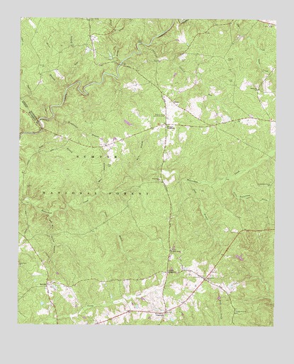
Red Hill, SC USGS Topographic Map
Click on map above to begin viewing in our Map Viewer.

This topographic map contains these locations and features:
Feature Name Type Latitude Longitude GNIS ID View Map
AntiochPopulated PlaceN33.7690°W82.0340°1228969View Map
Antioch ChurchChurchN33.7690°W82.0326°1229353View Map
Antioch Church (historical)ChurchN33.7796°W82.0493°1253352View Map
Antioch School (historical)SchoolN33.7696°W82.0337°1228970View Map
Bailey BranchStreamN33.8696°W82.0787°1229372View Map
Barrs ChapelChurchN33.7801°W82.0501°1228120View Map
Berea ChurchChurchN33.8724°W82.0035°1246748View Map
Broadwater BranchStreamN33.8346°W82.1082°1229458View Map
Brunson CrossroadsPopulated PlaceN33.8321°W82.0535°1247031View Map
Brunson School (historical)SchoolN33.8360°W82.0540°1228971View Map
Brunson-Cleora Community CenterLocaleN33.8360°W82.0537°1229467View Map
Camp BranchStreamN33.8004°W82.0907°1229505View Map
Cartledge School (historical)SchoolN33.8710°W82.0226°1228965View Map
Cedar Grove ChurchChurchN33.7557°W82.0182°1229534View Map
Chap BranchStreamN33.8087°W82.0423°1229541View Map
China Grove ChurchChurchN33.8096°W82.0562°1229553View Map
China Grove School (historical)SchoolN33.8101°W82.0562°1228973View Map
China Grove School (historical)SchoolN33.7979°W82.0504°1228974View Map
CleoraPopulated PlaceN33.8415°W82.0498°1247315View Map
Cochran CemeteryCemeteryN33.8557°W82.1129°1229570View Map
Cockran Church (historical)ChurchN33.8279°W82.1065°1228977View Map
Cold Springs School (historical)SchoolN33.7637°W82.1243°1228982View Map
Collier School (historical)SchoolN33.8660°W82.0215°1228966View Map
Corley CemeteryCemeteryN33.8501°W82.0209°1229594View Map
Crooked RunStreamN33.8649°W82.0607°1229606View Map
Cyper CreekStreamN33.8346°W82.1126°1229613View Map
Dunn CreekStreamN33.8626°W82.0082°1229665View Map
Edgefield DivisionCivilN33.7871°W82.0094°1938255View Map
Gilgal BridgeBridgeN33.8651°W82.0654°1245738View Map
Griffis CemeteryCemeteryN33.8587°W82.0459°1229756View Map
Hammond Grove School (historical)SchoolN33.8310°W82.0373°1228968View Map
Hollingsworth - Walker CemeteryCemeteryN33.8079°W82.0021°1229806View Map
Holmes CemeteryCemeteryN33.8062°W82.1209°1229808View Map
Horse BranchStreamN33.8462°W82.1018°1246065View Map
Johnson CrossroadsPopulated PlaceN33.7718°W82.0521°1246184View Map
Liberty Spring School (historical)SchoolN33.8743°W82.0918°1228975View Map
Little Beaverdam CreekStreamN33.8104°W82.0218°1229911View Map
Mathis Pond Dam D-1692DamN33.8318°W82.0698°1238878View Map
Moores ChurchChurchN33.8468°W82.0098°1230034View Map
Moores School (historical)SchoolN33.8462°W82.0096°1228967View Map
Morgan BridgeBridgeN33.8565°W82.0760°1230038View Map
Moss BranchStreamN33.8049°W82.0851°1230043View Map
Moss CemeteryCemeteryN33.8151°W82.0818°1230044View Map
Moultries Mill (historical)LocaleN33.8293°W82.1137°1228976View Map
Oak Grove School (historical)SchoolN33.7890°W82.0876°1228979View Map
Pike BranchStreamN33.8462°W82.1021°1230161View Map
Pressley CemeteryCemeteryN33.8587°W82.0234°1230198View Map
Red HillLocaleN33.7665°W82.1107°1250305View Map
Red Hill Baptist ChurchChurchN33.7676°W82.1082°1228981View Map
Red Hill School (historical)SchoolN33.7668°W82.1071°1228980View Map
Red Hill Spring BranchStreamN33.7940°W82.1096°1230223View Map
Robinson School (historical)SchoolN33.8335°W82.0540°1228972View Map
Rocky CreekStreamN33.8576°W82.0746°1230250View Map
Shady Grove ChurchChurchN33.7740°W82.1243°1230318View Map
Wash School (historical)SchoolN33.8210°W82.1079°1228978View Map
West Side Community CenterLocaleN33.7696°W82.0340°1230479View Map
West Store CrossroadsPopulated PlaceN33.7560°W82.0521°1251392View Map
Westside Volunteer Fire DepartmentBuildingN33.7553°W82.0531°2578511View Map
White BranchStreamN33.8132°W82.0682°1230484View Map

Note: Coordinates in the location and feature list above are referenced to NAD83 datum.


Copyright (C) 2008-2025 Ryan Niemi / Sunset Dynamics ... All Rights Reserved