TopoQuest Logo
Do you find TopoQuest useful?
Help keep TopoQuest running and adding new maps/features by donating!
Bitcoin:  19c7KJd3qBynnjoSw5npx9KScwjBe4ifkT
Litecoin:  LXs6TkuXGGXo1vDsWCkWVdjQX94eUKd6ui
Home View Maps Find Maps Find Places Resources & Links


San Antonio Mountain, New Mexico Topographic Map

USGS Map Title: San Antonio Mountain, NM
USGS Map MRC: 36106G1
DRG (GeoTIFF) Download: o36106g1.tif


Neighboring USGS Topographic Map Quads:


  Bighorn Peak, NM  
36106H2
 

  Los Pinos, NM  
36106H1
 

  Pinabetoso Peaks, NM  
36105H8
 

  Broke Off Mountain, NM  
36106G2
 

  San Antonio Mountain, NM  
36106G1
 

  La Segita Peaks, NM  
36105G8
 

  Burned Mountain, NM  
36106F2
 

  Mule Canyon, NM  
36106F1
 

  Tres Piedras, NM  
36105F8


Map MRC Location:

N37°
W107°
N37°
W106°
H8 H7 H6 H5 H4 H3 H2 H1
G8 G7 G6 G5 G4 G3 G2 G1
F8 F7 F6 F5 F4 F3 F2 F1
E8 E7 E6 E5 E4 E3 E2 E1
D8 D7 D6 D5 D4 D3 D2 D1
C8 C7 C6 C5 C4 C3 C2 C1
B8 B7 B6 B5 B4 B3 B2 B1
A8 A7 A6 A5 A4 A3 A2 A1
N36°
W107°
N36°
W106°

San Antonio Mountain, NM USGS 1:24K Topographic Map Preview:
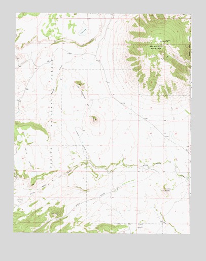
San Antonio Mountain, NM USGS Topographic Map
Click on map above to begin viewing in our Map Viewer.

This topographic map contains these locations and features:
Feature Name Type Latitude Longitude GNIS ID View Map
Aquaje TankReservoirN36.8174°W106.0975°913910View Map
Bean Patch TankReservoirN36.8304°W106.1234°913911View Map
Bean Patch Tank Number OneReservoirN36.8314°W106.1233°913912View Map
Cisneros ParkAreaN36.7661°W106.1206°905176View Map
Corner Tank Number TwoReservoirN36.7732°W106.0774°913913View Map
Felipe TankReservoirN36.8383°W106.1146°913907View Map
Game Department TankReservoirN36.8650°W106.0461°913922View Map
Lamy CanyonValleyN36.7795°W106.0434°907838View Map
Lamy PeakSummitN36.7608°W106.0956°907839View Map
Los Cerritos De La CruzSummitN36.8145°W106.0675°908203View Map
Los Cerritos De La CruzMineN36.8181°W106.0656°916770View Map
Lower San Antone TankReservoirN36.8514°W106.0147°913923View Map
Lucero LakesLakeN36.7834°W106.1110°908305View Map
Lucero TankReservoirN36.7994°W106.0960°913917View Map
Malette CanyonValleyN36.7897°W106.0703°908375View Map
Meadow TankReservoirN36.7573°W106.0842°913924View Map
Montoya CanyonValleyN36.8503°W106.0689°908862View Map
North CisnerosReservoirN36.7688°W106.1047°913916View Map
Pole CorralLocaleN36.8514°W106.0981°913909View Map
Red HillSummitN36.7742°W106.0178°933089View Map
Salin TankReservoirN36.8074°W106.0931°913918View Map
San Antonio MountainSummitN36.8597°W106.0189°928799View Map
San Antonio TankReservoirN36.8561°W106.0225°2678349View Map
South CisnerosReservoirN36.7625°W106.1021°913915View Map
Stanley TankReservoirN36.7582°W106.1177°913914View Map
Stewart CorralLocaleN36.8525°W106.1136°913908View Map
T-Bone RanchLocaleN36.8728°W106.0653°913921View Map
Ursulo LakeLakeN36.8646°W106.0769°912010View Map

Note: Coordinates in the location and feature list above are referenced to NAD83 datum.


Copyright (C) 2008-2025 Ryan Niemi / Sunset Dynamics ... All Rights Reserved