TopoQuest Logo
Do you find TopoQuest useful?
Help keep TopoQuest running and adding new maps/features by donating!
Bitcoin:  19c7KJd3qBynnjoSw5npx9KScwjBe4ifkT
Litecoin:  LXs6TkuXGGXo1vDsWCkWVdjQX94eUKd6ui
Home View Maps Find Maps Find Places Resources & Links


Broke Off Mountain, New Mexico Topographic Map

USGS Map Title: Broke Off Mountain, NM
USGS Map MRC: 36106G2
DRG (GeoTIFF) Download: o36106g2.tif


Neighboring USGS Topographic Map Quads:


  Toltec Mesa, NM  
36106H3
 

  Bighorn Peak, NM  
36106H2
 

  Los Pinos, NM  
36106H1
 

  Lagunitas Creek, NM  
36106G3
 

  Broke Off Mountain, NM  
36106G2
 

  San Antonio Mountain, NM  
36106G1
 

  East Gavilan Canyon, NM  
36106F3
 

  Burned Mountain, NM  
36106F2
 

  Mule Canyon, NM  
36106F1


Map MRC Location:

N37°
W107°
N37°
W106°
H8 H7 H6 H5 H4 H3 H2 H1
G8 G7 G6 G5 G4 G3 G2 G1
F8 F7 F6 F5 F4 F3 F2 F1
E8 E7 E6 E5 E4 E3 E2 E1
D8 D7 D6 D5 D4 D3 D2 D1
C8 C7 C6 C5 C4 C3 C2 C1
B8 B7 B6 B5 B4 B3 B2 B1
A8 A7 A6 A5 A4 A3 A2 A1
N36°
W107°
N36°
W106°

Broke Off Mountain, NM USGS 1:24K Topographic Map Preview:
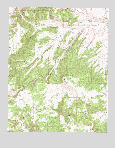
Broke Off Mountain, NM USGS Topographic Map
Click on map above to begin viewing in our Map Viewer.

This topographic map contains these locations and features:
Feature Name Type Latitude Longitude GNIS ID View Map
Alire Tank Number 1ReservoirN36.8733°W106.1886°2678354View Map
Beehive SpringSpringN36.7507°W106.1417°903719View Map
Bernardo TankReservoirN36.7696°W106.1917°913789View Map
Bernardo TankReservoirN36.8333°W106.1320°913800View Map
Broke Off MountainSummitN36.8042°W106.1789°904088View Map
Broke Off TankReservoirN36.7855°W106.1427°913788View Map
Caņada Tio GrandeStreamN36.8603°W106.1486°901463View Map
Cisneros Park SpringSpringN36.7592°W106.1345°913787View Map
Cisneros SpringSpringN36.7699°W106.1506°905177View Map
Dry CanyonLocaleN36.8442°W106.1561°913796View Map
Dry CanyonValleyN36.8567°W106.1495°905871View Map
Dry Canyon Tank Number TwoReservoirN36.8303°W106.1714°2678356View Map
Game Department TankReservoirN36.8057°W106.1579°913798View Map
Jara CanyonValleyN36.8028°W106.1647°2678348View Map
Julian Draw TankReservoirN36.8644°W106.1994°2678353View Map
La Jara TankReservoirN36.8230°W106.1391°913799View Map
Lagunitas CreekStreamN36.8658°W106.2489°907818View Map
Lower TankReservoirN36.7939°W106.1542°2678357View Map
Moeller TankReservoirN36.8480°W106.2041°913797View Map
Negro TankReservoirN36.7804°W106.2252°913794View Map
Olguin Mesa TankReservoirN36.8393°W106.2356°913764View Map
Olguin Pit TanksReservoirN36.8507°W106.2309°913765View Map
Pit TankReservoirN36.7548°W106.2052°913790View Map
Placita CanyonValleyN36.8578°W106.1309°909749View Map
Placito Canyon TankReservoirN36.8399°W106.1489°913795View Map
Porcupine TankReservoirN36.8381°W106.1436°2678355View Map
Rim Rock TankReservoirN36.8664°W106.2278°913766View Map
Rincon ApacheValleyN36.7556°W106.2286°910187View Map
Rincon NegroBasinN36.7695°W106.2175°910202View Map
Rio NutritasStreamN36.8522°W106.1747°910250View Map
San Antonio (historical)Populated PlaceN36.8614°W106.1495°901679View Map
San Antonio CabinLocaleN36.8614°W106.1495°910593View Map
Sandoval TankReservoirN36.7975°W106.1661°2678358View Map
Spring Number OneSpringN36.8342°W106.2497°913763View Map
Stewart MeadowsFlatN36.8550°W106.1253°913099View Map
Tanques CanyValleyN36.8197°W106.2211°913090View Map
Valle GrandeBasinN36.7911°W106.1961°912039View Map
Valle TankReservoirN36.7778°W106.1986°913791View Map
Warm SpringSpringN36.8344°W106.2154°913762View Map
West Boundary TankReservoirN36.7855°W106.1830°913792View Map
West Broke Off TankReservoirN36.7803°W106.1710°2678352View Map

Note: Coordinates in the location and feature list above are referenced to NAD83 datum.


Copyright (C) 2008-2025 Ryan Niemi / Sunset Dynamics ... All Rights Reserved