TopoQuest Logo
Do you find TopoQuest useful?
Help keep TopoQuest running and adding new maps/features by donating!
Bitcoin:  19c7KJd3qBynnjoSw5npx9KScwjBe4ifkT
Litecoin:  LXs6TkuXGGXo1vDsWCkWVdjQX94eUKd6ui
Home View Maps Find Maps Find Places Resources & Links


Sinamox, Oregon Topographic Map

USGS Map Title: Sinamox, OR
USGS Map MRC: 45120C8
DRG (GeoTIFF) Download: o45120c8.tif


Neighboring USGS Topographic Map Quads:


  Dufur East, OR  
45121D1
 

  Summit Ridge, OR  
45120D8
 

  Erskine, OR  
45120D7
 

  Sherars Bridge, OR  
45121C1
 

  Sinamox, OR  
45120C8
 

  Grass Valley, OR  
45120C7
 

  Maupin, OR  
45121B1
 

  Dead Dog Canyon, OR  
45120B8
 

  Bronx Canyon, OR  
45120B7


Map MRC Location:

N46°
W121°
N46°
W120°
H8 H7 H6 H5 H4 H3 H2 H1
G8 G7 G6 G5 G4 G3 G2 G1
F8 F7 F6 F5 F4 F3 F2 F1
E8 E7 E6 E5 E4 E3 E2 E1
D8 D7 D6 D5 D4 D3 D2 D1
C8 C7 C6 C5 C4 C3 C2 C1
B8 B7 B6 B5 B4 B3 B2 B1
A8 A7 A6 A5 A4 A3 A2 A1
N45°
W121°
N45°
W120°

Sinamox, OR USGS 1:24K Topographic Map Preview:
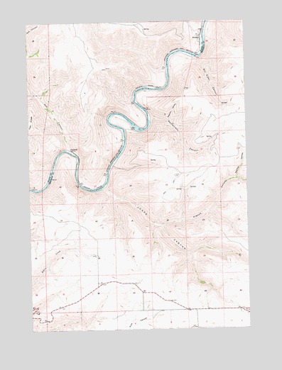
Sinamox, OR USGS Topographic Map
Click on map above to begin viewing in our Map Viewer.

This topographic map contains these locations and features:
Feature Name Type Latitude Longitude GNIS ID View Map
Beavertail Campground Boat RampLocaleN45.3365°W120.9479°2700114View Map
Beavertail Recreation SiteParkN45.3368°W120.9487°1161817View Map
Box Elder CanyonValleyN45.3598°W120.9048°1118012View Map
Buckley (historical)LocaleN45.2579°W120.9067°1130345View Map
Butlers CornerLocaleN45.2651°W120.9373°1638474View Map
Cedar IslandIslandN45.3315°W120.9406°1118755View Map
Ferry CanyonValleyN45.3748°W120.8989°1120686View Map
French CanyonValleyN45.2921°W120.9253°1120981View Map
Gert CanyonValleyN45.3168°W120.9509°1129589View Map
Jones CanyonValleyN45.3071°W120.9589°1122503View Map
Oak CanyonValleyN45.3237°W120.9784°1124897View Map
OakbrookLocaleN45.3226°W120.9773°1124921View Map
Perrault CanyonValleyN45.3112°W120.8820°1125307View Map
Peterson CanyonValleyN45.3346°W120.9220°1125319View Map
Rattlesnake CanyonValleyN45.3354°W120.9320°1125235View Map
Sherar Grade (historical)LocaleN45.2693°W120.9628°1158656View Map
SinamoxLocaleN45.3676°W120.9020°1126998View Map
Sinamox Post Office (historical)Post OfficeN45.3676°W120.9020°1165951View Map
Stanton CanyonValleyN45.3096°W120.8767°1160545View Map
Station CanyonValleyN45.3098°W120.8759°1127550View Map
Tunnel (historical)LocaleN45.3318°W120.9451°1167834View Map

Note: Coordinates in the location and feature list above are referenced to NAD83 datum.


Copyright (C) 2008-2025 Ryan Niemi / Sunset Dynamics ... All Rights Reserved