TopoQuest Logo
Do you find TopoQuest useful?
Help keep TopoQuest running and adding new maps/features by donating!
Bitcoin:  19c7KJd3qBynnjoSw5npx9KScwjBe4ifkT
Litecoin:  LXs6TkuXGGXo1vDsWCkWVdjQX94eUKd6ui
Home View Maps Find Maps Find Places Resources & Links


Soberanes Point, California Topographic Map

USGS Map Title: Soberanes Point, CA
USGS Map MRC: 36121D8
DRG (GeoTIFF) Download: o36121d8.tif


Neighboring USGS Topographic Map Quads:


  Monterey, CA  
36121E8
 

  Seaside, CA  
36121E7


  Soberanes Point, CA  
36121D8
 

  Mount Carmel, CA  
36121D7


  Point Sur, CA  
36121C8
 

  Big Sur, CA  
36121C7


Map MRC Location:

N37°
W122°
N37°
W121°
H8 H7 H6 H5 H4 H3 H2 H1
G8 G7 G6 G5 G4 G3 G2 G1
F8 F7 F6 F5 F4 F3 F2 F1
E8 E7 E6 E5 E4 E3 E2 E1
D8 D7 D6 D5 D4 D3 D2 D1
C8 C7 C6 C5 C4 C3 C2 C1
B8 B7 B6 B5 B4 B3 B2 B1
A8 A7 A6 A5 A4 A3 A2 A1
N36°
W122°
N36°
W121°

Soberanes Point, CA USGS 1:24K Topographic Map Preview:
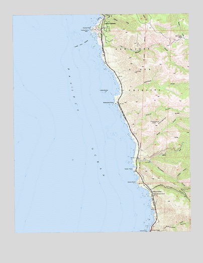
Soberanes Point, CA USGS Topographic Map
Click on map above to begin viewing in our Map Viewer.

This topographic map contains these locations and features:
Feature Name Type Latitude Longitude GNIS ID View Map
Cushing MountainSummitN36.3897°W121.8872°253321View Map
Doud CreekStreamN36.4219°W121.9147°241584View Map
Garrapata CreekStreamN36.4177°W121.9161°242632View Map
Garrapata State ParkParkN36.4605°W121.9141°1703250View Map
Granite CanyonValleyN36.4358°W121.9197°242908View Map
Joshua CreekStreamN36.4155°W121.9052°244143View Map
Kasler PointCapeN36.4111°W121.9169°244199View Map
Las Piedras CanyonValleyN36.3797°W121.9025°244627View Map
Lobos RocksIslandN36.4555°W121.9372°244993View Map
Malpaso CreekStreamN36.4811°W121.9380°245412View Map
Notleys LandingPopulated PlaceN36.3983°W121.9036°1661124View Map
Palo Colorado CanyonValleyN36.3977°W121.9058°247164View Map
Palo Colorado SchoolSchoolN36.3966°W121.9025°247165View Map
Palo Corona RanchLocaleN36.4858°W121.8802°247167View Map
Portuguese RidgeRidgeN36.4427°W121.8891°247714View Map
Puerta del DiabloSummitN36.4375°W121.8994°254177View Map
Rocky CreekStreamN36.3797°W121.9025°248306View Map
Rocky PointCapeN36.4030°W121.9144°248318View Map
Rocky Ridge TrailTrailN36.4669°W121.9141°1873452View Map
San Jose Y Sur ChiquitoCivilN36.4661°W121.9080°248878View Map
Soberanes Canyon TrailTrailN36.4477°W121.9061°1873459View Map
Soberanes CreekStreamN36.4564°W121.9252°249633View Map
Soberanes PointCapeN36.4483°W121.9288°249634View Map
Whale PeakSummitN36.4519°W121.9266°1873474View Map
Wildcat CanyonValleyN36.4041°W121.8855°251549View Map
Wildcat CreekStreamN36.4980°W121.9363°251550View Map
Yankee PointCapeN36.4922°W121.9450°251839View Map
Yankee Point BreakerBarN36.4833°W121.9508°251840View Map
Yankee Point RockIslandN36.4905°W121.9475°251841View Map

Note: Coordinates in the location and feature list above are referenced to NAD83 datum.


Copyright (C) 2008-2024 Ryan Niemi / Sunset Dynamics ... All Rights Reserved