TopoQuest Logo
Do you find TopoQuest useful?
Help keep TopoQuest running and adding new maps/features by donating!
Bitcoin:  19c7KJd3qBynnjoSw5npx9KScwjBe4ifkT
Litecoin:  LXs6TkuXGGXo1vDsWCkWVdjQX94eUKd6ui
Home View Maps Find Maps Find Places Resources & Links


Cape Henlopen, Delaware Topographic Map

USGS Map Title: Cape Henlopen, DE
USGS Map MRC: 38075G1
DRG (GeoTIFF) Download: o38075g1.tif


Neighboring USGS Topographic Map Quads:


  Cape May, NJ  
38074H8
 

  Lewes, DE  
38075G2
 

  Cape Henlopen, DE  
38075G1


  Fairmount, DE  
38075F2
 

  Rehoboth Beach, DE  
38075F1


Map MRC Location:

N39°
W76°
N39°
W75°
H8 H7 H6 H5 H4 H3 H2 H1
G8 G7 G6 G5 G4 G3 G2 G1
F8 F7 F6 F5 F4 F3 F2 F1
E8 E7 E6 E5 E4 E3 E2 E1
D8 D7 D6 D5 D4 D3 D2 D1
C8 C7 C6 C5 C4 C3 C2 C1
B8 B7 B6 B5 B4 B3 B2 B1
A8 A7 A6 A5 A4 A3 A2 A1
N38°
W76°
N38°
W75°

Cape Henlopen, DE USGS 1:24K Topographic Map Preview:
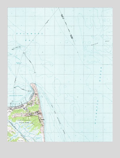
Cape Henlopen, DE USGS Topographic Map
Click on map above to begin viewing in our Map Viewer.

This topographic map contains these locations and features:
Feature Name Type Latitude Longitude GNIS ID View Map
Barcroft Airport (historical)AirportN38.7815°W75.1052°217235View Map
Breakwater HarborBayN38.7923°W75.1146°213704View Map
Cape HenlopenCapeN38.8032°W75.0946°213753View Map
Cape Henlopen State ParkParkN38.7668°W75.0955°216700View Map
Delaware River and Bay Authority Police StationBuildingN38.7820°W75.1188°2379024View Map
Flat SandsFlatN38.7682°W75.0957°213965View Map
Fort Miles (historical)MilitaryN38.7847°W75.0944°2127915View Map
Gills NeckCapeN38.7609°W75.1221°213999View Map
Gordon PondSwampN38.7515°W75.0913°216699View Map
Gordon Pond Wildlife AreaParkN38.7529°W75.0913°217266View Map
Harbor of RefugeBayN38.8237°W75.1077°214055View Map
Hen and Chickens ShoalBarN38.7782°W75.0710°214077View Map
Lewes and Rehoboth CanalCanalN38.7576°W75.1093°214215View Map
Lewes-Cape May FerryLocaleN38.8668°W75.0727°215320View Map
Overfalls ShoalBarN38.8426°W75.0135°874119View Map
Overfalls ShoalBarN38.8418°W75.0191°216525View Map
Sand HillSummitN38.7751°W75.0971°214604View Map
Tower Number EightTowerN38.7796°W75.1196°214917View Map
Tower Number FiveTowerN38.7943°W75.0913°214915View Map
Tower Number FourTowerN38.7762°W75.0924°214913View Map
Tower Number Four ATowerN38.7882°W75.0946°214914View Map
Tower Number SevenTowerN38.7759°W75.1002°214916View Map
University of Delaware College of Marine StudiesSchoolN38.7857°W75.1016°216545View Map
Wolfe GladeStreamN38.7593°W75.1116°216553View Map
Wolfe NeckCapeN38.7501°W75.1085°214874View Map

Note: Coordinates in the location and feature list above are referenced to NAD83 datum.


Copyright (C) 2008-2024 Ryan Niemi / Sunset Dynamics ... All Rights Reserved