TopoQuest Logo
Do you find TopoQuest useful?
Help keep TopoQuest running and adding new maps/features by donating!
Bitcoin:  19c7KJd3qBynnjoSw5npx9KScwjBe4ifkT
Litecoin:  LXs6TkuXGGXo1vDsWCkWVdjQX94eUKd6ui
Home View Maps Find Maps Find Places Resources & Links


Lewes, Delaware Topographic Map

USGS Map Title: Lewes, DE
USGS Map MRC: 38075G2
DRG (GeoTIFF) Download: o38075g2.tif


Neighboring USGS Topographic Map Quads:


  Mispillion River, DE  
38075H3


  Milton, DE  
38075G3
 

  Lewes, DE  
38075G2
 

  Cape Henlopen, DE  
38075G1
 

  Harbeson, DE  
38075F3
 

  Fairmount, DE  
38075F2
 

  Rehoboth Beach, DE  
38075F1


Map MRC Location:

N39°
W76°
N39°
W75°
H8 H7 H6 H5 H4 H3 H2 H1
G8 G7 G6 G5 G4 G3 G2 G1
F8 F7 F6 F5 F4 F3 F2 F1
E8 E7 E6 E5 E4 E3 E2 E1
D8 D7 D6 D5 D4 D3 D2 D1
C8 C7 C6 C5 C4 C3 C2 C1
B8 B7 B6 B5 B4 B3 B2 B1
A8 A7 A6 A5 A4 A3 A2 A1
N38°
W76°
N38°
W75°

Lewes, DE USGS 1:24K Topographic Map Preview:
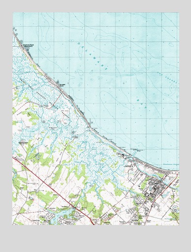
Lewes, DE USGS Topographic Map
Click on map above to begin viewing in our Map Viewer.

This topographic map contains these locations and features:
Feature Name Type Latitude Longitude GNIS ID View Map
Beach Plum IslandIslandN38.8001°W75.1788°216822View Map
Beach Plum Island State ParkParkN38.8001°W75.1788°216823View Map
Beebe Hospital School of NursingSchoolN38.7712°W75.1435°215015View Map
Beebe Medical CenterHospitalN38.7719°W75.1432°1988754View Map
Bethel CemeteryCemeteryN38.7696°W75.1446°216465View Map
Bethel United Methodist ChurchChurchN38.7729°W75.1435°215069View Map
Black Hog GutGutN38.7621°W75.1824°213669View Map
Black Hog LandingPopulated PlaceN38.7740°W75.1905°216037View Map
Blockhouse PondLakeN38.7708°W75.1463°215527View Map
Bookhammers PondLakeN38.7538°W75.1290°213689View Map
Broadkill BeachBeachN38.8190°W75.2005°213712View Map
Broadkill BeachPopulated PlaceN38.8282°W75.2119°213713View Map
Broadkill HundredCivilN38.8334°W75.2413°217204View Map
Broadkill RiverStreamN38.7904°W75.1621°213715View Map
Broadkill SoundBayN38.8176°W75.2024°213716View Map
Burtons ChapelChurchN38.7704°W75.2316°216548View Map
Canary CreekStreamN38.7901°W75.1635°216826View Map
Cape Henlopen Junior High SchoolSchoolN38.7648°W75.1441°216354View Map
Capes Cove Mobile Home ParkPopulated PlaceN38.7643°W75.1691°216637View Map
Carsylian AcresPopulated PlaceN38.7515°W75.2302°216544View Map
City of LewesCivilN38.7798°W75.1457°2390609View Map
Covey CreekPopulated PlaceN38.7565°W75.1580°215524View Map
Covington NeckCapeN38.7912°W75.2313°213835View Map
Cripple CreekPopulated PlaceN38.7671°W75.2396°215510View Map
Crooked CreekStreamN38.8054°W75.2196°213844View Map
Davidson MarshSwampN38.8034°W75.2377°213857View Map
Ditch CreekStreamN38.7921°W75.1860°213889View Map
Donovan DevelopmentPopulated PlaceN38.7637°W75.1374°216560View Map
Doty GladeStreamN38.8051°W75.2232°213896View Map
Dutch AcresPopulated PlaceN38.7507°W75.1794°215520View Map
Eagle Crest-Hudson AirportAirportN38.7736°W75.2306°216562View Map
East Mill RunPopulated PlaceN38.7621°W75.2066°215513View Map
Ebenezer BranchStreamN38.7659°W75.1580°213924View Map
EdgewaterPopulated PlaceN38.7532°W75.2049°215517View Map
First Baptist Church of LewesChurchN38.7613°W75.1454°2555122View Map
Fisher CreekStreamN38.7851°W75.1930°213959View Map
Flatland ReachChannelN38.8062°W75.2038°213966View Map
Friendship ChurchChurchN38.7762°W75.1474°216464View Map
Great MarshSwampN38.7959°W75.1952°214025View Map
Green HillPopulated PlaceN38.7912°W75.1671°216103View Map
Groome United Methodist ChurchChurchN38.7696°W75.1441°215068View Map
Hazzard LandingPopulated PlaceN38.8104°W75.2135°216109View Map
Hells NeckCapeN38.7665°W75.1732°214075View Map
Henlopen Memorial ParkCemeteryN38.7898°W75.2464°216460View Map
HeronwoodPopulated PlaceN38.7604°W75.2230°215512View Map
Highland AcresPopulated PlaceN38.7654°W75.1552°216827View Map
Highland AcresPopulated PlaceN38.7676°W75.1466°215526View Map
Holland CemeteryCemeteryN38.7696°W75.2321°216461View Map
Holland PondLakeN38.7929°W75.2205°214104View Map
HoustonPopulated PlaceN38.7876°W75.2405°216821View Map
LewesPopulated PlaceN38.7746°W75.1393°214214View Map
Lewes BeachPopulated PlaceN38.7851°W75.1480°214216View Map
Lewes City HallBuildingN38.7732°W75.1377°2379019View Map
Lewes City Power PlantLocaleN38.7718°W75.1378°2379018View Map
Lewes Fire Department Station 1 HeadquartersBuildingN38.7724°W75.1407°2610792View Map
Lewes Junior High SchoolSchoolN38.7687°W75.1460°214923View Map
Lewes PitMineN38.7556°W75.1739°2635773View Map
Lewes Police DepartmentBuildingN38.7734°W75.1379°2131097View Map
Lewes Post OfficePost OfficeN38.7757°W75.1391°2379017View Map
Lewes Presbyterian ChurchChurchN38.7726°W75.1391°215066View Map
Lewes Public LibraryBuildingN38.7677°W75.1419°2379014View Map
Lewes Sewage Treatment PlantLocaleN38.7775°W75.1325°2378375View Map
Long ReachChannelN38.8104°W75.2257°214254View Map
Maulls Wharf (historical)LocaleN38.7823°W75.1343°215291View Map
McNichol PlacePopulated PlaceN38.7518°W75.1605°215521View Map
Mill Creek ManorPopulated PlaceN38.7584°W75.1988°215515View Map
Mill Pond AcresPopulated PlaceN38.7573°W75.1982°215516View Map
Millpond AcresPopulated PlaceN38.7646°W75.2038°216819View Map
Murrays CornerPopulated PlaceN38.7521°W75.1502°216162View Map
NassauPopulated PlaceN38.7521°W75.1877°214371View Map
No Mans Friend ReachChannelN38.8071°W75.2196°214389View Map
North Jetty LightLocaleN38.7946°W75.1571°217767View Map
Old Inlet BeachBeachN38.8171°W75.2002°215509View Map
Old Mill CreekStreamN38.8037°W75.1955°214414View Map
OverbrookPopulated PlaceN38.7676°W75.2149°216171View Map
Overbrook ShoresPopulated PlaceN38.7584°W75.2252°215511View Map
Oyster RocksPopulated PlaceN38.8021°W75.2027°216173View Map
Oyster Rocks NeckCapeN38.7926°W75.2135°214423View Map
Petersfield DitchCanalN38.8309°W75.2288°214444View Map
Petersfield IslandIslandN38.8204°W75.2227°214445View Map
PilottownPopulated PlaceN38.7798°W75.1524°216824View Map
Plumb Point (historical)CapeN38.8334°W75.2163°217198View Map
Primehook BeachBeachN38.8443°W75.2319°214494View Map
Primehook BeachPopulated PlaceN38.8557°W75.2427°214495View Map
Primehook CreekStreamN38.8346°W75.2221°214496View Map
Quakers HeightsPopulated PlaceN38.7551°W75.1588°215522View Map
QuakertownPopulated PlaceN38.7554°W75.1594°214506View Map
Red Hill ManorPopulated PlaceN38.7615°W75.2057°215514View Map
Red Mill PondReservoirN38.7503°W75.2136°214527View Map
Red Mill Pond DamDamN38.7601°W75.2035°216820View Map
Richard A Shields Elemantary SchoolSchoolN38.7673°W75.1482°216457View Map
Roach MarshSwampN38.8507°W75.2463°214549View Map
Robertson LandingPopulated PlaceN38.8054°W75.2430°216196View Map
Roosevelt InletGutN38.7929°W75.1580°214559View Map
Saint George CemeteryCemeteryN38.7790°W75.1491°216463View Map
Saint Jude the Apostle ChurchChurchN38.7500°W75.1806°2379006View Map
Saint Peters ChurchChurchN38.7759°W75.1407°215067View Map
Sand Dunes VillagePopulated PlaceN38.7568°W75.1802°215519View Map
Savannah PlacePopulated PlaceN38.7640°W75.1613°216561View Map
Shady SidePopulated PlaceN38.7526°W75.2019°215518View Map
Shaffer PropertyPopulated PlaceN38.7565°W75.1577°215523View Map
Shell Beach PondLakeN38.8355°W75.2497°214634View Map
South Jetty LightLocaleN38.7937°W75.1557°217768View Map
South Street BridgeBridgeN38.7757°W75.1377°216825View Map
Star LandingPopulated PlaceN38.7609°W75.2024°216225View Map
Steamboat LandingPopulated PlaceN38.7987°W75.2421°216514View Map
SwanendaelPopulated PlaceN38.7651°W75.1632°215525View Map
Sweet Briar Mobile Home ParkPopulated PlaceN38.7515°W75.2260°216540View Map
The ShearsBarN38.8334°W75.1330°216539View Map
The ShearsBarN38.8329°W75.1257°214736View Map
University of Delaware College of Marine and Earth Studies Sharp CampusSchoolN38.7855°W75.1608°216462View Map
Wall IslandIslandN38.8162°W75.2116°214802View Map
Wescoats CornerPopulated PlaceN38.7518°W75.1644°214819View Map
Whale BackBarN38.8459°W75.1996°215281View Map
White NeckCapeN38.7976°W75.2338°214838View Map
Whites ChapelChurchN38.7734°W75.2230°214845View Map
Whites Chapel CemeteryCemeteryN38.7734°W75.2225°2378987View Map
Wiltbank LandingPopulated PlaceN38.8087°W75.2402°216253View Map
Zwaanendael MuseumBuildingN38.7734°W75.1395°2379016View Map

Note: Coordinates in the location and feature list above are referenced to NAD83 datum.


Copyright (C) 2008-2024 Ryan Niemi / Sunset Dynamics ... All Rights Reserved