TopoQuest Logo
Do you find TopoQuest useful?
Help keep TopoQuest running and adding new maps/features by donating!
Bitcoin:  19c7KJd3qBynnjoSw5npx9KScwjBe4ifkT
Litecoin:  LXs6TkuXGGXo1vDsWCkWVdjQX94eUKd6ui
Home View Maps Find Maps Find Places Resources & Links


Stewart Mountain, Arizona Topographic Map

USGS Map Title: Stewart Mountain, AZ
USGS Map MRC: 33111E5
DRG (GeoTIFF) Download: o33111e5.tif


Neighboring USGS Topographic Map Quads:


  Fort McDowell, AZ  
33111F6
 

  Adams Mesa, AZ  
33111F5
 

  Mine Mountain, AZ  
33111F4
 

  Granite Reef Dam, AZ  
33111E6
 

  Stewart Mountain, AZ  
33111E5
 

  Mormon Flat Dam, AZ  
33111E4
 

  Buckhorn, AZ  
33111D6
 

  Apache Junction, AZ  
33111D5
 

  Goldfield, AZ  
33111D4


Map MRC Location:

N34°
W112°
N34°
W111°
H8 H7 H6 H5 H4 H3 H2 H1
G8 G7 G6 G5 G4 G3 G2 G1
F8 F7 F6 F5 F4 F3 F2 F1
E8 E7 E6 E5 E4 E3 E2 E1
D8 D7 D6 D5 D4 D3 D2 D1
C8 C7 C6 C5 C4 C3 C2 C1
B8 B7 B6 B5 B4 B3 B2 B1
A8 A7 A6 A5 A4 A3 A2 A1
N33°
W112°
N33°
W111°

Stewart Mountain, AZ USGS 1:24K Topographic Map Preview:
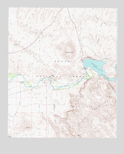
Stewart Mountain, AZ USGS Topographic Map
Click on map above to begin viewing in our Map Viewer.

This topographic map contains these locations and features:
Feature Name Type Latitude Longitude GNIS ID View Map
Beeline TankReservoirN33.6000°W111.5946°26187View Map
Blue PointCliffN33.5600°W111.5718°26518View Map
Blue Point Administrative SiteLocaleN33.5528°W111.6071°26521View Map
Blue Point Picnic AreaParkN33.5556°W111.5757°26520View Map
Blue Point Recreation SiteLocaleN33.5556°W111.5729°26519View Map
Bulldog CanyonValleyN33.5481°W111.5726°26993View Map
Butcher Jones Picnic AreaLocaleN33.5763°W111.5151°2669519View Map
Butcher Jones Recreation SiteParkN33.5764°W111.5137°27074View Map
Dome MountainSummitN33.5028°W111.5446°28529View Map
Flower TankReservoirN33.5873°W111.6174°29072View Map
Goldfield Administrative SiteBuildingN33.5550°W111.6168°41703View Map
Goldfield MountainsSummitN33.5200°W111.5135°29403View Map
Goldfield RanchLocaleN33.5984°W111.6046°41698View Map
Goldfield Ranch AirportAirportN33.5978°W111.6062°2651005View Map
Goldfield Recreation SiteLocaleN33.5542°W111.6210°41704View Map
Jones CanyonValleyN33.5762°W111.5168°30598View Map
Junction Recreation SiteLocaleN33.5448°W111.6121°41702View Map
Lone MountainSummitN33.5094°W111.6040°32530View Map
Lost TankReservoirN33.6184°W111.5987°31310View Map
Saguaro Del Norte Picnic AreaLocaleN33.5764°W111.5329°2669531View Map
Saguaro del Norte Recreation SiteParkN33.5767°W111.5343°33944View Map
Saguaro LakeReservoirN33.5693°W111.5252°33945View Map
Saguaro Lake MarinaLocaleN33.5728°W111.5387°41705View Map
Saguaro Lake Ranch ResortLocaleN33.5592°W111.5362°41699View Map
Salt River Project HousingLocaleN33.5581°W111.5362°41700View Map
Sheep BridgeBridgeN33.5553°W111.5871°34320View Map
Stewart MountainSummitN33.5820°W111.5576°34846View Map
Stewart Mountain DamDamN33.5667°W111.5358°34847View Map
Stewart Mountain Dam HeliportAirportN33.5523°W111.5496°45367View Map
Sunrise ArchArchN33.5481°W111.5389°2629404View Map
Water Users Recreation SiteLocaleN33.5556°W111.5390°41701View Map
Willow Springs CanyonValleyN33.5542°W111.5090°36277View Map

Note: Coordinates in the location and feature list above are referenced to NAD83 datum.


Copyright (C) 2008-2024 Ryan Niemi / Sunset Dynamics ... All Rights Reserved