TopoQuest Logo
Do you find TopoQuest useful?
Help keep TopoQuest running and adding new maps/features by donating!
Bitcoin:  19c7KJd3qBynnjoSw5npx9KScwjBe4ifkT
Litecoin:  LXs6TkuXGGXo1vDsWCkWVdjQX94eUKd6ui
Home View Maps Find Maps Find Places Resources & Links


Mormon Flat Dam, Arizona Topographic Map

USGS Map Title: Mormon Flat Dam, AZ
USGS Map MRC: 33111E4
DRG (GeoTIFF) Download: o33111e4.tif


Neighboring USGS Topographic Map Quads:


  Adams Mesa, AZ  
33111F5
 

  Mine Mountain, AZ  
33111F4
 

  Four Peaks, AZ  
33111F3
 

  Stewart Mountain, AZ  
33111E5
 

  Mormon Flat Dam, AZ  
33111E4
 

  Horse Mesa Dam, AZ  
33111E3
 

  Apache Junction, AZ  
33111D5
 

  Goldfield, AZ  
33111D4
 

  Weavers Needle, AZ  
33111D3


Map MRC Location:

N34°
W112°
N34°
W111°
H8 H7 H6 H5 H4 H3 H2 H1
G8 G7 G6 G5 G4 G3 G2 G1
F8 F7 F6 F5 F4 F3 F2 F1
E8 E7 E6 E5 E4 E3 E2 E1
D8 D7 D6 D5 D4 D3 D2 D1
C8 C7 C6 C5 C4 C3 C2 C1
B8 B7 B6 B5 B4 B3 B2 B1
A8 A7 A6 A5 A4 A3 A2 A1
N33°
W112°
N33°
W111°

Mormon Flat Dam, AZ USGS 1:24K Topographic Map Preview:
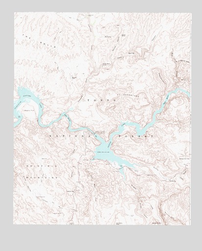
Mormon Flat Dam, AZ USGS Topographic Map
Click on map above to begin viewing in our Map Viewer.

This topographic map contains these locations and features:
Feature Name Type Latitude Longitude GNIS ID View Map
Acacia Picnic AreaLocaleN33.5379°W111.4332°2669517View Map
Acacia Recreation SiteParkN33.5373°W111.4324°36916View Map
Apache GapGapN33.5203°W111.4565°25700View Map
Bagley FlatFlatN33.5673°W111.4882°25887View Map
Bagley Flat Recreation SiteLocaleN33.5695°W111.4899°36927View Map
Bagley TankReservoirN33.5392°W111.4804°25888View Map
Black Canyon (historical)ValleyN33.5334°W111.4507°44983View Map
Blue SpringSpringN33.6112°W111.4362°26533View Map
Blue Tank CanyonValleyN33.5812°W111.3851°26539View Map
Boulder CanyonValleyN33.5153°W111.4112°26642View Map
Boulder Picnic AreaLocaleN33.5318°W111.4256°2669518View Map
Boulder Recreation SiteParkN33.5317°W111.4251°36934View Map
Brownie TankReservoirN33.5867°W111.4599°26794View Map
Cane Spring CanyonValleyN33.5914°W111.4421°27250View Map
Canyon LakeReservoirN33.5413°W111.4325°27276View Map
Canyon Lake MarinaLocaleN33.5359°W111.4210°40895View Map
Cholla TankReservoirN33.5055°W111.4176°27614View Map
Cottonwood CampLocaleN33.6234°W111.4474°27998View Map
Cottonwood CreekStreamN33.5662°W111.4637°28016View Map
Cottonwood TrailheadLocaleN33.6209°W111.4479°40896View Map
El RecortadoSummitN33.5764°W111.4204°28839View Map
First Water CreekStreamN33.5370°W111.4451°29016View Map
Geronimo HeadSummitN33.5037°W111.3857°45631View Map
Hells Hip PocketValleyN33.5950°W111.3843°29871View Map
Hidden Water SpringSpringN33.5941°W111.4378°29955View Map
Ittindi RockCliffN33.5473°W111.4390°45671View Map
La Barge CanyonValleyN33.5264°W111.4212°30825View Map
La Barge CanyonValleyN33.5070°W111.4257°40467View Map
La Barge CreekStreamN33.5264°W111.4215°44812View Map
Laguna Boating SiteLocaleN33.5334°W111.4168°40894View Map
Laguna Recreation Site One Hundred FiftyParkN33.5320°W111.4149°37013View Map
Mesa Ranger DistrictForestN33.6050°W111.4115°2038569View Map
Mesquite CreekStreamN33.5300°W111.3829°31762View Map
Mesquite FlatFlatN33.5387°W111.3771°31764View Map
Mormon Flat (historical)FlatN33.5403°W111.4382°37040View Map
Mormon Flat DamDamN33.5535°W111.4431°32043View Map
Mormon Flat Dam HeliportAirportN33.5534°W111.4454°45364View Map
Palo Verde Boating SiteLocaleN33.5373°W111.4293°40893View Map
Palo Verde Recreation Site 147ParkN33.5348°W111.4299°37053View Map
Peters CanyonValleyN33.5239°W111.3762°32819View Map
Salt River Project HousingLocaleN33.5537°W111.4462°40898View Map
Satchin CliffCliffN33.5492°W111.4354°45677View Map
Secucito SpringSpringN33.6118°W111.4244°34239View Map
Seucito CanyonValleyN33.5956°W111.4299°34268View Map
Sheep MountainSummitN33.5898°W111.3979°34338View Map
Ship RockIslandN33.5634°W111.4971°34380View Map
The Point Boating CampgroundLocaleN33.5569°W111.4112°2670550View Map
The Point Recreation SiteLocaleN33.5570°W111.4112°37097View Map
Tortilla CampgroundLocaleN33.5300°W111.3988°2670347View Map
Tortilla CreekStreamN33.5364°W111.4149°35405View Map
Tortilla FlatPopulated PlaceN33.5264°W111.3899°35406View Map
Tortilla Recreation SiteParkN33.5295°W111.4007°37099View Map
Whirlpool RockSummitN33.6000°W111.4667°2676278View Map
Willow CreekStreamN33.5556°W111.4549°36226View Map
Willow SpringSpringN33.5070°W111.4665°2056830View Map
Willow Springs Basin TankReservoirN33.5163°W111.4843°36276View Map
Willow Springs WellWellN33.5075°W111.4660°36280View Map
Yachin CliffCliffN33.5368°W111.4341°2676279View Map

Note: Coordinates in the location and feature list above are referenced to NAD83 datum.


Copyright (C) 2008-2025 Ryan Niemi / Sunset Dynamics ... All Rights Reserved