TopoQuest Logo
Do you find TopoQuest useful?
Help keep TopoQuest running and adding new maps/features by donating!
Bitcoin:  19c7KJd3qBynnjoSw5npx9KScwjBe4ifkT
Litecoin:  LXs6TkuXGGXo1vDsWCkWVdjQX94eUKd6ui
Home View Maps Find Maps Find Places Resources & Links


Tamarack, Idaho Topographic Map

USGS Map Title: Tamarack, ID
USGS Map MRC: 44116H4
DRG (GeoTIFF) Download: o44116h4.tif


Neighboring USGS Topographic Map Quads:


  Butterfield Gulch, ID  
45116A5
 

  Railroad Saddle, ID  
45116A4
 

  Bally Mountain, ID  
45116A3
 

  Weasel Gulch, ID  
44116H5
 

  Tamarack, ID  
44116H4
 

  New Meadows, ID  
44116H3
 

  Peck Mountain, ID  
44116G5
 

  Fruitvale, ID  
44116G4
 

  Cold Spring Summit, ID  
44116G3


Map MRC Location:

N45°
W117°
N45°
W116°
H8 H7 H6 H5 H4 H3 H2 H1
G8 G7 G6 G5 G4 G3 G2 G1
F8 F7 F6 F5 F4 F3 F2 F1
E8 E7 E6 E5 E4 E3 E2 E1
D8 D7 D6 D5 D4 D3 D2 D1
C8 C7 C6 C5 C4 C3 C2 C1
B8 B7 B6 B5 B4 B3 B2 B1
A8 A7 A6 A5 A4 A3 A2 A1
N44°
W117°
N44°
W116°

Tamarack, ID USGS 1:24K Topographic Map Preview:
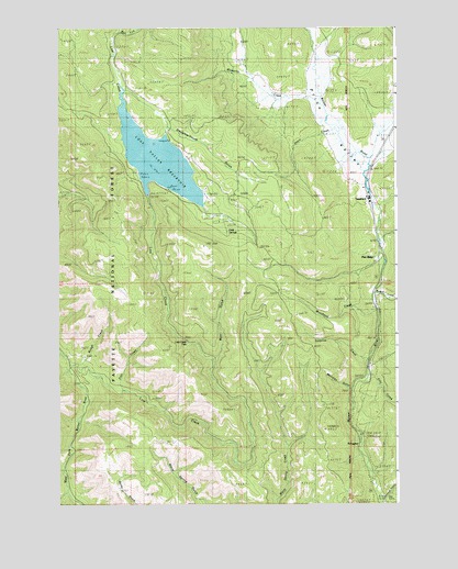
Tamarack, ID USGS Topographic Map
Click on map above to begin viewing in our Map Viewer.

This topographic map contains these locations and features:
Feature Name Type Latitude Longitude GNIS ID View Map
Adams CountyCivilN44.8896°W116.4539°395067View Map
Bear GulchValleyN44.9135°W116.4426°377148View Map
Beaver CreekStreamN44.9313°W116.3835°377248View Map
Cold SpringSpringN44.9466°W116.4382°395239View Map
Cold Springs CampgroundLocaleN44.9493°W116.4410°394473View Map
East Fork Lost CreekStreamN44.9999°W116.4760°381127View Map
EvergreenPopulated PlaceN44.8902°W116.3901°381512View Map
Evergreen CampgroundLocaleN44.8932°W116.3890°394474View Map
Filly CreekStreamN44.9085°W116.3865°395379View Map
Finn CreekStreamN44.9052°W116.4765°381693View Map
IXL MineMineN44.9982°W116.4249°394477View Map
Lost CreekStreamN44.9104°W116.4960°386146View Map
Lost Creek FallsFallsN44.9178°W116.4531°395653View Map
Lost Valley DamDamN44.9563°W116.4672°398856View Map
Lost Valley ReservoirReservoirN44.9654°W116.4634°397875View Map
Meridian GulchValleyN44.9052°W116.3932°386746View Map
Mosquito CreekStreamN44.9807°W116.4035°387257View Map
Pine RidgePopulated PlaceN44.9388°W116.3826°397993View Map
Price ValleyValleyN44.9643°W116.3857°388872View Map
Railroad CreekStreamN44.8752°W116.3815°389029View Map
Rough CreekStreamN44.9124°W116.4940°389635View Map
Skern CreekStreamN44.9735°W116.3990°390512View Map
Slaughter Gulch CampgroundLocaleN44.9702°W116.4587°394472View Map
Slaughterhouse GulchValleyN44.9741°W116.4596°395955View Map
Surprise CreekStreamN44.9129°W116.3862°391679View Map
TamarackPopulated PlaceN44.9552°W116.3857°391826View Map
Warm Spring GulchValleyN44.8752°W116.4463°392869View Map
WoodlandPopulated PlaceN44.9302°W116.3829°398381View Map
Woodland CreekStreamN44.9260°W116.3832°393671View Map

Note: Coordinates in the location and feature list above are referenced to NAD83 datum.


Copyright (C) 2008-2025 Ryan Niemi / Sunset Dynamics ... All Rights Reserved