TopoQuest Logo
Do you find TopoQuest useful?
Help keep TopoQuest running and adding new maps/features by donating!
Bitcoin:  19c7KJd3qBynnjoSw5npx9KScwjBe4ifkT
Litecoin:  LXs6TkuXGGXo1vDsWCkWVdjQX94eUKd6ui
Home View Maps Find Maps Find Places Resources & Links


West Union, Illinois Topographic Map

USGS Map Title: West Union, IL
USGS Map MRC: 39087B6
DRG (GeoTIFF) Download: o39087b6.tif


Neighboring USGS Topographic Map Quads:


  Clark Center, IL  
39087C7
 

  Snyder, IL  
39087C6
 

  Hutton, IN  
39087C5
 

  Annapolis, IL  
39087B7
 

  West Union, IL  
39087B6
 

  Fairbanks, IN  
39087B5
 

  Porterville, IL  
39087A7
 

  Hutsonville, IL  
39087A6
 

  Merom, IN  
39087A5


Map MRC Location:

N40°
W88°
N40°
W87°
H8 H7 H6 H5 H4 H3 H2 H1
G8 G7 G6 G5 G4 G3 G2 G1
F8 F7 F6 F5 F4 F3 F2 F1
E8 E7 E6 E5 E4 E3 E2 E1
D8 D7 D6 D5 D4 D3 D2 D1
C8 C7 C6 C5 C4 C3 C2 C1
B8 B7 B6 B5 B4 B3 B2 B1
A8 A7 A6 A5 A4 A3 A2 A1
N39°
W88°
N39°
W87°

West Union, IL USGS 1:24K Topographic Map Preview:
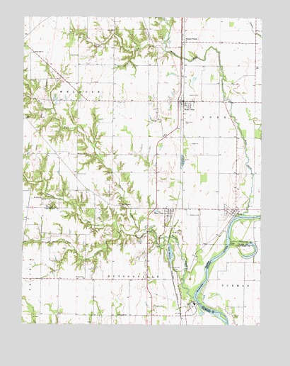
West Union, IL USGS Topographic Map
Click on map above to begin viewing in our Map Viewer.

This topographic map contains these locations and features:
Feature Name Type Latitude Longitude GNIS ID View Map
Bailff CemeteryCemeteryN39.1739°W87.6992°1922864View Map
Bradbury CemeteryCemeteryN39.1698°W87.6634°404771View Map
Clark County Ambulance ServiceBuildingN39.2161°W87.6663°2673945View Map
Crow School (historical)SchoolN39.1948°W87.7028°1736440View Map
Draper CemeteryCemeteryN39.1481°W87.6714°407381View Map
Faith ChurchChurchN39.2017°W87.6767°408242View Map
Guyer CemeteryCemeteryN39.1475°W87.7114°409584View Map
Harrison CemeteryCemeteryN39.2084°W87.6797°409857View Map
Hogue CemeteryCemeteryN39.1986°W87.6622°410366View Map
Hutsonville ChurchChurchN39.1287°W87.6997°410736View Map
Hutsonville Power StationBuildingN39.1339°W87.6600°2419849View Map
Hutsonville Township Fire Protection District Station 2 West YorkBuildingN39.1716°W87.6720°2682280View Map
Island CemeteryCemeteryN39.1286°W87.6384°436845View Map
Lake WaltonLakeN39.1542°W87.6725°420499View Map
Liberty CemeteryCemeteryN39.2345°W87.7220°411990View Map
Liberty School (historical)SchoolN39.2231°W87.7261°1736449View Map
Lindley CemeteryCemeteryN39.1603°W87.6786°412234View Map
Little CreekStreamN39.2392°W87.6761°412311View Map
Mill CreekStreamN39.1698°W87.6345°413547View Map
Mount Olive Baptist ChurchChurchN39.1764°W87.7406°414018View Map
Mount Olive CemeteryCemeteryN39.1742°W87.7397°1922959View Map
Musgrave CemeteryCemeteryN39.1323°W87.6809°414262View Map
New Providence ChurchChurchN39.1737°W87.6986°414455View Map
North Fork Raccoon CreekStreamN39.1606°W87.6900°414603View Map
Ohio CemeteryCemeteryN39.2442°W87.7022°1922964View Map
Ohio ChapelChurchN39.2445°W87.7031°414972View Map
Old Channel LakeLakeN39.1539°W87.6289°447922View Map
Pleasant Grove ChurchChurchN39.1439°W87.7170°415792View Map
Plymouth CemeteryCemeteryN39.1861°W87.7222°415964View Map
Potters Hall ChurchChurchN39.2356°W87.7450°416083View Map
Raccoon CreekStreamN39.1362°W87.6597°416334View Map
Shawler CemeteryCemeteryN39.2184°W87.6589°418313View Map
South Fork Raccoon CreekStreamN39.1623°W87.6995°418770View Map
Township of MelroseCivilN39.2196°W87.7344°429352View Map
Township of YorkCivilN39.2167°W87.6355°429969View Map
Walnut PrairiePopulated PlaceN39.2400°W87.6661°420478View Map
West UnionPopulated PlaceN39.2159°W87.6661°420931View Map
West Union Census Designated PlaceCensusN39.2150°W87.6657°2628562View Map
West Union Community Fire Protection DistrictBuildingN39.2162°W87.6670°2681740View Map
West Union ParkParkN39.2073°W87.6659°420934View Map
West Union Post OfficePost OfficeN39.2162°W87.6680°1785526View Map
West YorkPopulated PlaceN39.1712°W87.6736°420946View Map
West York Census Designated PlaceCensusN39.1688°W87.6730°2583444View Map
YorkPopulated PlaceN39.1714°W87.6392°421580View Map
York CemeteryCemeteryN39.1731°W87.6472°1922991View Map
York CutoffChannelN39.1589°W87.6420°421582View Map
York Ferry (historical)CrossingN39.1684°W87.6378°1968142View Map

Note: Coordinates in the location and feature list above are referenced to NAD83 datum.


Copyright (C) 2008-2024 Ryan Niemi / Sunset Dynamics ... All Rights Reserved