TopoQuest Logo
Do you find TopoQuest useful?
Help keep TopoQuest running and adding new maps/features by donating!
Bitcoin:  19c7KJd3qBynnjoSw5npx9KScwjBe4ifkT
Litecoin:  LXs6TkuXGGXo1vDsWCkWVdjQX94eUKd6ui
Home View Maps Find Maps Find Places Resources & Links


Wildwood, Michigan Topographic Map

USGS Map Title: Wildwood, MI
USGS Map MRC: 45084C6
DRG (GeoTIFF) Download: o45084c6.tif


Neighboring USGS Topographic Map Quads:


  Burt Lake, MI  
45084D6
 

  Indian River, MI  
45084D5


  Wildwood, MI  
45084C6
 

  Wolverine, MI  
45084C5
 

  Thumb Lake, MI  
45084B7
 

  Vanderbilt, MI  
45084B6
 

  Green Timbers, MI  
45084B5


Map MRC Location:

N46°
W85°
N46°
W84°
H8 H7 H6 H5 H4 H3 H2 H1
G8 G7 G6 G5 G4 G3 G2 G1
F8 F7 F6 F5 F4 F3 F2 F1
E8 E7 E6 E5 E4 E3 E2 E1
D8 D7 D6 D5 D4 D3 D2 D1
C8 C7 C6 C5 C4 C3 C2 C1
B8 B7 B6 B5 B4 B3 B2 B1
A8 A7 A6 A5 A4 A3 A2 A1
N45°
W85°
N45°
W84°

Wildwood, MI USGS 1:24K Topographic Map Preview:
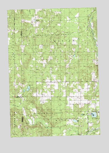
Wildwood, MI USGS Topographic Map
Click on map above to begin viewing in our Map Viewer.

This topographic map contains these locations and features:
Feature Name Type Latitude Longitude GNIS ID View Map
Allen CreekStreamN45.2539°W84.6378°619967View Map
Barhite LakeLakeN45.2644°W84.6594°620598View Map
Fulmer LakeLakeN45.2702°W84.6498°626561View Map
Hope Lutheran ChurchChurchN45.3722°W84.6297°2369387View Map
Indian River Catholic Shrine CemeteryCemeteryN45.3678°W84.6364°2369427View Map
Joy Fellowship Assembly of God ChurchChurchN45.3383°W84.6300°2369385View Map
Kingdom Hall of Jehovah's WitnessesChurchN45.3686°W84.6342°2369386View Map
Marl CreekStreamN45.2511°W84.6561°631585View Map
Rondo CemeteryCemeteryN45.3322°W84.6286°2369440View Map
Silver LakeLakeN45.2698°W84.6330°637950View Map
Silver Lake CemeteryCemeteryN45.2722°W84.6272°637960View Map
Township of MentorCivilN45.3319°W84.6703°1626725View Map
Weber LakeLakeN45.2974°W84.7236°1615943View Map
Weber Lake State Forest CampgroundLocaleN45.2978°W84.7211°2369336View Map
WildwoodPopulated PlaceN45.3631°W84.7109°1617946View Map
Wildwood Post Office (historical)Post OfficeN45.3631°W84.7108°2369391View Map

Note: Coordinates in the location and feature list above are referenced to NAD83 datum.


Copyright (C) 2008-2025 Ryan Niemi / Sunset Dynamics ... All Rights Reserved