TopoQuest Logo
Do you find TopoQuest useful?
Help keep TopoQuest running and adding new maps/features by donating!
Bitcoin:  19c7KJd3qBynnjoSw5npx9KScwjBe4ifkT
Litecoin:  LXs6TkuXGGXo1vDsWCkWVdjQX94eUKd6ui
Home View Maps Find Maps Find Places Resources & Links


Woodbury, Georgia Topographic Map

USGS Map Title: Woodbury, GA
USGS Map MRC: 32084H5
DRG (GeoTIFF) Download: o32084h5.tif


Neighboring USGS Topographic Map Quads:


  Greenville, GA  
33084A6
 

  Gay, GA  
33084A5
 

  Concord, GA  
33084A4
 

  Warm Springs, GA  
32084H6
 

  Woodbury, GA  
32084H5
 

  Sunset Village, GA  
32084H4
 

  Shiloh, GA  
32084G6
 

  Manchester, GA  
32084G5
 

  Roland, GA  
32084G4


Map MRC Location:

N33°
W85°
N33°
W84°
H8 H7 H6 H5 H4 H3 H2 H1
G8 G7 G6 G5 G4 G3 G2 G1
F8 F7 F6 F5 F4 F3 F2 F1
E8 E7 E6 E5 E4 E3 E2 E1
D8 D7 D6 D5 D4 D3 D2 D1
C8 C7 C6 C5 C4 C3 C2 C1
B8 B7 B6 B5 B4 B3 B2 B1
A8 A7 A6 A5 A4 A3 A2 A1
N32°
W85°
N32°
W84°

Woodbury, GA USGS 1:24K Topographic Map Preview:
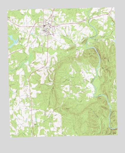
Woodbury, GA USGS Topographic Map
Click on map above to begin viewing in our Map Viewer.

This topographic map contains these locations and features:
Feature Name Type Latitude Longitude GNIS ID View Map
Alford CemeteryCemeteryN32.9282°W84.5310°310436View Map
Alford School (historical)SchoolN32.9307°W84.5349°346831View Map
Antioch Baptist ChurchChurchN32.9924°W84.6246°354348View Map
Bethesda CemeteryCemeteryN32.8926°W84.5985°346834View Map
Bethesda School (historical)SchoolN32.8907°W84.5985°346835View Map
Bethesda United Methodist ChurchChurchN32.8912°W84.5983°346836View Map
BettsPopulated PlaceN32.9518°W84.5874°331151View Map
Betts MountainSummitN32.9182°W84.5733°331152View Map
Bowman CemeteryCemeteryN32.9290°W84.5549°311681View Map
Buck CreekStreamN32.9160°W84.5266°311950View Map
Buzzard RoostSummitN32.9671°W84.5366°331299View Map
Campbell School (historical)SchoolN32.8829°W84.5944°346844View Map
Cane CreekStreamN32.9604°W84.5324°312288View Map
Cane Creek Structure Number Two DamDamN32.9685°W84.6133°337519View Map
Cane Creek Structure Number Two LakeReservoirN32.9649°W84.6205°337520View Map
Carroll DamDamN32.9768°W84.5966°340224View Map
Carroll LakeReservoirN32.9764°W84.5970°340225View Map
Cedar Tree HollowValleyN32.8919°W84.5204°312501View Map
City of WoodburyCivilN32.9848°W84.5821°2405781View Map
Concord CemeteryCemeteryN32.9698°W84.5702°312881View Map
CoveLocaleN32.9290°W84.5360°355351View Map
Cove ChurchChurchN32.9299°W84.5352°346855View Map
Dixon MountainSummitN32.9612°W84.5502°331563View Map
Double BranchStreamN32.9485°W84.5183°313560View Map
Dripping RocksCliffN32.9568°W84.5199°313626View Map
Ebenezer CemeteryCemeteryN32.8779°W84.5988°313814View Map
Eberneza Primitive Baptist Church (historical)ChurchN32.8776°W84.5991°346859View Map
Eberneza School (historical)SchoolN32.8774°W84.5991°346860View Map
Elkins CreekStreamN32.9704°W84.5271°355671View Map
Flint River AcademySchoolN32.9924°W84.5717°314227View Map
Fuller HollowValleyN32.9012°W84.5094°314452View Map
George E Washington Elementary SchoolSchoolN32.9859°W84.5765°346935View Map
Gilbert CemeteryCemeteryN32.9385°W84.5388°314588View Map
Girard FordCrossingN32.9193°W84.5244°346866View Map
Goat MountainSummitN32.8976°W84.5044°331825View Map
Halls Bridge (historical)BridgeN32.9851°W84.5305°346874View Map
Hardy BranchStreamN32.8818°W84.5030°315125View Map
Harris BranchStreamN32.9249°W84.6071°315175View Map
Holy Hill ChurchChurchN32.9671°W84.5146°346720View Map
Huckleberry PinnacleSummitN32.9018°W84.5596°332039View Map
Iron BridgeBridgeN32.9896°W84.5288°346876View Map
Johnson CrossroadsPopulated PlaceN32.9012°W84.5991°326345View Map
Keenan HollowValleyN32.9040°W84.5805°316333View Map
Kingdom HallChurchN32.9071°W84.5985°316439View Map
Knights BranchStreamN32.9910°W84.5291°316498View Map
LangdonPopulated PlaceN32.9454°W84.6008°332183View Map
LoftinPopulated PlaceN32.8851°W84.5980°332255View Map
Long BranchStreamN32.9054°W84.5066°317331View Map
Manchester DivisionCivilN32.9024°W84.5880°1936389View Map
Matt BranchStreamN32.9421°W84.5208°317796View Map
Melton FordCrossingN32.9390°W84.5230°346891View Map
Meriwether County Volunteer Fire Department Station 9BuildingN32.9451°W84.5429°2604985View Map
Mill CreekStreamN32.9435°W84.6113°318199View Map
Mount Pleasant CemeteryCemeteryN32.9243°W84.6021°318823View Map
Mount Pleasant Congregational Church (historical)ChurchN32.9240°W84.6021°346899View Map
Muddy Slash RidgeRidgeN32.9307°W84.5069°319131View Map
Pappys CreekStreamN32.9965°W84.5308°320191View Map
PersicoPopulated PlaceN32.9154°W84.6041°332644View Map
Pigeon CreekStreamN32.8904°W84.5096°320507View Map
Pigpen HollowValleyN32.8905°W84.5833°320511View Map
Pilgrims Rest ChurchChurchN32.9265°W84.6221°320529View Map
Pleasant ValleyValleyN32.9145°W84.5016°320932View Map
Pleasant Valley ChurchChurchN32.9171°W84.5049°320936View Map
Pleasant Valley School (historical)SchoolN32.9168°W84.5049°346737View Map
Pound CreekStreamN32.9546°W84.5988°321101View Map
Powell BranchStreamN32.9604°W84.5863°321109View Map
Riggins Bridge (historical)BridgeN32.9646°W84.5341°346914View Map
Riggins CemeteryCemeteryN32.9648°W84.5269°321606View Map
Rockhouse MountainSummitN32.8760°W84.5041°321772View Map
See CemeteryCemeteryN32.8893°W84.5777°322699View Map
Sees Old MillLocaleN32.9407°W84.5902°322700View Map
Sheep Rock HollowStreamN32.9229°W84.5380°322816View Map
Singers HillSummitN32.9112°W84.5208°333061View Map
Spring CreekStreamN32.9726°W84.5055°323379View Map
Tarver BranchStreamN32.9607°W84.5421°323925View Map
The CoveBasinN32.9312°W84.5474°324040View Map
Thompson CemeteryCemeteryN32.9918°W84.5185°324109View Map
Turpentine BranchStreamN32.8837°W84.5099°324426View Map
Waddell CemeteryCemeteryN32.9251°W84.5438°324734View Map
Ware CemeteryCemeteryN32.9896°W84.6216°324845View Map
West Brown CemeteryCemeteryN32.9160°W84.5555°346932View Map
WFDR-AM (Manchester)TowerN32.8874°W84.5983°352487View Map
White Plains CemeteryCemeteryN32.9962°W84.5041°346472View Map
White Plains ChurchChurchN32.9962°W84.5038°325184View Map
White Plains School (historical)SchoolN32.9965°W84.5041°346473View Map
WoodburyPopulated PlaceN32.9837°W84.5827°333457View Map
Woodbury DivisionCivilN32.9928°W84.5986°1936654View Map
Woodbury High SchoolSchoolN32.9751°W84.5752°346936View Map
Woodbury Police DepartmentBuildingN32.9834°W84.5824°2733520View Map
Woodbury Volunteer Fire Department Station 13BuildingN32.9831°W84.5825°2604829View Map
Woodbury WaterworksLocaleN32.9707°W84.6099°344386View Map
Wright BranchStreamN32.9343°W84.5221°325569View Map

Note: Coordinates in the location and feature list above are referenced to NAD83 datum.


Copyright (C) 2008-2024 Ryan Niemi / Sunset Dynamics ... All Rights Reserved