TopoQuest Logo
Do you find TopoQuest useful?
Help keep TopoQuest running and adding new maps/features by donating!
Bitcoin:  19c7KJd3qBynnjoSw5npx9KScwjBe4ifkT
Litecoin:  LXs6TkuXGGXo1vDsWCkWVdjQX94eUKd6ui
Home View Maps Find Maps Find Places Resources & Links


Warm Springs, Georgia Topographic Map

USGS Map Title: Warm Springs, GA
USGS Map MRC: 32084H6
DRG (GeoTIFF) Download: o32084h6.tif


Neighboring USGS Topographic Map Quads:


  Odessadale, GA  
33084A7
 

  Greenville, GA  
33084A6
 

  Gay, GA  
33084A5
 

  Durand, GA  
32084H7
 

  Warm Springs, GA  
32084H6
 

  Woodbury, GA  
32084H5
 

  Pine Mountain, GA  
32084G7
 

  Shiloh, GA  
32084G6
 

  Manchester, GA  
32084G5


Map MRC Location:

N33°
W85°
N33°
W84°
H8 H7 H6 H5 H4 H3 H2 H1
G8 G7 G6 G5 G4 G3 G2 G1
F8 F7 F6 F5 F4 F3 F2 F1
E8 E7 E6 E5 E4 E3 E2 E1
D8 D7 D6 D5 D4 D3 D2 D1
C8 C7 C6 C5 C4 C3 C2 C1
B8 B7 B6 B5 B4 B3 B2 B1
A8 A7 A6 A5 A4 A3 A2 A1
N32°
W85°
N32°
W84°

Warm Springs, GA USGS 1:24K Topographic Map Preview:
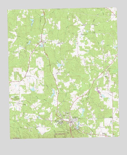
Warm Springs, GA USGS Topographic Map
Click on map above to begin viewing in our Map Viewer.

This topographic map contains these locations and features:
Feature Name Type Latitude Longitude GNIS ID View Map
Adcock DamDamN32.9768°W84.6599°340214View Map
Adcock LakeReservoirN32.9777°W84.6591°340215View Map
Andrews CrossroadsPopulated PlaceN32.9835°W84.6610°331042View Map
Barnes CemeteryCemeteryN32.9673°W84.6883°346833View Map
Barnes CrossroadsPopulated PlaceN32.9671°W84.6902°331092View Map
Berner LakeReservoirN32.9226°W84.7229°337534View Map
Berner Lake DamDamN32.9218°W84.7216°337533View Map
Brae-Tarn LakeReservoirN32.9172°W84.6999°346839View Map
Brooks CemeteryCemeteryN32.9535°W84.6374°311828View Map
Bullochville (historical)Populated PlaceN32.8935°W84.6533°346840View Map
Bussey CrossroadsPopulated PlaceN32.8771°W84.6441°354921View Map
Cane Creek ChurchChurchN32.9765°W84.6505°354978View Map
Cane Creek Structure Number Five DamDamN32.9201°W84.6983°337523View Map
Cane Creek Structure Number Five LakeReservoirN32.9201°W84.6983°337524View Map
Cane Creek Structure Number Four DamDamN32.9018°W84.6649°340324View Map
Cane Creek Structure Number Four LakeReservoirN32.8999°W84.6658°340325View Map
Cane Creek Structure Number Three DamDamN32.9451°W84.6883°337521View Map
Cane Creek Structure Number Three LakeReservoirN32.9457°W84.6915°337522View Map
Cascade BranchStreamN32.8874°W84.6983°312399View Map
Cedar Rock ChurchChurchN32.9835°W84.6508°312492View Map
Cedar Rock School (historical)SchoolN32.9835°W84.6508°346848View Map
City of Warm SpringsCivilN32.8852°W84.6766°2405672View Map
Crowders CrossingPopulated PlaceN32.9354°W84.7313°331488View Map
Davis Memorial Lookout TowerTowerN32.8760°W84.6902°355450View Map
E H Hutton Airstrip (historical)AirportN32.9162°W84.6349°346858View Map
Florence BranchStreamN32.8921°W84.7430°314233View Map
Handco BranchStreamN32.9454°W84.6919°315083View Map
Harmony ChurchChurchN32.9407°W84.6913°315144View Map
Harris CemeteryCemeteryN32.9118°W84.6602°315184View Map
Harris CityPopulated PlaceN32.9682°W84.7127°356205View Map
Hill LakeReservoirN32.9856°W84.7219°315413View Map
Hill Lake DamDamN32.9904°W84.7208°340220View Map
Hinton BranchStreamN32.9965°W84.6419°315457View Map
Hudson LakeReservoirN32.9148°W84.6424°315790View Map
Jacks CreekStreamN32.9365°W84.6577°315988View Map
James LakeReservoirN32.9680°W84.7255°316043View Map
James Lake DamDamN32.9696°W84.7247°340218View Map
Judson-Bulloch CemeteryCemeteryN32.8848°W84.6460°316295View Map
Lower Hudson LakeReservoirN32.9186°W84.6473°337530View Map
Lower Hudson Lake DamDamN32.9201°W84.6483°337529View Map
McLendon CrossroadsPopulated PlaceN32.9926°W84.6266°332357View Map
Meriwether County Emergency Medical ServicesBuildingN32.8870°W84.6807°2625462View Map
Meriwether SpringSpringN32.9151°W84.7439°318043View Map
Mount Hope BranchStreamN32.8937°W84.7369°318663View Map
Mount Hope ChurchChurchN32.8865°W84.7188°318667View Map
Mountain View Elementary SchoolSchoolN32.8821°W84.6471°2545634View Map
Peoples BranchStreamN32.9171°W84.6997°320371View Map
Philipps LakeReservoirN32.9643°W84.7115°340217View Map
Phillips DamDamN32.9640°W84.7102°340216View Map
RaleighPopulated PlaceN32.9368°W84.6363°332785View Map
Rocky Ford BranchStreamN32.9185°W84.6846°321841View Map
Roosevelt Memorial AirportAirportN32.9352°W84.6974°351945View Map
Roosevelt Warm Springs Institute for RehabilitationHospitalN32.8911°W84.6896°2611003View Map
Routons CrossroadsPopulated PlaceN32.8935°W84.6324°326500View Map
Salem Baptist ChurchChurchN32.9299°W84.6360°346917View Map
Silone ChurchChurchN32.9607°W84.7194°322981View Map
Snelsons CrossroadsPopulated PlaceN32.9751°W84.6663°333081View Map
The Little White HouseBuildingN32.8815°W84.6874°324050View Map
Union Hill ChurchChurchN32.9385°W84.6360°346926View Map
Union Hill School (historical)SchoolN32.9576°W84.7080°346927View Map
Upper Hudson LakeReservoirN32.9151°W84.6451°340056View Map
Upper Hudson Lake DamDamN32.9151°W84.6449°340055View Map
Ward CemeteryCemeteryN32.9093°W84.7391°324834View Map
Ward LakeReservoirN32.8956°W84.7163°324839View Map
Warm SpringsSpringN32.8935°W84.6899°324850View Map
Warm SpringsPopulated PlaceN32.8904°W84.6810°324851View Map
Warm Springs BranchStreamN32.9346°W84.6641°324852View Map
Warm Springs CampgroundLocaleN32.9140°W84.7433°324853View Map
Warm Springs Elementary SchoolSchoolN32.8868°W84.6805°346930View Map
Warm Springs Fire DepartmentBuildingN32.8870°W84.6807°2603847View Map
Warm Springs Fish Technology CenterParkN32.8848°W84.6724°2765551View Map
Warm Springs FoundationBuildingN32.8901°W84.6902°324854View Map
Warm Springs Historic DistrictParkN32.8904°W84.6813°346931View Map
Warm Springs Medical CenterHospitalN32.8893°W84.6832°346896View Map
Warm Springs National Fish HatcheryParkN32.8865°W84.6723°344379View Map
Warm Springs Police DepartmentBuildingN32.8865°W84.6805°2733758View Map
Williams ChapelChurchN32.8990°W84.6849°325345View Map

Note: Coordinates in the location and feature list above are referenced to NAD83 datum.


Copyright (C) 2008-2025 Ryan Niemi / Sunset Dynamics ... All Rights Reserved