TopoQuest Logo
Do you find TopoQuest useful?
Help keep TopoQuest running and adding new maps/features by donating!
Bitcoin:  19c7KJd3qBynnjoSw5npx9KScwjBe4ifkT
Litecoin:  LXs6TkuXGGXo1vDsWCkWVdjQX94eUKd6ui
Home View Maps Find Maps Find Places Resources & Links


Zwolle, Louisiana Topographic Map

USGS Map Title: Zwolle, LA
USGS Map MRC: 31093F6
DRG (GeoTIFF) Download: o31093f6.tif


Neighboring USGS Topographic Map Quads:


  Union Springs, LA  
31093G7
 

  Converse, LA  
31093G6
 

  Pleasant Hill, LA  
31093G5
 

  Brushy Creek, TX  
31093F7
 

  Zwolle, LA  
31093F6
 

  Belmont, LA  
31093F5
 

  East Hamilton, TX  
31093E7
 

  Beech Bayou, LA  
31093E6
 

  Loring, LA  
31093E5


Map MRC Location:

N32°
W94°
N32°
W93°
H8 H7 H6 H5 H4 H3 H2 H1
G8 G7 G6 G5 G4 G3 G2 G1
F8 F7 F6 F5 F4 F3 F2 F1
E8 E7 E6 E5 E4 E3 E2 E1
D8 D7 D6 D5 D4 D3 D2 D1
C8 C7 C6 C5 C4 C3 C2 C1
B8 B7 B6 B5 B4 B3 B2 B1
A8 A7 A6 A5 A4 A3 A2 A1
N31°
W94°
N31°
W93°

Zwolle, LA USGS 1:24K Topographic Map Preview:
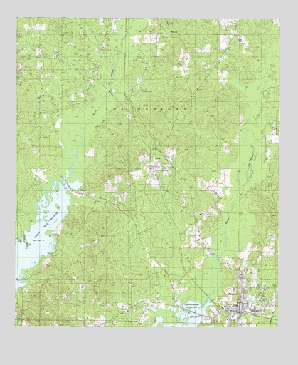
Zwolle, LA USGS Topographic Map
Click on map above to begin viewing in our Map Viewer.

This topographic map contains these locations and features:
Feature Name Type Latitude Longitude GNIS ID View Map
Bapsilene School (historical)SchoolN31.7296°W93.7380°549489View Map
Brown CemeteryCemeteryN31.7127°W93.7307°533435View Map
Cassel CemeteryCemeteryN31.7241°W93.7491°533805View Map
ClydePopulated PlaceN31.6418°W93.6752°1630454View Map
Clyde CemeteryCemeteryN31.6429°W93.6727°534009View Map
Clyde School (historical)SchoolN31.6621°W93.7113°546093View Map
Derby BranchStreamN31.6735°W93.7249°546099View Map
Ebarb School Oil and Gas FieldOilfieldN31.6405°W93.7410°546101View Map
First Baptist ChurchChurchN31.6346°W93.6430°557918View Map
NoblePopulated PlaceN31.6896°W93.6841°537692View Map
Noble CemeteryCemeteryN31.6882°W93.6949°537693View Map
Noble Post OfficePost OfficeN31.6904°W93.6866°1630481View Map
North Sabine Fire Protection District Noble Station 1BuildingN31.6904°W93.6856°2673103View Map
North Sabine Fire Protection District Noble Station 2BuildingN31.6905°W93.6867°2673104View Map
North Sabine Volunteer Fire Protection DistrictBuildingN31.6327°W93.6432°2672904View Map
Parrott CemeteryCemeteryN31.6832°W93.6307°537985View Map
Saint Josephs Catholic ChurchChurchN31.6330°W93.6518°557924View Map
Saline ChurchChurchN31.7299°W93.7385°539102View Map
Saline Industrial Institute (historical)SchoolN31.7288°W93.7382°546176View Map
San Patricio ChurchChurchN31.7363°W93.7419°539124View Map
Sardis CemeteryCemeteryN31.7460°W93.6338°539178View Map
Sardis Church (historical)ChurchN31.7460°W93.6324°546181View Map
Shiloh CemeteryCemeteryN31.7329°W93.6741°539336View Map
Shiloh Church (historical)ChurchN31.7324°W93.6716°546182View Map
Town of ZwolleCivilN31.6398°W93.6413°2406931View Map
Village of NobleCivilN31.6899°W93.6832°2407511View Map
Ward EightCivilN31.6430°W93.6274°545201View Map
ZwollePopulated PlaceN31.6316°W93.6441°540611View Map
Zwolle City Police DepartmentBuildingN31.6306°W93.6431°2755329View Map
Zwolle Elementary SchoolSchoolN31.6343°W93.6454°546204View Map
Zwolle High SchoolSchoolN31.6343°W93.6463°546205View Map
Zwolle Intermediate School (historical)SchoolN31.6347°W93.6449°546206View Map

Note: Coordinates in the location and feature list above are referenced to NAD83 datum.


Copyright (C) 2008-2025 Ryan Niemi / Sunset Dynamics ... All Rights Reserved