TopoQuest Logo
Do you find TopoQuest useful?
Help keep TopoQuest running and adding new maps/features by donating!
Bitcoin:  19c7KJd3qBynnjoSw5npx9KScwjBe4ifkT
Litecoin:  LXs6TkuXGGXo1vDsWCkWVdjQX94eUKd6ui
Home View Maps Find Maps Find Places Resources & Links


East Hamilton, Texas Topographic Map

USGS Map Title: East Hamilton, TX
USGS Map MRC: 31093E7
DRG (GeoTIFF) Download: o31093e7.tif


Neighboring USGS Topographic Map Quads:


  Patroon North, TX  
31093F8
 

  Brushy Creek, TX  
31093F7
 

  Zwolle, LA  
31093F6
 

  Patroon South, TX  
31093E8
 

  East Hamilton, TX  
31093E7
 

  Beech Bayou, LA  
31093E6
 

  Geneva, TX  
31093D8
 

  Milam, TX  
31093D7
 

  Salter Creek, LA  
31093D6


Map MRC Location:

N32°
W94°
N32°
W93°
H8 H7 H6 H5 H4 H3 H2 H1
G8 G7 G6 G5 G4 G3 G2 G1
F8 F7 F6 F5 F4 F3 F2 F1
E8 E7 E6 E5 E4 E3 E2 E1
D8 D7 D6 D5 D4 D3 D2 D1
C8 C7 C6 C5 C4 C3 C2 C1
B8 B7 B6 B5 B4 B3 B2 B1
A8 A7 A6 A5 A4 A3 A2 A1
N31°
W94°
N31°
W93°

East Hamilton, TX USGS 1:24K Topographic Map Preview:
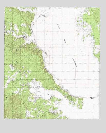
East Hamilton, TX USGS Topographic Map
Click on map above to begin viewing in our Map Viewer.

This topographic map contains these locations and features:
Feature Name Type Latitude Longitude GNIS ID View Map
Alford CemeteryCemeteryN31.5233°W93.8125°2575474View Map
Ball IslandIslandN31.5841°W93.8141°546995View Map
Bayou San PatricioStreamN31.6146°W93.8185°554137View Map
Bennetts CemeteryCemeteryN31.5632°W93.8394°1381393View Map
Black LakeLakeN31.5491°W93.8016°547094View Map
Blue Lake School (historical)SchoolN31.5724°W93.7660°546081View Map
Bone RidgeRidgeN31.5902°W93.8288°547119View Map
Bourghs CreekStreamN31.5432°W93.8538°1381490View Map
Braggs ChurchChurchN31.5191°W93.7724°1383774View Map
Brittain CreekStreamN31.6227°W93.8457°1381516View Map
Brushy LakeLakeN31.5696°W93.8152°547139View Map
Buzzard LakeLakeN31.5818°W93.8255°547158View Map
Chamber Ferry (historical)CrossingN31.5471°W93.8088°546088View Map
Cox BranchStreamN31.5885°W93.8471°1381711View Map
Darnell Ferry (historical)CrossingN31.6146°W93.8196°546098View Map
Donnell LakeLakeN31.6132°W93.8274°547302View Map
Dorsey BranchStreamN31.5310°W93.8238°1381782View Map
East HamiltonPopulated PlaceN31.5960°W93.8419°1381818View Map
East Hamilton Boat Ramp Recreation SiteLocaleN31.5966°W93.8396°1383772View Map
East Hamilton ChurchChurchN31.6071°W93.8669°1381819View Map
Harvey CemeteryCemeteryN31.5418°W93.8505°1381977View Map
Holmes River LakeLakeN31.5593°W93.8166°547472View Map
Horseshoe LakeLakeN31.6043°W93.8335°547481View Map
IslaPopulated PlaceN31.5052°W93.8455°1889819View Map
Lewis BranchStreamN31.5924°W93.8541°1382142View Map
Liberty Springs CemeteryCemeteryN31.5122°W93.8281°2575507View Map
Liberty Springs ChurchChurchN31.5132°W93.8280°1382149View Map
Liberty Springs United Methodist ChurchChurchN31.5136°W93.8281°2575508View Map
Martinez BayouStreamN31.5985°W93.8705°1382234View Map
Mason CemeteryCemeteryN31.5099°W93.8302°1382237View Map
Mason CreekStreamN31.5049°W93.7955°1382238View Map
McGuire CemeteryCemeteryN31.5606°W93.8744°2575519View Map
Moran-Loving CemeteryCemeteryN31.5219°W93.7714°2575526View Map
Mount Olive ChurchChurchN31.5399°W93.8591°1382343View Map
Patroon Bayou Recreation AreaLocaleN31.5602°W93.8721°1383773View Map
Reeves CreekStreamN31.5352°W93.8416°1382611View Map
Round PondLakeN31.5743°W93.8182°547917View Map
Saltworks LakeLakeN31.5402°W93.7982°547948View Map
Sandy SloughGutN31.6216°W93.8082°547969View Map
Shamrock Shores Volunteer Fire DepartmentBuildingN31.5224°W93.7858°2655508View Map
Strother CemeteryCemeteryN31.5353°W93.8494°2575543View Map
Vines Old River LakeLakeN31.5296°W93.7577°548119View Map
Webb LakeLakeN31.5663°W93.8188°548131View Map
Wilson CreekStreamN31.6202°W93.8263°1382981View Map

Note: Coordinates in the location and feature list above are referenced to NAD83 datum.


Copyright (C) 2008-2025 Ryan Niemi / Sunset Dynamics ... All Rights Reserved