TopoQuest Logo
Do you find TopoQuest useful?
Help keep TopoQuest running and adding new maps/features by donating!
Bitcoin:  19c7KJd3qBynnjoSw5npx9KScwjBe4ifkT
Litecoin:  LXs6TkuXGGXo1vDsWCkWVdjQX94eUKd6ui
Home View Maps Find Maps Find Places Resources & Links


Capps Springs, Colorado Topographic Map

USGS Map Title: Capps Springs, CO
USGS Map MRC: 37104G5
DRG (GeoTIFF) Download: o37104g5.tif


Neighboring USGS Topographic Map Quads:


  Graneros Flats, CO  
37104H6
 

  Cedarwood, CO  
37104H5
 

  Hog Ranch Canyon, CO  
37104H4
 

  Lascar, CO  
37104G6
 

  Capps Springs, CO  
37104G5
 

  North Rattlesnake Butte, CO  
37104G4
 

  Maria Reservoir, CO  
37104F6
 

  Cucharas Reservoir, CO  
37104F5
 

  South Rattlesnake Butte, CO  
37104F4


Map MRC Location:

N38°
W105°
N38°
W104°
H8 H7 H6 H5 H4 H3 H2 H1
G8 G7 G6 G5 G4 G3 G2 G1
F8 F7 F6 F5 F4 F3 F2 F1
E8 E7 E6 E5 E4 E3 E2 E1
D8 D7 D6 D5 D4 D3 D2 D1
C8 C7 C6 C5 C4 C3 C2 C1
B8 B7 B6 B5 B4 B3 B2 B1
A8 A7 A6 A5 A4 A3 A2 A1
N37°
W105°
N37°
W104°

Capps Springs, CO USGS 1:24K Topographic Map Preview:
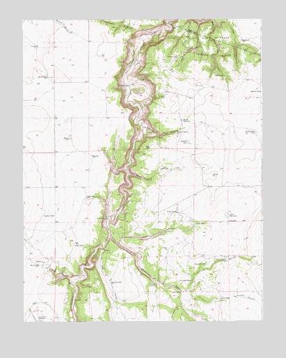
Capps Springs, CO USGS Topographic Map
Click on map above to begin viewing in our Map Viewer.

This topographic map contains these locations and features:
Feature Name Type Latitude Longitude GNIS ID View Map
Albright WellWellN37.7733°W104.6172°194084View Map
Bobcat CanyonValleyN37.7675°W104.6004°194085View Map
Briscoe TankReservoirN37.7956°W104.5449°194089View Map
Bull SpringSpringN37.8517°W104.5203°194105View Map
Capps SpringsSpringN37.7658°W104.5555°194076View Map
Cat CanyonValleyN37.8745°W104.5177°194106View Map
Collins PitReservoirN37.8106°W104.5262°194092View Map
Cuchara Ranch AirportAirportN37.7873°W104.5932°2443970View Map
Daley TankReservoirN37.8220°W104.5586°194095View Map
East WellWellN37.8186°W104.5886°194094View Map
Emma Paul CanyonValleyN37.8109°W104.5698°194093View Map
Fisher PitReservoirN37.7801°W104.5494°194081View Map
Goodrich TankReservoirN37.7939°W104.6087°194087View Map
Haley LakeReservoirN37.7817°W104.5986°194086View Map
Hall WellWellN37.8642°W104.6175°194111View Map
Hamilton CanyonValleyN37.7596°W104.5374°194071View Map
Hauser LakeLakeN37.8258°W104.6006°194098View Map
Heibuhr WellWellN37.8014°W104.5922°194088View Map
Kenner DamDamN37.7753°W104.5205°194079View Map
Kenner RanchLocaleN37.8433°W104.5525°194103View Map
Kenner WellWellN37.7603°W104.5139°194080View Map
Keystone CanyonValleyN37.8301°W104.5622°194099View Map
Keystone DamDamN37.8245°W104.5397°194096View Map
Keystone SpringSpringN37.8286°W104.5444°194097View Map
Lost LakeReservoirN37.8717°W104.5443°194108View Map
Lower Deus LakeLakeN37.7938°W104.5186°194091View Map
Rattlesnake CanyonValleyN37.7853°W104.5800°194072View Map
Rattlesnake WellWellN37.7658°W104.5794°194074View Map
Salyers ReservoirReservoirN37.7912°W104.5179°194090View Map
School Section LakeLakeN37.8282°W104.5035°194101View Map
Shoemaker SpringSpringN37.7670°W104.5369°194077View Map
Shoemaker TankReservoirN37.7736°W104.5293°194078View Map
Starbuck LakeReservoirN37.8449°W104.5007°194102View Map
Starbuck WellWellN37.8511°W104.6122°194110View Map
Tryon CanyonValleyN37.7627°W104.5398°194070View Map
Turkey RidgeRidgeN37.8675°W104.5489°203707View Map
Turkey TankReservoirN37.8590°W104.5441°194109View Map
Vigil CanyonValleyN37.7806°W104.5837°194073View Map
Vigil SpringSpringN37.7622°W104.5430°194075View Map
West Turkey CanyonValleyN37.8738°W104.5330°194107View Map
Wilson CrossingLocaleN37.8478°W104.5697°194104View Map
Wyatt ReservoirReservoirN37.8331°W104.5414°194100View Map
Yoeman CanyonValleyN37.7821°W104.5750°194082View Map
Yoeman TankReservoirN37.7899°W104.5351°194083View Map

Note: Coordinates in the location and feature list above are referenced to NAD83 datum.


Copyright (C) 2008-2025 Ryan Niemi / Sunset Dynamics ... All Rights Reserved