TopoQuest Logo
Do you find TopoQuest useful?
Help keep TopoQuest running and adding new maps/features by donating!
Bitcoin:  19c7KJd3qBynnjoSw5npx9KScwjBe4ifkT
Litecoin:  LXs6TkuXGGXo1vDsWCkWVdjQX94eUKd6ui
Home View Maps Find Maps Find Places Resources & Links


Lake City East, South Carolina Topographic Map

USGS Map Title: Lake City East, SC
USGS Map MRC: 33079G6
DRG (GeoTIFF) Download: o33079g6.tif


Neighboring USGS Topographic Map Quads:


  Mill Bay, SC  
33079H7
 

  Scranton, SC  
33079H6
 

  Pamplico South, SC  
33079H5
 

  Lake City West, SC  
33079G7
 

  Lake City East, SC  
33079G6
 

  Prospect Crossroads, SC  
33079G5
 

  Kingstree, SC  
33079F7
 

  Fowler, SC  
33079F6
 

  Indiantown, SC  
33079F5


Map MRC Location:

N34°
W80°
N34°
W79°
H8 H7 H6 H5 H4 H3 H2 H1
G8 G7 G6 G5 G4 G3 G2 G1
F8 F7 F6 F5 F4 F3 F2 F1
E8 E7 E6 E5 E4 E3 E2 E1
D8 D7 D6 D5 D4 D3 D2 D1
C8 C7 C6 C5 C4 C3 C2 C1
B8 B7 B6 B5 B4 B3 B2 B1
A8 A7 A6 A5 A4 A3 A2 A1
N33°
W80°
N33°
W79°

Lake City East, SC USGS 1:24K Topographic Map Preview:
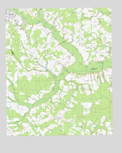
Lake City East, SC USGS Topographic Map
Click on map above to begin viewing in our Map Viewer.

This topographic map contains these locations and features:
Feature Name Type Latitude Longitude GNIS ID View Map
Askins PondReservoirN33.8118°W79.6998°1240109View Map
Askins Pond Dam D-3574DamN33.8118°W79.6998°1240108View Map
Bethel ChurchChurchN33.8407°W79.6601°1242313View Map
Bethel SchoolSchoolN33.8410°W79.6603°1220585View Map
Bethesda ChurchChurchN33.7624°W79.6790°1241375View Map
Bethesda ChurchChurchN33.7716°W79.7123°1246811View Map
Bethesda School (historical)SchoolN33.7621°W79.6728°1246817View Map
Bethlehem ChurchChurchN33.8452°W79.7092°1220612View Map
Beulah ChurchChurchN33.8243°W79.7426°1241377View Map
Beulah SchoolSchoolN33.8252°W79.7428°1220646View Map
Brown CemeteryCemeteryN33.8252°W79.6334°1242332View Map
Brown ChapelChurchN33.8316°W79.6315°1247005View Map
Browns BridgeBridgeN33.8196°W79.6356°1242333View Map
Browns Chapel CemeteryCemeteryN33.8313°W79.6309°1242334View Map
Browns School (historical)SchoolN33.8304°W79.6362°1242335View Map
Browns Store (historical)LocaleN33.8310°W79.6306°1242336View Map
Central Holiness ChurchChurchN33.8594°W79.7379°2490162View Map
Cooper CemeteryCemeteryN33.7579°W79.6281°1221738View Map
Eaddy PondReservoirN33.8368°W79.6265°1240107View Map
Eaddy Pond Dam D-3575DamN33.8368°W79.6265°1240106View Map
East Lake City Holiness ChurchChurchN33.8663°W79.6782°1242048View Map
Gaskin CemeteryCemeteryN33.8299°W79.6728°1241922View Map
Gaskins SchoolSchoolN33.8310°W79.6992°1222658View Map
Grahams Mill BranchStreamN33.7835°W79.7348°1227855View Map
Jones CemeteryCemeteryN33.8163°W79.7053°1241999View Map
Kelley HeightsPopulated PlaceN33.8629°W79.7465°1241990View Map
Lake City Wastewater Treatment PlantLocaleN33.8649°W79.7299°2490484View Map
Lake City-Scranton DivisionCivilN33.8673°W79.6993°1938320View Map
Lake Point United Methodist ChurchChurchN33.8163°W79.6813°2490171View Map
Lee CrossroadsPopulated PlaceN33.8716°W79.6662°1246323View Map
Liberty ChurchChurchN33.8616°W79.6437°1229901View Map
Liberty School (historical)SchoolN33.8613°W79.6437°1242025View Map
Lions Municipal PArkParkN33.8738°W79.7456°1242026View Map
Long BranchStreamN33.8054°W79.6878°1253451View Map
Lynch CemeteryCemeteryN33.8152°W79.6962°1242031View Map
Main Street Elementary SchoolSchoolN33.8711°W79.7484°2486467View Map
Martha Law EstatesPopulated PlaceN33.8593°W79.7290°1242042View Map
Martha Law Municipal ParkParkN33.8624°W79.7276°1242043View Map
McCutcheon School (historical)SchoolN33.8660°W79.6781°1242049View Map
McNamee SwampStreamN33.7793°W79.7206°1227795View Map
New Zion Missionary Baptist ChurchChurchN33.8654°W79.6647°1242262View Map
Ninevah Church (historical)ChurchN33.8313°W79.6303°1242091View Map
Ninevah School (historical)SchoolN33.8313°W79.6303°1242092View Map
Paran ChurchChurchN33.8346°W79.7040°1250018View Map
Pentecostal Holiness ChurchChurchN33.8735°W79.7490°1242126View Map
Pine Grove School (historical)SchoolN33.7643°W79.7167°1241488View Map
Roper School (historical)SchoolN33.8079°W79.6667°1241494View Map
Rough Branch School (historical)SchoolN33.7718°W79.7123°1241495View Map
Saint John ChurchChurchN33.8074°W79.6640°1226131View Map
Saint Mark ChurchChurchN33.8596°W79.6534°1250586View Map
Singleton ChurchChurchN33.8082°W79.6384°1241518View Map
Singleton School (historical)SchoolN33.8079°W79.6387°1241519View Map
Singleton SwampStreamN33.8154°W79.6556°1226647View Map
Smith SwampStreamN33.7793°W79.7203°1250937View Map
South Lynches Fire Department Station 5BuildingN33.8467°W79.6704°2368364View Map
WJOT-AM (Lake City)TowerN33.8618°W79.7373°1252378View Map
Wren VillagePopulated PlaceN33.8588°W79.7367°1242259View Map
Wren Village Municipal ParkParkN33.8638°W79.7398°1242260View Map
Zion SchoolSchoolN33.8666°W79.6642°1227769View Map

Note: Coordinates in the location and feature list above are referenced to NAD83 datum.


Copyright (C) 2008-2025 Ryan Niemi / Sunset Dynamics ... All Rights Reserved