TopoQuest Logo
Do you find TopoQuest useful?
Help keep TopoQuest running and adding new maps/features by donating!
Bitcoin:  19c7KJd3qBynnjoSw5npx9KScwjBe4ifkT
Litecoin:  LXs6TkuXGGXo1vDsWCkWVdjQX94eUKd6ui
Home View Maps Find Maps Find Places Resources & Links


Carlisle, New York Topographic Map

USGS Map Title: Carlisle, NY
USGS Map MRC: 42074G4
DRG (GeoTIFF) Download: o42074g4.tif


Neighboring USGS Topographic Map Quads:


  Canajoharie, NY  
42074H5
 

  Randall, NY  
42074H4
 

  Tribes Hill, NY  
42074H3
 

  Sharon Springs, NY  
42074G5
 

  Carlisle, NY  
42074G4
 

  Esperance, NY  
42074G3
 

  Richmondville, NY  
42074F5
 

  Cobleskill, NY  
42074F4
 

  Schoharie, NY  
42074F3


Map MRC Location:

N43°
W75°
N43°
W74°
H8 H7 H6 H5 H4 H3 H2 H1
G8 G7 G6 G5 G4 G3 G2 G1
F8 F7 F6 F5 F4 F3 F2 F1
E8 E7 E6 E5 E4 E3 E2 E1
D8 D7 D6 D5 D4 D3 D2 D1
C8 C7 C6 C5 C4 C3 C2 C1
B8 B7 B6 B5 B4 B3 B2 B1
A8 A7 A6 A5 A4 A3 A2 A1
N42°
W75°
N42°
W74°

Carlisle, NY USGS 1:24K Topographic Map Preview:
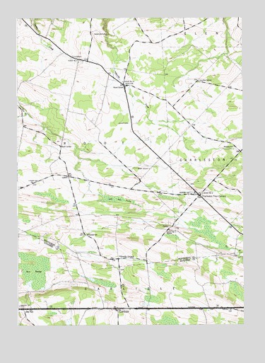
Carlisle, NY USGS Topographic Map
Click on map above to begin viewing in our Map Viewer.

This topographic map contains these locations and features:
Feature Name Type Latitude Longitude GNIS ID View Map
Bear SwampSwampN42.7737°W74.4962°969854View Map
Bonesteel School (historical)SchoolN42.7867°W74.4624°944426View Map
Bratt School (historical)SchoolN42.8137°W74.4271°944658View Map
Buttermilk FallsFallsN42.8687°W74.4507°945366View Map
CarlislePopulated PlaceN42.7570°W74.4457°945841View Map
Carlisle CemeteryCemeteryN42.7599°W74.4515°2554825View Map
Carlisle Volunteer Fire DepartmentBuildingN42.7572°W74.4453°2735229View Map
Charleston Four CornersPopulated PlaceN42.8029°W74.3990°946406View Map
Charleston Volunteer Fire DepartmentBuildingN42.8028°W74.4000°2718637View Map
Christian ChurchChurchN42.8033°W74.4037°2586038View Map
Christian Church CemeteryCemeteryN42.8040°W74.4037°950732View Map
Corbin HillSummitN42.7887°W74.4151°947432View Map
Corbin Hill School (historical)SchoolN42.7887°W74.4162°947433View Map
CurrytownPopulated PlaceN42.8581°W74.4640°947948View Map
Currytown FarmLocaleN42.8583°W74.4578°2556284View Map
Currytown Reformed Church CemeteryCemeteryN42.8580°W74.4622°2548170View Map
Friends CemeteryCemeteryN42.8073°W74.4045°2586037View Map
Gove CemeteryCemeteryN42.8486°W74.4400°951425View Map
Haight Family Burial GroundCemeteryN42.8323°W74.4381°951992View Map
Hamilton School (historical)SchoolN42.8495°W74.3996°952108View Map
Kilmartin CornersLocaleN42.7770°W74.4440°954606View Map
Little Bear SwampSwampN42.8015°W74.4446°955456View Map
Little YorkPopulated PlaceN42.7570°W74.4968°955737View Map
Lyker CemeteryCemeteryN42.8087°W74.4896°956167View Map
LykersPopulated PlaceN42.8112°W74.4718°956166View Map
Maloney School (historical)SchoolN42.8229°W74.3799°956320View Map
Root CenterPopulated PlaceN42.8231°W74.4757°973021View Map
Rural GrovePopulated PlaceN42.8481°W74.4410°963093View Map
Russell AirportAirportN42.8704°W74.4996°977942View Map
School Number 11 (historical)SchoolN42.8492°W74.4412°974989View Map
School Number 2 (historical)SchoolN42.8037°W74.3976°975193View Map
School Number 5 (historical)SchoolN42.8070°W74.4999°975421View Map
School Number 5 (historical)SchoolN42.8581°W74.4654°975425View Map
The Ranch AirportAirportN42.8268°W74.4068°2443572View Map
Town of CarlisleCivilN42.7512°W74.4360°978791View Map
Town of RootCivilN42.8414°W74.4729°979432View Map

Note: Coordinates in the location and feature list above are referenced to NAD83 datum.


Copyright (C) 2008-2024 Ryan Niemi / Sunset Dynamics ... All Rights Reserved